Shortcut from Walkers Crossing to Coongie Lakes - Is there one?
Submitted: Monday, Feb 11, 2019 at 18:36
ThreadID:
137793
Views:
3627
Replies:
6
FollowUps:
4
This Thread has been Archived
RobMac (QLD_Member)
Guys, On my Topo maps, it shows a couple of tracks coming off Walkers Xing that heads over to
Coongie Lakes. I'm a bit cautious as these topos are renowned for showing tracks that don't necessarily exist (now). So, I'm wondering if anyone can
Walkers Xing to Coongie Lakes - Shortcut?
tell me if there is a short cut to the Lakes instead of having to travel right into
Innamincka and then back out and up to the lakes?
| Cheers..... RobM
Defender PUMA 110 "New School Tourer"
Defender 110 Tdi300 "Old School Tourer for Solo Trips"
DiscoTDi for Work/Play
Member
My Profile My Blog Send Message |
Reply By: Member - Warren K1 - Monday, Feb 11, 2019 at 21:29
Monday, Feb 11, 2019 at 21:29
We have been out there twice and not found them.
AnswerID:
623777
Reply By: Frank P (NSW) - Monday, Feb 11, 2019 at 22:02
Monday, Feb 11, 2019 at 22:02
Rob,
I can't see any shortcut tracks on that map, nor on any that I have.
Are you looking at a contour line, perhaps?
Cheers
AnswerID:
623779
Follow Up By: RobMac (QLD_Member) - Tuesday, Feb 12, 2019 at 09:12
Tuesday, Feb 12, 2019 at 09:12
It's not contour lines, I know the difference.... I've seen the tracks clearly marked on maps, even the HEMA maps have them marked...
If u look on the map u will see some red dots indicating the turn off points for these tracks...
| Cheers..... RobM
Defender PUMA 110 "New School Tourer"
Defender 110 Tdi300 "Old School Tourer for Solo Trips"
DiscoTDi for Work/Play
Member
My Profile My Blog Send Message |
FollowupID:
897056
Follow Up By: Frank P (NSW) - Tuesday, Feb 12, 2019 at 10:30
Tuesday, Feb 12, 2019 at 10:30
Sorry mate. I was looking in the vicinity of the east-west bit of the WC track directly west of
Coongie Lakes. I didn't realise you were asking about the others further south.
FollowupID:
897061
Reply By: Peter_n_Margaret - Monday, Feb 11, 2019 at 23:31
Monday, Feb 11, 2019 at 23:31
I would bet that there are tracks. There are certainly ones marked on the 1:250,000 maps, HOWEVER even if they are navigable, the area is marked "Restricted access area …. private roads and tracks", so they are not accessible by the public.
Cheers,
Peter
OKA196 motorhome
AnswerID:
623785
Reply By: Ozhumvee - Tuesday, Feb 12, 2019 at 07:39
Tuesday, Feb 12, 2019 at 07:39
As Peter said they are marked on older maps, we used to use them before the
Walkers crossing road was made which was before the regional reserve was created. Once the reserve was created if you could find them they were signposted as Peter said and have probably never been used since. If there had been any rain event between visits back then they were virtually untrafficable and detours had to be made.
Back in those days it was long before the days of GPS and you had to have a very good sense of direction, keep a close record of distances and compass direction and keep the previous years log for reference as apart from trees and the occasional sand hump it is fairly featureless terrain on the floodplains.
Lots of good fun had in times gone by and a sense of achievement when you arrived at your destination by basically dead reckoning having been "lost" for three or four days.
These days it is all crisscrossed by oil and gas roads and very dim view is taken by Parks and the oil mobs if you are caught off the allowed roads.
AnswerID:
623789
Follow Up By: Baz - The Landy - Tuesday, Feb 12, 2019 at 09:16
Tuesday, Feb 12, 2019 at 09:16
Hi Peter
I recall this topic being raised/discussed in the
forum previously.
If my memory serves me correct the EO contributor indicated oil and gas workers directed them onto a short cut route Walkers to Coongie, however, like you’ve indicated I doubt they would encourage this...
Cheers, Baz - The Landy
FollowupID:
897057
Follow Up By: Ozhumvee - Tuesday, Feb 12, 2019 at 10:27
Tuesday, Feb 12, 2019 at 10:27
Originally the "main" track went west from around Kudametrie (sp?) outstation where it crossed the channel and followed an old rabbiters track right across to the
Birdsville track. When the
Walkers Crossing track was put in/upgraded some of the western part of it followed the original track but the eastern section went further south on a little bit higher ground.
But it is all off limits now to the general public and a lot of it would have been obliterated when the oil and gas roads were put in, some of them probably follow parts of the old track.
It also passed Lake Massacre and Charlie
Grey's marker which we found a couple of times on different trips.
FollowupID:
897060
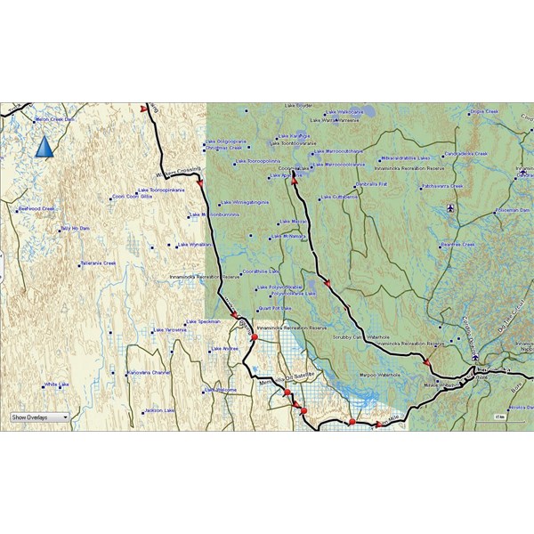
Reply By: luxtourer - Wednesday, Feb 13, 2019 at 13:28
Wednesday, Feb 13, 2019 at 13:28
This map was posted on the
forum back in 2014. It may no longer exist, and would probably be out of bounds to anyone but Santos workers anyway.
Cheers
John
Shortcut?
AnswerID:
623826
Reply By: Member - DOZER - Friday, Feb 15, 2019 at 14:58
Friday, Feb 15, 2019 at 14:58
There is a short cut but it is a private Santos road, and most probably gated. We were there last year, took the developement road from
Birdsville to
Innamincka then Congee. Seen the shortcut but was put off by the signs and potential to get lost
AnswerID:
623870