How to Navigate to a Street Address using ExplorOz Traveller

Submitted: Tuesday, May 12, 2020 at 20:28
ThreadID: 140004 Views:8417 Replies:2 FollowUps:6
This Thread has been Archived
Here is the 3rd tutorial in the new series. Now available on the ExplorOz YouTube channel.

Michelle Martin
Marketing & Customer Support
I.T. Beyond Pty Ltd / ExplorOz

Lifetime Member
My Profile  My Blog  My Position  Send Message
Moderator

Back Expand Un-Read 3 Moderator

Reply By: Member - Core420 - Wednesday, May 13, 2020 at 09:58

Wednesday, May 13, 2020 at 09:58
Great stuff Michelle. I have watched and enjoyed each tutorial and learned from them. Keep it up, it's much appreciated!
AnswerID: 631523

Reply By: Member - Boobook - Wednesday, May 13, 2020 at 18:30

Wednesday, May 13, 2020 at 18:30
Looks good Michelle.

Does it work offline?
AnswerID: 631535

Follow Up By: ExplorOz Team - Michelle - Thursday, May 14, 2020 at 12:15

Thursday, May 14, 2020 at 12:15
The Address look up tool uses an online database that can find buildings like in this example, the Melb airport, as well as all street address, so no this feature does not work offline as we don't own the database and app users don't download the database when they get this app.
Michelle Martin
Marketing & Customer Support
I.T. Beyond Pty Ltd / ExplorOz

Lifetime Member
My Profile  My Blog  My Position  Send Message
Moderator

0
FollowupID: 907674

Follow Up By: Frank P (NSW) - Thursday, May 14, 2020 at 12:48

Thursday, May 14, 2020 at 12:48
That leads on to another question that I've often thought about, Michelle.

You DO own the Places database. Would it be possible to incorporate off-line navigation calculation to Places into the app?

I guess there's a reason it's not there, but if you could do it, it sure would be icing on the cake.
FrankP

Lifetime Member
My Profile  My Blog  My Position  Send Message
Moderator

0
FollowupID: 907675

Follow Up By: ExplorOz Team - Michelle - Thursday, May 14, 2020 at 14:55

Thursday, May 14, 2020 at 14:55
Frank, I'll try to answer this without Davids input and as you know I'm not the developer but have a "fair" idea of what's going on - I'm also not as "technically" minded so my explanation is as best as I can give with what I know.

Firstly, we do offer offline navigation to "Places" in the app. This works by knowing the coordinate of your current position, and the coordinate of the Place you are going to. This calculation can be made offline as it uses the known coordiantes in the Places and calculates distance using an internal formula. That is what is shown in the nav panel. The info shown in the nav panel will display the calculated DISTANCE but not a travel time as it doesn't have access to a database that gives the speed limit or road surface for these road to be travelled. In fact it "ignores" the road database completely and only uses GPS calculations.

So here's a little example - Geelong to Melb Airport offline straight line calculation. Obviously over a distance of 80km around a bay and in urban environments it would be ridiculous to expect the system to give any meaningful result if I only select the end destination so I've entered 6 Places. The nav plan is therefore building straight line data from Place to Place. Obviously the more Places I insert the more accurate the distance calcs will be. But for this example we got pretty darn close to what will be calculated when online as you'll see when you compare the two examples:-
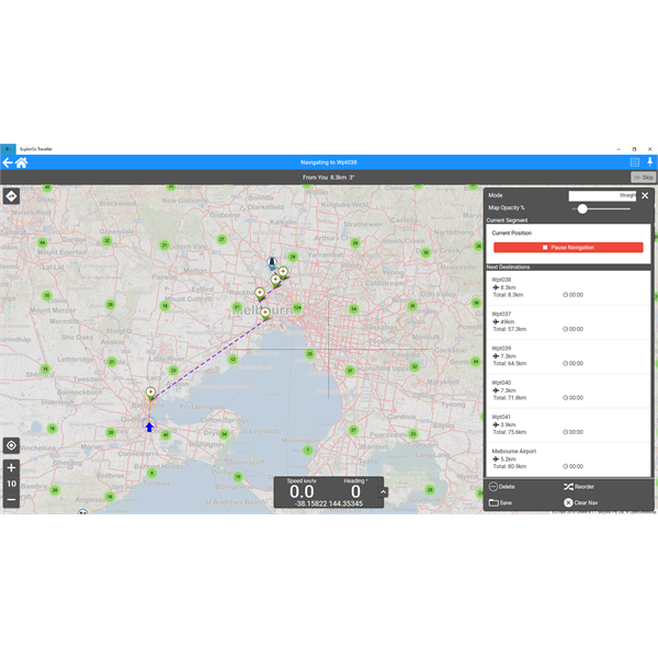


So, now lets look at what you get for the same nav plan if I build it online.
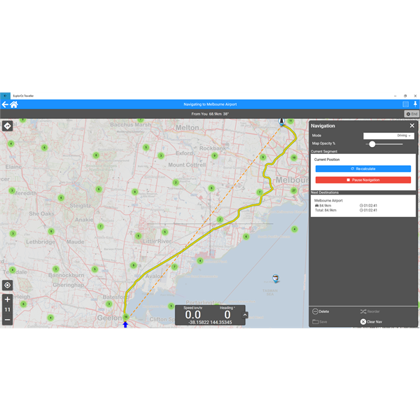

So, as you can see you can indeed build navigation offline using straight line. You just need to be realistic and insert waypoints (Places) if you want a more realistic distance result to be calculated.

BUT, this is all just about the PLANNING. The real thing about navigation is what data do you get, and what do you want to see when you are actually moving - ie. travelling towards your selected destination?

In both the above scenarios, the ETA data will be calculated in the app using local data from the GPS directly which doesn't need internet/online connectivity. This info is displayed for the current segment you are travelling along - ie. Place to Place. Even if you have built a straight line route, and are offline during travel, yo will get an ETA - TIME to reach destination. This info comes from the GPS and is constantly updating as you move towards the selected PLACE (your next destination). The thing is however, this info DOESN'T appear in the nav panel on the right hand side - it is an active onscreen message that pops up at the top of the screen so I actually don't have a screen shot of it - but you will see it when you are driving. This is the part of the app that I discovered myself as navigator last year doing the Karijini trip when I gave up using the saved Private Trek because we were also going off course to explore and then David would ask me questions like "how much further til we get to ... blah" or "how long will it take us now to get to that point you wanted us to go?" and all I had to do was press the desired Place on the map (we were offline) and press GoTo and the app would tell us that info as we travelled towards it. As chief trip planner and navigator on all our journeys, this is the info that I find that most useful to tell our driver about our progess as the day's trip unfolds. It's all well and good to have PLAN but we all know that what happens on the road rarely goes exactly to plan ;) Knowing that the app can give you this data offline is really important.

So the message here, is don't negate what the app does offline. Just because it can't draw a pretty line following the path of the road - you can see the road, but the data you want is the travel time and distance. It will give you that as I've described but you'll need to help it along by insert Places that aren't too far apart, and letting the live calculations auto-update the ETA as you travel.

Hope this explains it a bit? Or have I missed the point?
Michelle Martin
Marketing & Customer Support
I.T. Beyond Pty Ltd / ExplorOz

Lifetime Member
My Profile  My Blog  My Position  Send Message
Moderator

2
FollowupID: 907681

Follow Up By: Frank P (NSW) - Thursday, May 14, 2020 at 18:27

Thursday, May 14, 2020 at 18:27
Thank you Michelle. Yes, I do that too, using Places and sometimes waypoints to create a route that simulates a road.

But what I was really asking was, is it possible to have the app, WHILE OFF LINE, calculate the "pretty line that follows a road" as you call it :-) and the turn by turn instructions in the way that self-contained street navigator apps like CoPilot and similar and built-in vehicle navigators do?

Maybe not an address lookup, though that would be nice, but using your Places database instead of an address database.

FrankP

Lifetime Member
My Profile  My Blog  My Position  Send Message
Moderator

0
FollowupID: 907700

Follow Up By: ExplorOz Team - Michelle - Thursday, May 14, 2020 at 19:29

Thursday, May 14, 2020 at 19:29
We cant offer that a the moment for 2 reasons:
1. whilst we have mapped roads and tracks, these dont all have necessary routing data which is required to extract turn-by-turn directions ..ie. road type surface for every portion, speed limits for every portion, lane size limits for every portion (ie. 1 way or two way roads). Our database just doesnt have that info for 100% of roads/tracks.
2. If we did have the above data, it would increase the size of map downloads so we couldnt do it unless we could reduce the size of existing map files - which we have a solution for via a change to use the Vector format for providing maps in the app but this will also require development of a new app that is Vector compliant. The apps you refer to that offer it are Vector.

To move forward with these 2 issues we need more revenue from sales than what we are currently seeing to cover the expense of development. David would need to work full time on the project which would stop him working on other client projects which wouldnt be feasible in the current COVID downturn that has hit us hard and we are currently surviving on job keeper and focussing on other revenue earning projects. Until we climb out of the COVID downturn this is an unlikely project and COVID couldnt have come at a worse time - as we are a seasonal business with March-Aug sales needing to cover us for the other 6 months of the year. Obviously we're already too far into this season to make a comeback so our downturn will have a long-reaching effect well into mid-next year. Maybe after a good solid year in 2021, we could hope for this in 2022?

We have tons of great things gor both apps in the pipeline however and in a few days I'll be releasing details of new features in both Traveller and Tracker.
Michelle Martin
Marketing & Customer Support
I.T. Beyond Pty Ltd / ExplorOz

Lifetime Member
My Profile  My Blog  My Position  Send Message
Moderator

0
FollowupID: 907703

Follow Up By: Frank P (NSW) - Friday, May 15, 2020 at 10:57

Friday, May 15, 2020 at 10:57
Thanks again, Michelle. I had suspected that the raster/vector thing might have been a factor, so it's good to hear that a change to a vector model is in the pipeline, other circumstances permitting. Those "other circumstances" are a real worry. Every day in the newspaper you read of a new twist, a new previously unsuspected or unrealised impact. I sincerely hope you can weather the storm.

Looking forward to those new features!
FrankP

Lifetime Member
My Profile  My Blog  My Position  Send Message
Moderator

1
FollowupID: 907719

Sponsored Links