Using station tracks shown in EoTopo & Satellite imagery
Submitted: Friday, Dec 05, 2025 at 12:56
ThreadID: 151938
Views:686
Replies:7
FollowUps:9
Member - peter_mcc
I'm planning (dreaming?) of trip heading south from Mt Isa in the middle of next year. Looking at EoTopo/Traveller and satellite imagery I can see lots of tracks that take shortcuts across otherwise "blank" areas. How do I work out if I can use them and/or who to contact to get permission?
For example, I'd like to cut south from
Fountain Springs to
Duchess via some of the old
Burke & Wills Camp 99 and
Burke & Wills Camp 98 (tracks visible on satellite imagery) or cut across to
Devoncourt(via tracks on EoTopo/Traveller).
I'm guessing they are station tracks.
Using Queensland Globe I can find the name of the stations who's land I'd be passing through -
https://qldglobe.information.qld.gov.au/?topic=property - turn on the "Property Names" layer then zoom in a bit. You might want to turn off things like lot numbers and council boundaries.
Some of the stations have websites with contact details I can find on the web. Some I can't find anything about.
How does it work getting permission? Do I just ring up and say "hi can I drive on your tracks"
well in advance? Do I ask for anyone in particular? Email them my plans & ask? Drop in when I'm nearby (which would be asking for forgiveness rather than permission because they are at the end of my track usage)? Sneak through and hope nobody notices?
Has anyone got any tips?
Perhaps related to that, how do I tell if something is a public road or a station track? EoTopo, Google Maps, QLD topo maps, etc all show lots of roads. Some are public but I think some are not - is there any easy way to tell? Could I assume if Traveller or Google Maps sends me down a road that it is ok to travel?
Reply By: Stephen L (Clare) SA - Friday, Dec 05, 2025 at 16:17
Friday, Dec 05, 2025 at 16:17
You have raised a very valid point and unfortunately some of the tracks shown on the EO maps are private and are not for public use. This can cause a major issue with your insurance company if you come to grief on a non public/private road.
For this very reason, I contacts another major map producer here in Australia and asked this very question and their reply was very simply.
For legal reason, the major competitor only shows roads and tracks that can legally be driven on by the public, as they are
well aware there are far more tracks out there that are private.
AnswerID:
648743
Follow Up By: Member - Cuppa - Friday, Dec 05, 2025 at 20:06
Friday, Dec 05, 2025 at 20:06
The other major map producer, presumably Hema? may
well do as you suggest, but they also tend , when there are multiple tracks, all kosher to travel on, & generally meeting up again after a while, to show the 'main one in use' only. Occasionally this usage changes & if relying on that now 'incorrect one' can cause some degree of uncertainty, and/or anxiety. Having the Exploroz map with the other tracks shown is very helpful in those circumstances.
FollowupID:
930258
Reply By: Member - Cuppa - Friday, Dec 05, 2025 at 19:52
Friday, Dec 05, 2025 at 19:52
We take the view that if a track is shown on the map & doesn't have a
locked gate or a
sign saying 'Private Keep out' (or similar) then it is likely a public right of way. That doesnt mean that we won't ask for permission if that is a practical thing to do.
Sometimes the the track passes a
homestead, & on occasions we have stopped to ask, or called them up on the UHF. This on occasions has seen us receive directions to a
nice camp site we wouldn't otherwise have know about.
Only once did we get into 'trouble'. There were no signs & no locked gates, but we did pass through a few gates which were shut (leaving the as we found them of course). After something like 20 or 30kms we found that we had begun to go off the line on the map a little & stopped at a
Y Junction. A car at some stockyards in the distance, a red Patrol I recall, driven by a rather grumpy old fella left the yards & came to where we were.
He asked what we thought we were doing there, clearly not happy about our presence.
I was trying to explain we were following 'this track on the map'. He interupted me saying " This track ain't been used for forty fu*kin' years" & said "I'll take you back to the main road". I countered this by assuring him we didn't wish to inconvenience him & could find our own way back with ease. "No, you'll follow me" he said in a manner which clearly indicated we werent being given a choice. . As we passed the
homestead another car pulled out to be behind us. It was clear we were being escorted off the property. As we reached the final
gate the chap in front pulled over to open the
gate & subsequetly turned around to drive back in the direction of the
homestead after shutting the
gate once we & our rear escort had passed through it.
Reaching the road I pulled up & the car behind pulled up along side us. I got out & approached saying something like "
Well that was all a bit unexpected". "Oh don't worry about it" the chap said. "Ee's a grumpy ol' bastard, one of two brothers who live on their own up there. I agist some cattle on their place. Ee'll love telling that story about a couple of crazy tourists drivin' into his place down at the pub for years to come" & winked. We shook hands & he drove off in one direction & us in the other.
AnswerID:
648744
Follow Up By: Allan B (Sunshine Coast) - Saturday, Dec 06, 2025 at 09:32
Saturday, Dec 06, 2025 at 09:32
.
Cuppa, you are lucky that you did not encounter a Sovereign Citizen and get a shotgun shoved up your nose.
FollowupID:
930260
Reply By: IvanTheTerrible - Friday, Dec 05, 2025 at 20:23
Friday, Dec 05, 2025 at 20:23
If it isn't named then treat it as private. Exploreoz is useless for identifying private tracks, use Hema instead as they list them as private or MVO. DO NOT USE GOOGLE SATTELITE! A group of 4x4s decided to drive from Mt Freeling to
Arkaroola on a private road and collided with a side by side and injured 2 occupants. The station is now trying to restrict access on Umberatana road because of this. The amount of people trying to drive from
Arkaroola to Hawkers
gate has left the station manager very angry.
AnswerID:
648745
Reply By: Member - peter g28 - Friday, Dec 05, 2025 at 20:35
Friday, Dec 05, 2025 at 20:35
Personally, I find getting the permission of the landowner is the way to go, in this case I wanted to visit a B&W site located on private property, so I rang the local Tourist Infomation centre. I gave the info they requested and within the week I received an email with the name and phone number of number of the property owner...so I spoke with them personally.
Now some property owners do not want people trekking across their land as they are a working station, in this case, I go to plan B or go different way or disregard the location all together and put it on the back burner..to be looked at later on.
AnswerID:
648746
Reply By: Peter_n_Margaret - Saturday, Dec 06, 2025 at 09:23
Saturday, Dec 06, 2025 at 09:23
In South Australia, we also have
23 Public Access Routes which are private pastoral tracks that the public can use without special permission (with conditions) to access points of interest.
They should be checked before use as they are sometimes closed for various reasons.
List of PARs.Map of PARs
I am not aware of equivalents to this great arrangement in any other States.
Cheers,
Peter
OKA196 motorhome
AnswerID:
648748
Follow Up By: Allan B (Sunshine Coast) - Saturday, Dec 06, 2025 at 09:46
Saturday, Dec 06, 2025 at 09:46
.
Peter, That S.A. arrangement has worked
well.
But your link to "List of PARs" leads to the map. Is
this the one you intended?
FollowupID:
930261
Follow Up By: Peter_n_Margaret - Saturday, Dec 06, 2025 at 11:27
Saturday, Dec 06, 2025 at 11:27
Correct Allan, thanks.
Cheers,
Peter
OKA196 motorhome
FollowupID:
930263
Follow Up By: Allan B (Sunshine Coast) - Saturday, Dec 06, 2025 at 11:30
Saturday, Dec 06, 2025 at 11:30
We all get on the wrong track sometimes Peter. lol
FollowupID:
930264
Reply By: ExplorOz - David & Michelle - Saturday, Dec 06, 2025 at 22:02
Saturday, Dec 06, 2025 at 22:02
Whilst EOTopo certainly shows a huge amount of minor outback and regional tracks, we also clearly indicate any that are known private tracks with both a text label and a distinct line style/colour. Our mapping also includes land-use shading for areas such as:
• IPA – Indigenous Protected Areas (usually no public access on any track within an IPA)
• Native Title areas
• Military restricted zones
• Mining restricted zones
• Management Vehicle Only tracks in Parks/
Reserves
Many pastoral stations also have tracks passing through them that are gazetted public roads. These remain publicly accessible, but travellers must still respect landowner rules such as no shooting, no
camping, and closing gates. These requirements are usually signposted on-site.
Below are a few screenshots to illustrate how this appears in EOTopo:
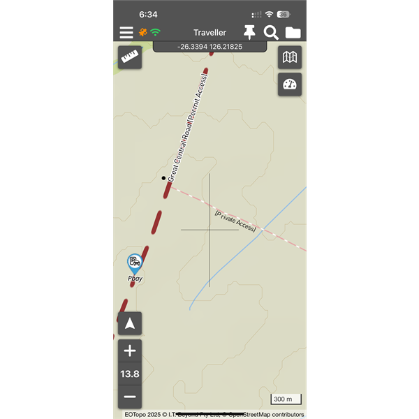
Private track is labelled
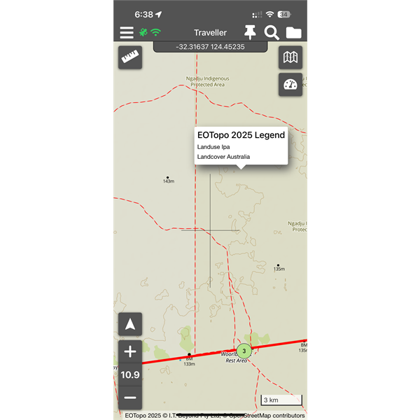
Shaded land area - dynamic legend says IPA
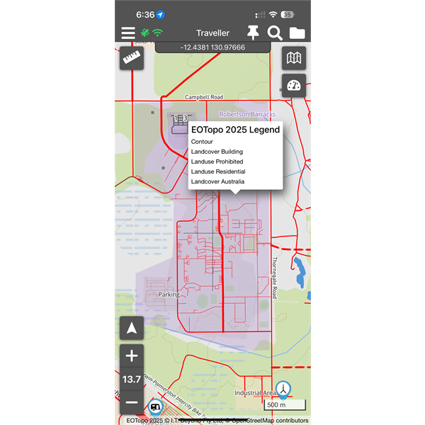
Shaded area - legend says prohibited (military)
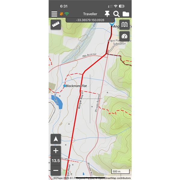
Private Road labelled & diff colour
We produce enhanced topo maps, and they are widely used — not just by travellers, but by land owners, and emergency
services crews who rely on this level of detail to locate old or overgrown tracks during critical operations.
Accurate mapping of this data is vital, and travellers are only one of many users who depend on our product.
We also do actively delete non existent roads each year when creating new editions of EOTopo.
Hope this is useful
Michelle
AnswerID:
648749
Follow Up By: Member - peter_mcc - Sunday, Dec 07, 2025 at 08:55
Sunday, Dec 07, 2025 at 08:55
For me the question becomes - can I drive on a track that is shown on EOTopo if it isn't marked as private? I can find examples of "red" tracks in National Parks around
Sydney that are closed to vehicles for the public so I'm not confident that the lack of a "private road" marking means I'm allowed there.
For example, the track from
Fountain Springs to Devoncourt:
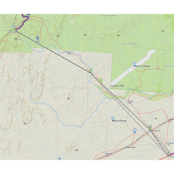
Fountain Springs to Devoncourt, QLD
It's not shown as private. It exists on Satellite imagery. It doesn't exist on the Traveller "routing" layer (hence the straight line segments). It exists on Google Maps, it doesn't exist on Bing Maps. It isn't shown on the older HEMA maps I have (to be fair they don't show anything in that general area, including
Fountain Springs and the road to it!). It does show in an old QLD 1:250k topo.
How do I tell if I need permission to drive it?
FollowupID:
930265
Follow Up By: Member - shane r1 - Sunday, Dec 07, 2025 at 15:24
Sunday, Dec 07, 2025 at 15:24
Sorry to be “picky” but you shouldn’t say “shut gates”
It should be practice proper
gate etiquette .
FollowupID:
930267
Follow Up By: ExplorOz - David & Michelle - Sunday, Dec 07, 2025 at 18:42
Sunday, Dec 07, 2025 at 18:42
Shane - you're joking surely?!!!
MM
FollowupID:
930268
Follow Up By: ExplorOz - David & Michelle - Sunday, Dec 07, 2025 at 18:48
Sunday, Dec 07, 2025 at 18:48
Pete, if I was you with these queries I’d make enquiries locally. The map shows this land is all under native title and theres that historic tramway. The Place notes discuss access along the 4wd track from the north along the disused tramway but not on the southern section you are interested in.
MM
FollowupID:
930269
Reply By: Member - Gordon B5 - Monday, Dec 08, 2025 at 00:54
Monday, Dec 08, 2025 at 00:54
I understand where Shane is coming from. Shut the
gate means shut the
gate.
Gate etiquette means leave it how you found it. Having had a couple of service businesses over the years you have to treat people as if they have absolutely no idea, because some of them don’t. Yes there is a a name for them. Shutting an open
gate could stop stock getting
water at the very least. Not trying to be smart it’s just how we have to live these days.
AnswerID:
648750