Kiwirrkurra to Balgo Track
Submitted: Sunday, Dec 08, 2013 at 14:17
ThreadID:
105414
Views:
5459
Replies:
5
FollowUps:
16
This Thread has been Archived
Member - Jim R (ACT)
I am interested in finding out more about the
Kiwirrkurra to Balgo track. If there is anyone out there who has traveled it in recent years I would love to hear of your experiences.
Reply By: Idler Chris - Sunday, Dec 08, 2013 at 16:07
Sunday, Dec 08, 2013 at 16:07
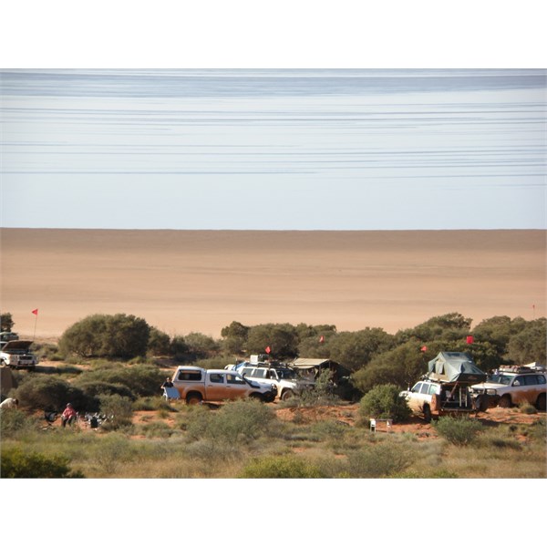
Travelled this track in July this year. Great track, it is not maintained so rough in spots and when we travelled it there were some quite muddy sections. I would not imagine it would by muddy to often after all you are in the middle of the
Great Sandy Desert. In terms of difficulty think CSR and Ann Beadell Hwy. There are some
well travelled people who would say this is one of the the most remote tracks in Australia.
This track is not for the faint hearted only the very
well prepared and experienced travellers with a minimum of three vehicles and the more the safer, it is sooooo isolated.
| What other people think of me is none of my business.
Do unto others what you would have them do unto you.
The word "hate" is not in my vocabulary. Lifetime Member
My Profile My Blog My Position Send Message |
AnswerID:
522754
Follow Up By: Idler Chris - Sunday, Dec 08, 2013 at 16:46
Sunday, Dec 08, 2013 at 16:46
Lake Mackay is a
camp spot not to be missed. When we were there the wind changed and the waterline which was over 500 metres away was 300 metres closer within 5 hours.
| What other people think of me is none of my business.
Do unto others what you would have them do unto you.
The word "hate" is not in my vocabulary. Lifetime Member
My Profile My Blog My Position Send Message |
FollowupID:
803900
Follow Up By: Idler Chris - Sunday, Dec 08, 2013 at 16:50
Sunday, Dec 08, 2013 at 16:50
Another must see is the LB's ration truck at
Kiwirrkurra.
| What other people think of me is none of my business.
Do unto others what you would have them do unto you.
The word "hate" is not in my vocabulary. Lifetime Member
My Profile My Blog My Position Send Message |
FollowupID:
803901
Follow Up By: Member - Jim R (ACT) - Sunday, Dec 08, 2013 at 16:54
Sunday, Dec 08, 2013 at 16:54
Thanks Chris. Yes we are experienced and equipped for such areas but are simply doing research at this stage. Do you happen to have any track plots you can share?
FollowupID:
803903
Follow Up By: Idler Chris - Sunday, Dec 08, 2013 at 17:52
Sunday, Dec 08, 2013 at 17:52
Lake Mackay
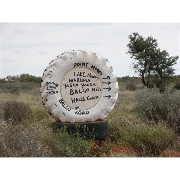
Sign southern end of Balgo track
A couple of photo's click for a description.
| What other people think of me is none of my business.
Do unto others what you would have them do unto you.
The word "hate" is not in my vocabulary. Lifetime Member
My Profile My Blog My Position Send Message |
FollowupID:
803909
Reply By: Mick O - Sunday, Dec 08, 2013 at 16:33
Sunday, Dec 08, 2013 at 16:33
I concur with Chris. This is a remote and rough track. The corrugations at the northern end are equal to anything on the Canning. Quite sandy in
places and very weather affected. The southern 80 km are OK out to the dwarf
well tank but after that, it's very much a mixed bag.
This is a closed track and even the locals don't travel on it lightly. You will need permission and will need to show your experience, preparations equipment level and numbers travelling. You will also need to provide an undertaking that indemnifies the traditional owners if any misfortune befalls you while on the track.
Cheers Mick
(P.S. We were on it i August this year)
AnswerID:
522758
Follow Up By: Member - Jim R (ACT) - Sunday, Dec 08, 2013 at 16:52
Sunday, Dec 08, 2013 at 16:52
Thanks for the advice. Yes we are aware that it is REMOTE and are quite experienced in such areas. We have no definite plans at this stage but are simply doing research. Do you happen to have track plots that you can share.
Again thanks for the prompt responses.
FollowupID:
803902
Follow Up By: equinox - Sunday, Dec 08, 2013 at 17:31
Sunday, Dec 08, 2013 at 17:31
Hi Jim,
I will send you a plot and contact details off-
forum.
Further to what Mick says you probably will have to show you have a bona-fide reason for traveling it, especially if you wish to visit some of the
places that are away from the track. I would not recommend traveling the track without permission - it may cause future access issues if you are caught, similar to what happened a few years ago on the CSR.
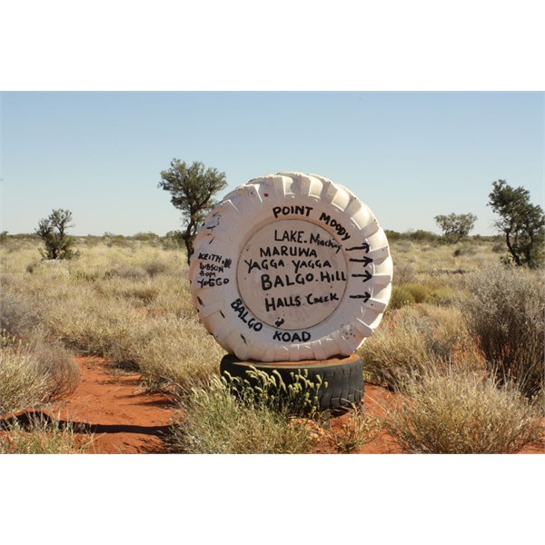
Sign at southern terminus
Cheers
Alan
FollowupID:
803907
Follow Up By: Mick O - Sunday, Dec 08, 2013 at 22:21
Sunday, Dec 08, 2013 at 22:21
Jim, if you go to my profile page and then to "my map", you'll find the plot there. It's called 10-Jun-09. You should be able to zoom in on it, click on it to highlight and as an EO member, download it. I'm sorry but it also covers the
Gary Junction from
Papunya, I didn't bother to trim it at the time of loading.
Other than this year, I was on the track in 2009 and have written it up in the blog section on EO.
Link to day one - North to Lake McKay
Cheers Mick
FollowupID:
803930
Follow Up By: Member - Jim R (ACT) - Monday, Dec 09, 2013 at 10:06
Monday, Dec 09, 2013 at 10:06
Thanks Mick - you certainly seem to have had an interesting trip. I am still looking for the 10 Jun 09 track but so facr it has eluded me among your many others.
FollowupID:
803947
Reply By: Echucan Bob - Sunday, Dec 08, 2013 at 22:01
Sunday, Dec 08, 2013 at 22:01
Jim
I refer to it as the
Lake Mackay Track. It's 5 years since we travelled from Balgo south as part of a continent crossing trip from the Arafura Sea north of
Kununurra to the Bight. We didn't go to
Kiwirrkurra - we hit
the Desert Road at Mt Webb and turned east toward
Kintore.
The track conditions were not that difficult, but we found navigation a bit of a challenge as there are many cleared lines etc to confuse. We had the express consent of the TO in Balgo to travel here.
It is very isolated, and there is NO passing traffic.
The other guy who has spent time out there and written about it is Willem Kempen - ex member.
Bob
AnswerID:
522768
Follow Up By: Idler Chris - Sunday, Dec 08, 2013 at 23:38
Sunday, Dec 08, 2013 at 23:38
If you look at the photo's the
sign is clearly marked Balgo Road.
Lake Mackay is just one of the features along this road.
| What other people think of me is none of my business.
Do unto others what you would have them do unto you.
The word "hate" is not in my vocabulary. Lifetime Member
My Profile My Blog My Position Send Message |
FollowupID:
803932
Follow Up By: Mick O - Monday, Dec 09, 2013 at 07:37
Monday, Dec 09, 2013 at 07:37
Bob, that straight through section to Mt Webb has suffered a hell of a lot in the time since then. I was on that section in 09 (on the Kempen expedition) and it was in reasonable nick. Since then, the track has suffered from run-off with large sections now being eroded and very difficult to navigate. One side of the laterite range is now a Gully making things somewhat awkward. In other areas, the track is gone or overgrown and you will need to navigate through the bush. At the northern end, the entry has been graded over and it is very easy to miss. You really would need the coordinates to assist in locating the turn off.
The main Balgo Road is in fantastic nick out to Lake McKay having been graded to support the exploration efforts in the area. Past Lake McKay it deteriorates markedly.
Cheers Mick
FollowupID:
803937
Follow Up By: Echucan Bob - Monday, Dec 09, 2013 at 08:52
Monday, Dec 09, 2013 at 08:52
Mick, it sounds like we will be using the
Kiwirrkurra section next time.
Chris, on leaving Balgo a
sign proclaiming "Balgo Rd" would be unhelpful.
Lake Mackay is the major feature along the road, so whether you start from Balgo,
Kiwirrkurra or Mt Webb you know where you are going to end up (with any luck!).
Naming roads after a point at one end can be ambiguous. Eg there are four roads leading to the Sandy Blight
Junction but only the road leading South is called the
Sandy Blight Junction Road. While not wishing to be critical of LB, what should the road north to Nyrripi be called?
Which is why I call it the
Lake Mackay Track (before the miners graded and signposted it)
Bob
FollowupID:
803940
Follow Up By: Idler Chris - Monday, Dec 09, 2013 at 09:46
Monday, Dec 09, 2013 at 09:46
Bob, there is nothing wrong with your logic and I understand what you are saying and probably agree with you as would most others who have been there. However I would suggest that the vast majority of the persons who wish to go there and read this
forum would be better served by calling it the Balgo road because that is what the
sign says and is what the community of Kiwirrakurra call it. Much less confusing to intending visitors for the first time. If
Lake Mackay is your destination then there is only one road north and anyone in the community will tell you that it is on the Balgo road which if you have come from the east you will have seen on your way in.
| What other people think of me is none of my business.
Do unto others what you would have them do unto you.
The word "hate" is not in my vocabulary. Lifetime Member
My Profile My Blog My Position Send Message |
FollowupID:
803942
Follow Up By: equinox - Monday, Dec 09, 2013 at 10:17
Monday, Dec 09, 2013 at 10:17
I reckon the
sign says Point Moody Balgo Road.
The writing on the tyre is not straight but turned clockwise about 15 degrees and Point Moody and Balgo Road are opposite to one another.
Doesn't matter really I guess we all know what road it is.
Cheers
Alan
FollowupID:
803948
Follow Up By: Idler Chris - Monday, Dec 09, 2013 at 10:41
Monday, Dec 09, 2013 at 10:41
Alan is right of course it doesn't really matter, but for those of you who have not been there you had better go there and find out for yourself. You will not be disappointed and probably highly amused.
| What other people think of me is none of my business.
Do unto others what you would have them do unto you.
The word "hate" is not in my vocabulary. Lifetime Member
My Profile My Blog My Position Send Message |
FollowupID:
803952
Reply By: Rick (S.A.) - Tuesday, Dec 10, 2013 at 16:39
Tuesday, Dec 10, 2013 at 16:39
I notice that Don Fuchs, the respected photo-journalist, has a story on this in Pat Callinan's current 4 x 4 Adventures magazine. I think its issue 9.
Cheers
AnswerID:
522858
Reply By: tuck - Wednesday, Dec 11, 2013 at 18:01
Wednesday, Dec 11, 2013 at 18:01
Tour sounds very interesting. With regards to trip taking considerable time -
can I ask what members have done regarding fruit and veg going from eastern states and SA going into WA.
AnswerID:
522908