EoTopo offline maps and Places
Submitted: Wednesday, Jan 08, 2014 at 19:23
ThreadID:
105731
Views:
2020
Replies:
2
FollowUps:
3
This Thread has been Archived
andy
Hi all
Is there an easy way to mark
all Places available through Name Search onto the
EoTopo maps, and if so, how is it done?
I am using Ozi Explorer.
Andi
Reply By: The Explorer - Wednesday, Jan 08, 2014 at 20:30
Wednesday, Jan 08, 2014 at 20:30
Hi
Could be too many
places to plot - Ozi has 10,000 waypoint limit, but I don't have
EOTopo so not sure.
None the less...The name search file (the *.names file) is in reality a *.dbf file that can be opened in excel (or similar)...you can then create a text file (*.csv) using names and coordinates for import as waypoints into Ozi. If there are more than 10,000 suppose you could break it up into states ..or something.
This sounds difficult but it's actually "easy" though if you have no knowledge of excel etc suppose its tough..don't have time to explain process..see how you go.
Ozi website has instructions and a small utility for creating name search files
name search utility
..unfortunately no instructions on reverse process (but as I said it is easy).
Cheers
Greg
PS Aren't all the
places plotted on the map anyway?
| I sent one final shout after him to stick to the track, to which he replied “All right,” That was the last ever seen of Gibson - E Giles 23 April 1874 Lifetime Member
My Profile My Blog Send Message
Moderator |
AnswerID:
524111
Reply By: equinox - Wednesday, Jan 08, 2014 at 21:09
Wednesday, Jan 08, 2014 at 21:09
Hi Andi,
You can have them all marked up on the Ozi PC version easily enough.
Just select the plot location icon and tick "on map".
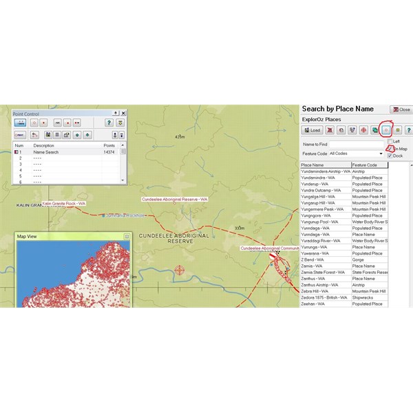
Point on map
You can save these points then, though as the maps are fairly large you will have quite a few points. An option is to select a map in area of interest that is of a smaller scale first to reduce number of points.
This option not available in Android version.
Cheers
Alan
AnswerID:
524114
Follow Up By: The Explorer - Wednesday, Jan 08, 2014 at 21:38
Wednesday, Jan 08, 2014 at 21:38
Good stuff Alan - didn't realise you could plot all points on at map at once...though as you mention can end up with way to many points if you use large area (e.g. small scale map)...but anyway, once points are loaded you can save them as way-points..
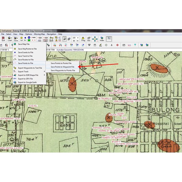
Save Points as Waypoints
You do however lose the feature code from name search file in the process (river, lake, town, etc) and just end up with a name. Process also truncates longer names. Significance of this depends on if you need additional info I suppose.
Cheers
Greg
| I sent one final shout after him to stick to the track, to which he replied “All right,” That was the last ever seen of Gibson - E Giles 23 April 1874 Lifetime Member
My Profile My Blog Send Message
Moderator |
FollowupID:
805704
Follow Up By: Member - wicket - Wednesday, Jan 08, 2014 at 23:26
Wednesday, Jan 08, 2014 at 23:26
Alan
thanks for that tip, been using ozi for a while now and never realized that either ! I've been doing it long hand as Greg alludes to above, was just about to do a huge batch, so you have saved me some mucking around, thanks
FollowupID:
805711
Follow Up By: andy - Thursday, Jan 09, 2014 at 01:53
Thursday, Jan 09, 2014 at 01:53
Alan
Thanks for your help. Finding possible camps marked on a map is very helpful and for me another incentive buying
EOTopo.
Cheers
Andreas
FollowupID:
805714