travelling along the Fitzroy river
Submitted: Tuesday, Jan 21, 2014 at 14:01
ThreadID:
105889
Views:
3055
Replies:
4
FollowUps:
3
This Thread has been Archived
Member - Richard B (NSW)
In early April we will be doing a trip , going west from
Ballina on the East coast to
Broome and then up the Gibb and beyond and I was wondering if there is anyone out there who might have some info of the route OFF the main road at
Fitzroy crossing following the river to come out near Willare bridge. Where possible we prefer to
bush camp so prefer
places off the
well beaten track.
I have been using the search function and seen some good
blogs a but wondered if some one might have more knowledge of the route.
Thanks in anticipation.
Richard.
Reply By: Member - Tony (ACT) - Tuesday, Jan 21, 2014 at 20:01
Tuesday, Jan 21, 2014 at 20:01
The better
camp area is about 20k before you get to the river. From
Broome the T/O is to a sand quarry and you can see the track as it is almost straight ahead on the left.
A
gate is not far in off the road, go through that and follow the track till you come to the sand piles along the river, plenty of
camp sites to choose from.
Good Barra fishing at times, but watch out for crocs.
T/o Cords. 17o 40' 32.9" S, 123o 28' 47.2" E. The crossing there is called Langey Crossing and all you can still see the remains of the old bridge.
AnswerID:
524879
Reply By: Member - John Baas (WA) - Tuesday, Jan 21, 2014 at 23:11
Tuesday, Jan 21, 2014 at 23:11
Hi Richard.
We've tried 3 times to get from Noonkenbah to the Crossing and totally failed. The first time we finished up east of FC via the near desert; the other two times we couldn't find our way thru the track maze east of Noonkenbah.
On making later enquiries, the helpful people at FC tourism were very confident that it was either Aboriginal business only or permissions would have to be got from pastoralists, which they said they weren't confident we'd get. I'll prob try again when I get some more time.
On the other hand, the tracks between
Camballin to Noonkenbah are open and easy, and filled with POI's around the old
Camballin project; the barrage at Fitzroy weir is not to be missed.
See image for a plot from Willare to NKB, and back nth to the hwy.
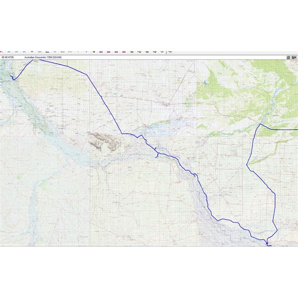
Noonkenbah Plot Image
Cheers.
AnswerID:
524900
Follow Up By: Member - John Baas (WA) - Wednesday, Jan 22, 2014 at 13:16
Wednesday, Jan 22, 2014 at 13:16
Hi again Richard.
Have just been looking at the EO mapping - see image. Shows River Road going all the way to FC. Whether it actually exists is the Q. Worth a look tho.
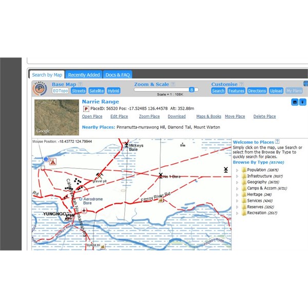
Fitzroy River Road
Cheers.
FollowupID:
806784
Reply By: Member - Warrie (NSW) - Wednesday, Jan 22, 2014 at 10:58
Wednesday, Jan 22, 2014 at 10:58
Hi Richard, you could try Ron Moon's book - The
Kimberley, available here at Ex Oz. It has a detailed section on what you are asking about, pages 165 to 172.............. W
AnswerID:
524912
Follow Up By: Member - Richard B (NSW) - Wednesday, Jan 22, 2014 at 19:39
Wednesday, Jan 22, 2014 at 19:39
Thanks Warrie, I know of the book and I just needed reminding - will look at getting a copy.
Richard.
FollowupID:
806795
Reply By: Member - colin M - Wednesday, Jan 22, 2014 at 18:21
Wednesday, Jan 22, 2014 at 18:21
Hi Richard
Suggest get a copy of Birdit-Bradtke's
Kimberley guide www.kimberleyaustralia.com
it was a real bible for our trip last year.
AnswerID:
524951
Follow Up By: Member - Richard B (NSW) - Wednesday, Jan 22, 2014 at 19:42
Wednesday, Jan 22, 2014 at 19:42
Colin, I got a copy ages ago and have it amongst a whole lot of other reading to get through in prep for our trip.....there is a lot of info in it
Thanks for your reply.
Richard.
FollowupID:
806796