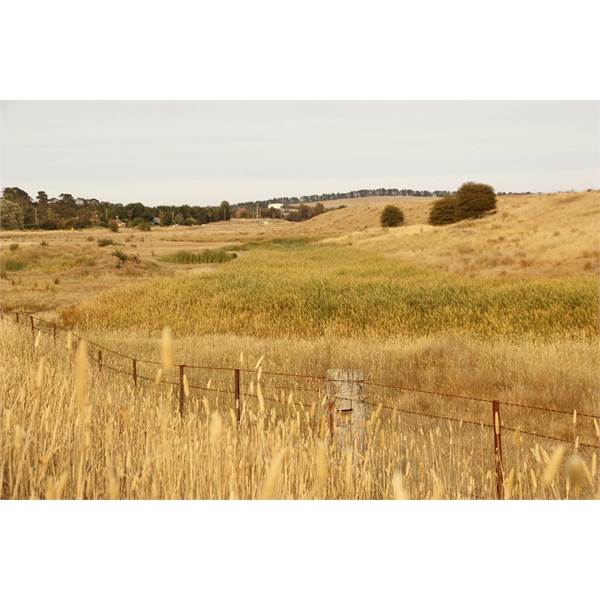
The Lachlan River
Submitted: Saturday, Jan 25, 2014 at 09:34
ThreadID:
105944
Views:
2926
Replies:
3
FollowUps:
5
This Thread has been Archived
Member - John G

The Lachlan north of Gunning

Headwaters
G'day Folks
In Thread 105493 I asked some questions about Banjo Paterson and where he might have met Clancy "down the Lachlan years ago", and about the Lachlan generally.
Last Sunday I went in search of the headwaters, which appear on my Hema map to originate from a large patch of lake or swamp east of Bredalabane which is roughly halfway between
Gunning and
Goulburn. The large patch of blue on the maps is un-named, and Google earth Earth shows it to be a large patch of brown - earth.
The closest I could come to headwarers was a beginning line of brown reeds, which gradually become green within sight of
Breadalbane. Just north of
Gunning, on the Grabben Gullen (where does that name come from?) Road, the Lachlan crosses under the road, and there it is a line of
water.
Reply By: bigden - Saturday, Jan 25, 2014 at 10:01
Saturday, Jan 25, 2014 at 10:01
i remember your original post. so does the river start from a spring or is it just a depression were
water gathers. did you find out much about the other questions?
AnswerID:
525082
Follow Up By: Member - John G - Saturday, Jan 25, 2014 at 11:06
Saturday, Jan 25, 2014 at 11:06
G'day bigden
I was hoping that no-one would ask that question. I'm no geographer but given that maps do show a big 'blue bit' and the Lachlan emrging from that it may be a combination of spring forming a lake/swamp in a depressed area. How's that for a bob each way? Googling hasn't really produced much by way of an answer to your question - maybe somebody on the site will know.
Cheers
John
FollowupID:
806957
Follow Up By: Charlie - Saturday, Jan 25, 2014 at 19:40
Saturday, Jan 25, 2014 at 19:40
Just fired up Oziexploer and if you go by the older paper 25K top map you would think the Lachlan starts to the south of
Breadalbane however the newer digital map list that as Mutmutbilly
Creek.
Perhaps the Lachlan rises between the Bicentennial Trail and the windfarm.
Regards Charles
FollowupID:
806979
Follow Up By: Charlie - Saturday, Jan 25, 2014 at 19:58
Saturday, Jan 25, 2014 at 19:58
Just checked again and the Lachlan starts at
the junction of Mutmutbilly and Hannas Ck so your location further east would be the right one.
Charles
FollowupID:
806984
Reply By: Member - John and Val - Saturday, Jan 25, 2014 at 10:41
Saturday, Jan 25, 2014 at 10:41
Hi John,
Interesting post, and as good a reason as any to go out exploring!
That country around
Breadalbane is right at the top of three catchments - Lachlan, which flows west; Wollondilly that flows east and
Lake George which is an internal drainage basin, although often included in the Murrumbidgee catchment. I was once involved with catchment management and a hydrologist whose knowledge and ideas I respected told me that the small streams in the Breadalbane/Collector area could flow either way depending on the amount of
water in them and wind direction. Right now with so little moisture around they are probably flowing in their "natural" direction.
What else have you found out about BP?
Cheers,
Val
| J and V
"Not everything that can be counted counts, and not everything that counts can be counted."
- Albert Einstein
Lifetime Member
My Profile My Blog Send Message |
AnswerID:
525087
Follow Up By: Member - John G - Saturday, Jan 25, 2014 at 11:17
Saturday, Jan 25, 2014 at 11:17
Thanks Val
Regarding BP and Clancy - there's a bit on that original thread 105493, but to summarise:
1. There's doubt about whether Paterson actually met Clancy "down the Lachlan". Consensus seems to be that as a solicitor he wrote to Clancy chasing up a debt.
2. There was a station called "The Overflow" north of Condoblin. It was subdivided in the late 1920s. A member provided the actual location.
3. There is a view that Paterson wasn't referring to a specific place/location when he referred to the overflow. Overflow apparently also refers to flood plains. The reference to this is in a Bulletin article of many years ago, and I will see if they have a copy in the National Library here in
Canberra.
We're going to do a road trip down the Lachlan from Cowra to Oxley in early April. Looking forward to it.
Cheers
John
FollowupID:
806959
Reply By: Member - Megan and Kevin D (AC - Saturday, Jan 25, 2014 at 15:14
Saturday, Jan 25, 2014 at 15:14
Years ago, Kevin rowed a 10ft tinny from Cowra to
Forbes along the Lachlan. It took about a week and cured him of wanting to row the entire length of the Murray. Very cleverly, he managed to live off the land - rabbits, fish and ducks. We'll be interested to hear more of your discoveries about the Lachlan. Megan
AnswerID:
525101
Follow Up By: Member - John G - Sunday, Jan 26, 2014 at 10:52
Sunday, Jan 26, 2014 at 10:52
LOL Megan
He's a quick learner, your Kevin.
I did a 200 mile canoe trip down the Murray in 1959 with a school mate. We paddled in harmony until the river turned south at
Morgan. Headwinds for the next few days made for strained relationships as whoever was in the front got soaked, while the one in the back tried to direct us across the river looking for a windbreak Excuse the non natical terms.
Cheers
John
FollowupID:
807019