Blue Rag track update
Submitted: Wednesday, Feb 26, 2014 at 18:02
ThreadID:
106435
Views:
4049
Replies:
9
FollowUps:
7
This Thread has been Archived
pepper2
As many would be aware this track has been graded and is now safer and relatively easy,this might lead to some taking camper trailers to the top.However for those that continue past the crest of blue rag down to the river below,be aware that about threequarters down there is an extreemly sharp hairpin to the right that requires a vehicle on its own to do a three point turn,not sure you would get around this with any trailer.
Reply By: Member - Rosco from way back - Wednesday, Feb 26, 2014 at 18:34
Wednesday, Feb 26, 2014 at 18:34
Good advice there.
We had the pleasure of traipsing through the HC some years back sans trailer and were very glad we left it behind. Not having it in tow opened up a plethora of tracks which would have been otherwise inaccessible, due to the hairpin bends which required a 3-point turn to negotiate.
AnswerID:
527282
Reply By: Member - Leigh (Vic) - Wednesday, Feb 26, 2014 at 20:40
Wednesday, Feb 26, 2014 at 20:40
They graded it? Now that is a shame as it was a good track as it was. Oh
well on the upside they haven't put a
gate across it.
AnswerID:
527297
Reply By: Will 76 Series - Thursday, Feb 27, 2014 at 21:12
Thursday, Feb 27, 2014 at 21:12
Yep, agree, it was a great track, quite challlenging in
places, shame about the grading.
The increased traffic will probably also detract a little from the track but all in all it willl still be a good drive for scenery.
Will
AnswerID:
527363
Reply By: mikehzz - Friday, Feb 28, 2014 at 06:50
Friday, Feb 28, 2014 at 06:50
It was graded right after the bushfires, probably so the firies could get in and out quicker if needed. I'd like to see the grader that could grade that track.
AnswerID:
527374
Follow Up By: Shaker - Saturday, Mar 01, 2014 at 21:47
Saturday, Mar 01, 2014 at 21:47
When they did Billy Goats
Bluff track they used a rock grinder to get rid of the steps, probably did the same on Blue Rag.
FollowupID:
809900
Reply By: Bend27 - Saturday, Mar 01, 2014 at 21:36
Saturday, Mar 01, 2014 at 21:36
I have always wanted to continue on past the Blue Rag trig and go down the other side but never have, last time I was up there, about 10 months ago, there was a giant pile of mud and rocks just past the trig, and a
sign saying
track closed, that
sign is obviously gone now? What else can you tell me about the rest of the track, is it a dead end? or could you get through on a quad bike or a trail bike all the way to Mt Murray??
AnswerID:
527500
Follow Up By: Shaker - Saturday, Mar 01, 2014 at 21:48
Saturday, Mar 01, 2014 at 21:48
It would be a pretty ugly spot to cross the river!
FollowupID:
809901
Reply By: pepper2 - Monday, Mar 03, 2014 at 16:24
Monday, Mar 03, 2014 at 16:24
Bend 27 the track goes past the
trig point and decends to a river called i think ...wongungarra.... there are two small
camping spots before you cross the river and then an area for perhaps 4 or so campers with swags etc.The
river crossing was no more than axel height and perhaps 10/15 metres wide,no problem.
you may not get a camper past the hair pin bend about 3/4 the way down. The track comes to a dead end at the second
camping area at the rivers edge.
Please take rubbish out with you not like some previous campers.
AnswerID:
527576
Follow Up By: Member - Boobook - Tuesday, Mar 04, 2014 at 06:55
Tuesday, Mar 04, 2014 at 06:55
Pepper2
What is the track like after the fires last year. I believe the fire came up to the track on the NE Side of
the summit and also the fire authorities burned back all the way from there down to the river.
Is the whole track burned badly?
FollowupID:
810045
Reply By: pepper2 - Tuesday, Mar 04, 2014 at 10:06
Tuesday, Mar 04, 2014 at 10:06
The track is in great condition no damage from fires,there are millions of trees that were burnt the trunks and main limbs remain standing like
grey silent sentinels on the hillsides,the trees along the river do not appear to have been burnt,can email you photos if you provide email address.
AnswerID:
527622
Follow Up By: Member - Boobook - Tuesday, Mar 04, 2014 at 17:03
Tuesday, Mar 04, 2014 at 17:03
Thanks pepper2. I'll be there on the weekend so will see for myself. You gave the answer I hoped for.
Cheers.
FollowupID:
810076
Reply By: Robin Miller - Tuesday, Mar 04, 2014 at 17:38
Tuesday, Mar 04, 2014 at 17:38
Here is river Xing before the fires , interesting to see what its like now.
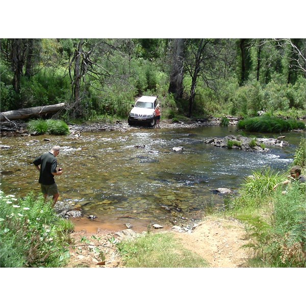
Before
AnswerID:
527642
Follow Up By: pepper2 - Tuesday, Mar 04, 2014 at 18:40
Tuesday, Mar 04, 2014 at 18:40
Robin,i think you carry a sat phone ,just curious if you knew if it workes at the bottom of this valley ???? Did you use it ?? i have a barrett 950 hf that i use to make radio/phone calls using reids radio data.
I had no problem making phone calls from here on the valley floor on about 8meg (through their base in cowra) using the above.
Not looking for a debate on hf vs sat phone,just interested in peoples experiences.
All the best.
FollowupID:
810081
Follow Up By: Robin Miller - Tuesday, Mar 04, 2014 at 20:25
Tuesday, Mar 04, 2014 at 20:25
Didn't try there Pepper , My Barret 950 pinged
adelaide base VKS though.
Most in our group have given up on telstra sat phone in HC though.
Hard to believe but we now use 27mhz ssb car to car as
well as short range UHF.
I believe I got UHF repeater (8?) about 1/2 way down the
hill though.
FollowupID:
810089
Follow Up By: Member - John (Vic) - Tuesday, Mar 04, 2014 at 22:00
Tuesday, Mar 04, 2014 at 22:00
Nice spot.
I have used my Motorola 9555 Sat phone on the a Telstra/Iridium Network extensively through the HC without much of an issue.
FollowupID:
810095
Reply By: pepper2 - Tuesday, Mar 04, 2014 at 18:20
Tuesday, Mar 04, 2014 at 18:20
Robin the
river crossing is virtually unchanged (a couple of new logs in the
water,not in the way) the fires did not get to the river or the
campsite.
AnswerID:
527645