Rudall River NP - Exit West?
Submitted: Saturday, Jun 14, 2014 at 14:17
ThreadID:
108243
Views:
2508
Replies:
3
FollowUps:
4
This Thread has been Archived
Member - John Baas (WA)
Hi Desert Travellers.
Am intending to exit RRNP westish from
Hanging Rock in a few weeks. Does anyone have any recent info on its condition pls? Wondering whether to put the Scratchpro gunk on...
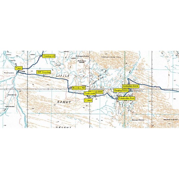
West of Hanging Rock - RRNP
Cheers.
Reply By: Member - Duncan W (WA) - Saturday, Jun 14, 2014 at 17:43
Saturday, Jun 14, 2014 at 17:43
John you may bump into Nick and his Tag-a-long crew as they will be there in late July also.
Have a great trip. RRNP is on my bucket list.
Cheers
Dunc
AnswerID:
534350
Follow Up By: Member - John Baas (WA) - Saturday, Jun 14, 2014 at 19:41
Saturday, Jun 14, 2014 at 19:41
Thanks Dunc.
Yes, I was referred to Nick's blurb by Big Phil... It looks like they'll be out of the
Park about 5 -7 days before I get there, which will be good as they will have done the lawn mowing, hopefully :-).
We're going to get there via the scenic route; a couple of days around
Newman looking at the
Hickman Crater and Punda area, then out along the Skull Springs Rd via the Oakover pools etc, towards Telfer to continue to CSR
well 33; then down to W23 and then exit the CSR via the Talawana to reach the
Park.
Cheers.
John.
FollowupID:
817976
Reply By: Echucan Bob - Saturday, Jun 14, 2014 at 18:21
Saturday, Jun 14, 2014 at 18:21
John,
at
Easter we came down the road from Telfer (having travelled from
Alice Springs). We turned left at Island
Hill, hoping to follow the river and then head south through Parngurr. I refer to the
EOTopo map (
http://www.exploroz.com/EOTopo/Default.aspx#rqc_tabs=3) which looks a lot better than the map you posted.
The track is pretty over grown, with lots of steep
creek crossings. Lots of scratchy branches too! Keep an eye out for my brand new Cooper STT on Land Rover rim. It snapped off its mount on the trailer and disappeared into the scrub!
We got about as far as where Larry
Creek joins the RR. Due to recent rains there was lots of
water about, and the section of the track where you are supposed to drive along the river bed was
well and truly under
water. We had no option but to turn back and exit to the south from Island
Hill.
I reckon the
water should have gone by now so you should be able to get through, but not with your duco intact!
Bob
AnswerID:
534353
Follow Up By: Member - John Baas (WA) - Saturday, Jun 14, 2014 at 19:44
Saturday, Jun 14, 2014 at 19:44
Thanks Bob.
Yes, unless it rains again, should be 'dry as' on the tracks. Our route however will be to chuck a righty (from a sthly heading) at about Island
Hill, heading west.
Cheers.
John.
FollowupID:
817977
Follow Up By: Echucan Bob - Saturday, Jun 14, 2014 at 19:52
Saturday, Jun 14, 2014 at 19:52
John
The information above would be useful if you were exiting to the EAST.
Sorry
Bob
FollowupID:
817980
Reply By: Joe Fury - Saturday, Jun 14, 2014 at 22:42
Saturday, Jun 14, 2014 at 22:42
G'day John Bass
If you intend on visiting the
Hickman Crater and Punda, I strongly advise that you obtain a BHP rail access road travel permit, which is free from the
Newman Visitor Centre.
If you are stopped/quizzed by BHP's people at any point while you are on "their" property you will be asked if you have your permit, as no permit = no travel.
The N.V.C. mud maps are very iffy, with many would be "explorers" getting confused on the multitude of exploration tracks now in the area, with some folk getting confused and unable to reach
the Crater ~ although the track is very
well defined.
The track into Punda is quite wet and due care should be taken, especially in the
creek section of the track.
Safe travels : Joe F
AnswerID:
534378
Follow Up By: Member - John Baas (WA) - Saturday, Jun 14, 2014 at 23:17
Saturday, Jun 14, 2014 at 23:17
Many thanks Joe.
Yes, I intend visiting the NVC for a permit.
I should be OK for the tracks, nav wise. I've looked at their 'mudmap' vis a vis Google Earth and it seems the track is as you say,
well defined. I've also created the GE image for the area as a navigable map, useable with Ozi so I hope to be OK out there.
Thks too for the 'heads up' on the Punda track/s - might have to walk the last couple of kays....
Noted many of your
Newman area images on GE too, thks :-).
Cheers.
FollowupID:
817999