Ozi 3D
Submitted: Saturday, Jun 14, 2014 at 20:54
ThreadID:
108252
Views:
2582
Replies:
1
FollowUps:
5
This Thread has been Archived
equinox
Hi there,
Just wondering how many people utilise Oziexplorer3D?
I've had it as an add on now to Ozi for over 10 years - though only really use it sparingly.
For those who don't know what it is capable of, here is an example.
You select an area in Ozi of interest:
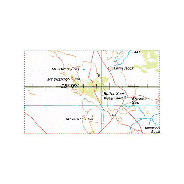
Ozi 3d selection
You then can view the area looking from any angle with the elevation graphically represented:
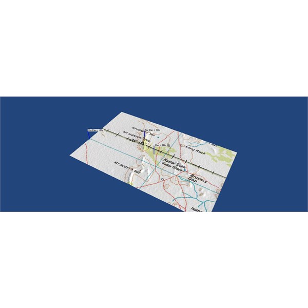
Ozi 3d
You can accentuate the elevations to make them more pronounced if you like. You can also adjust the position of the virtual light source (and shadow).
Ozi 3d
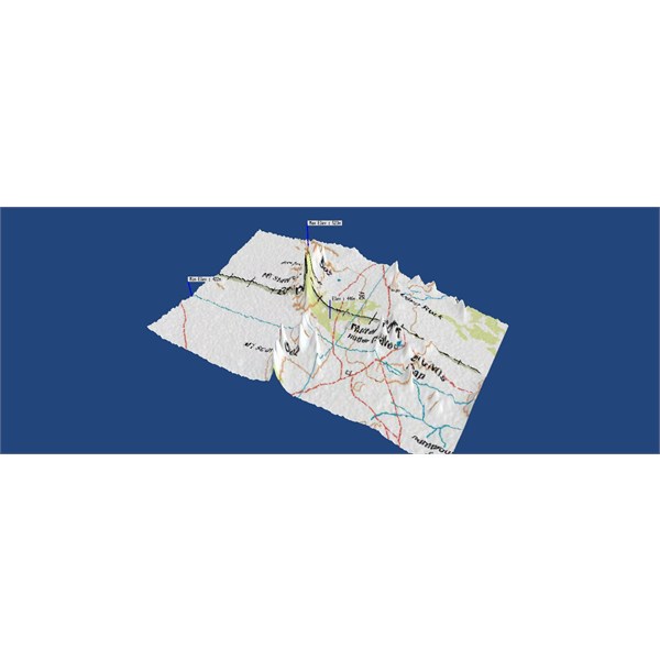
If you want you can eliminate the actual map and just leave elevations gridlines.
Ozi 3d Gridlines
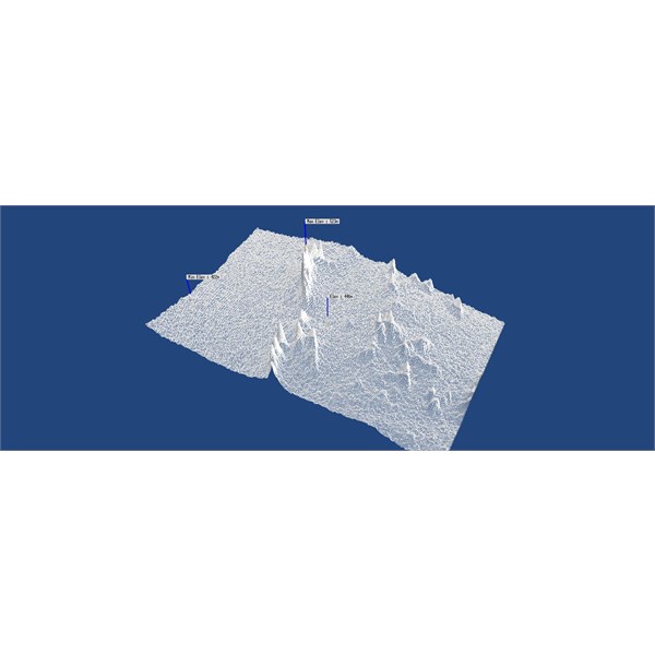
You can also swivel the map around to view it from any angle, and zoom in/out etc.

Ozi 3d
There's a few others features such as 3D profiling and you can show the elevation where the cursor is on the map (and many more).
Great for finding those high and low spots for whatever reason.....
Cheers
Alan
Reply By: The Explorer - Saturday, Jun 14, 2014 at 21:22
Saturday, Jun 14, 2014 at 21:22
Hi
Yeah - used it a few times out of interest..but as you know finding any significant change in elevation in WA can be hard :)
You can use Google Earth (GE) for similar purpose (and free) - here is a plot of a walk I did in 2009.
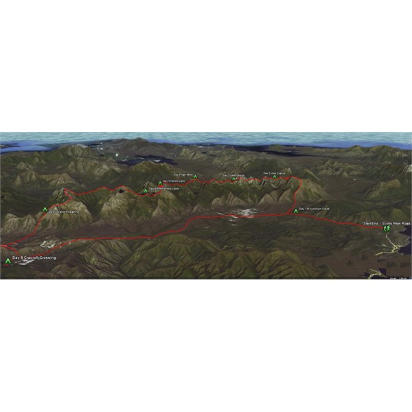
Western Arthurs - Tas
If you convert raster maps to KMZ (e.g. use GlobalMapper (not free)) you can drape them over terrain in GE - same as Ozi but seems to place less drain on PC resources.
All good fun
Cheers
Greg
| I sent one final shout after him to stick to the track, to which he replied “All right,” That was the last ever seen of Gibson - E Giles 23 April 1874 Lifetime Member
My Profile My Blog Send Message
Moderator |
AnswerID:
534371
Follow Up By: Bonz (Vic) - Saturday, Jun 14, 2014 at 23:00
Saturday, Jun 14, 2014 at 23:00
WALK??? What is this wizardry?
FollowupID:
817998
Follow Up By: The Explorer - Saturday, Jun 14, 2014 at 23:57
Saturday, Jun 14, 2014 at 23:57
Hoof it while you can ....the world isn't all red
sand dunes and dried up salt lakes :)

Western Arthurs 2009
Cheers
Greg
| I sent one final shout after him to stick to the track, to which he replied “All right,” That was the last ever seen of Gibson - E Giles 23 April 1874 Lifetime Member
My Profile My Blog Send Message
Moderator |
FollowupID:
818002
Follow Up By: Member - John Baas (WA) - Sunday, Jun 15, 2014 at 01:39
Sunday, Jun 15, 2014 at 01:39
Is that you in the pic Greg....or is it a 'cut and paste' from some Alpine tragic...?
FollowupID:
818005
Follow Up By: equinox - Sunday, Jun 15, 2014 at 11:42
Sunday, Jun 15, 2014 at 11:42
Hi Greg,
Looks like you had a great walk.
Re: PC resources you are right it does use a lot of power - However not so on newish machines. I have a new machine (low-mid level) and have set the number of vertices at the maximum number of 2 million and it seems to process it with no dramas.
FollowupID:
818018
Follow Up By: The Explorer - Sunday, Jun 15, 2014 at 18:44
Sunday, Jun 15, 2014 at 18:44
John - yes me, actually way too much like hard work in my opinion but my mates make me do it.
Alan - apologies for straying off topic. I just remembered using Google Earth to create a 3D representation of the walk so thought Id post it - works very
well...but
You are 100% correct regarding newer PC's and Ozi 3D. I was reminiscing. I also have acquired a newer PC in recent times, haven't tried Ozi3D (despite having license) but have no doubt it will do it easily as you indicate. When it first came out (~2002) it was a bit sluggish on your average home PC but less likely to be an issue now.
3D representation of topo maps/airphotos brings them to life. Ozi3d is a pretty cheap add on and worth it if you have a bit of a passion for studying the lay of the land.
The elevation data required for any map you have loaded can now be downloaded through Ozi which makes is easier that in the past also.
Cheers
Greg
| I sent one final shout after him to stick to the track, to which he replied “All right,” That was the last ever seen of Gibson - E Giles 23 April 1874 Lifetime Member
My Profile My Blog Send Message
Moderator |
FollowupID:
818050