Bullah Bullah Crossing
Submitted: Thursday, Jun 26, 2014 at 09:05
ThreadID:
108496
Views:
2931
Replies:
4
FollowUps:
4
This Thread has been Archived
Member - Simon and Christine G
We are planning a trip to the Simpson via Dig Tree near
Innamincka. I note on the map that there is a crossing or a 'ford' across the Cooper called Bullah Bullah Crossing. Can anyone please advise what this crossing is about and is it worth considering this crossing as opposed to the road around to the east and north (we'll be approaching from the south).
Any feedback would be appreciated.
Reply By: Mikee5 - Thursday, Jun 26, 2014 at 13:01
Thursday, Jun 26, 2014 at 13:01
Now called
Burke and Wills Bridge on newer maps.
AnswerID:
535032
Follow Up By: Member - Simon and Christine G - Thursday, Jun 26, 2014 at 17:11
Thursday, Jun 26, 2014 at 17:11
Thanks for your response. I have recently purchased a Hema HN7 and on that system I cannot find a map that provides the sort of detail needed to properly plan my trip. I'm talking here of the tracks in and around Dig Tree - it shows only significant tracks but no secondary tracks that could be useful to know about.
Can you please tell me what map you are using and if it's on the Hema system what is it called?
FollowupID:
818875
Follow Up By: Member - Allan L2 - Friday, Jun 27, 2014 at 12:49
Friday, Jun 27, 2014 at 12:49
Simon & Christine,
Doesn't the HN7 have the 250 Topo map? I have a Hema HN6 & Bullah Bullah Crossing is shown on the 250 Topo map in the included maps in the unit.
Cheers,
FollowupID:
818921
Follow Up By: Member - Simon and Christine G - Friday, Jun 27, 2014 at 13:21
Friday, Jun 27, 2014 at 13:21
Hi Allan,
Yes that map is included with the HN7 and yes it does show a reasonable amount of detail of the area (interestingly, the same map has very poor coverage of the area around Ophir near
Orange showing no more than major tracks).
The crossing called Bullah Bullah Crossing seems to be at Dig Tree yet there is no evidence of a crossing when I look at Google Earth - I guess it must be a dry weather causeway or as another member has pointed out it could be private. I was just curious to know if there were more details somewhere. That said, it's not an issue because it's only a short trek around the north east to get to the Tree.
Many thanks for taking the trouble to respond.
Cheers,
Simon
FollowupID:
818924
Follow Up By: The Explorer - Saturday, Jun 28, 2014 at 15:07
Saturday, Jun 28, 2014 at 15:07
Hi
The Bullah Bullah Crossing point (a ford) can be seen in Google Earth...but as the
Cooper Creek was underwater at the time the image was taken you cant see the actual ford across the river - just the track either side.
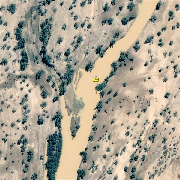
Bullah Bullah Crossing
The
Burke and Wills Bridge referred to by someone else is a different location altogether (~7km up stream) ..and can also be seen in Google Earth.
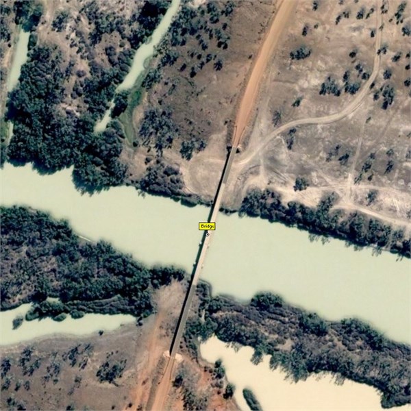
Burke and Wills Bridge
Cheers
Greg
| I sent one final shout after him to stick to the track, to which he replied “All right,” That was the last ever seen of Gibson - E Giles 23 April 1874 Lifetime Member
My Profile My Blog Send Message
Moderator |
FollowupID:
818978
Reply By: Member - Trevor - Thursday, Jun 26, 2014 at 21:48
Thursday, Jun 26, 2014 at 21:48
Hi Simon and Christine The Bullah Bullah crossing is at
S 27 36 46
E 141 04 55
When we were there last year there was a
sign on the northern side of the Cooper indicating it was a road for station use only
We didn't push our luck and try to upset them
It would at least be worth a look from the southern side.
Cheers, Trev
AnswerID:
535059
Reply By: Member - Rod N (QLD) - Friday, Jun 27, 2014 at 13:41
Friday, Jun 27, 2014 at 13:41
Have a look in
Places on ExplorOz,
Bullah Bullah Crossing and also the associated Trek Note.
Lots of good info on ExplorOz.
AnswerID:
535090
Reply By: Member - Ian and Cheryl (QLD) - Monday, Jun 30, 2014 at 21:28
Monday, Jun 30, 2014 at 21:28
S and G
I crossed at the ford last week.
Didn't see any station only signs but there were no Through Road signs on the approaches both sides. I would say that the ford is about 200m north of the edge of the designated
camping zone on the western side of
Cooper Creek. The track on the eastern side is on most maps and just appears to "stop". Incredible rocky paddocks at the
gate near the ford but the crossing is a breeze - a bloke did it in a 2WD Fiat motor home but obviously varies with the
water flow.
Ian
AnswerID:
535281