Normanton to Coen -shortest/best route
Submitted: Wednesday, Jul 16, 2014 at 20:24
ThreadID:
108770
Views:
4472
Replies:
4
FollowUps:
7
This Thread has been Archived
Member - Bill13
We will be leaving
Normanton and going to
Cape York and was after information on the Drumduff and Dixie Road that goes from Dunbar Stn through to Artemis Stn which is about 40klm north of the
Hann River Roadhouse. This shortcut if road conditions are acceptable would save us
miles. I am sure other travellers would have looked at this route, just hoping someone would give us feedback.
We will be towing an off road van as
well and are used to rough conditions.
Bill
Reply By: Member - Frank P (NSW) - Wednesday, Jul 16, 2014 at 20:40
Wednesday, Jul 16, 2014 at 20:40
If you're thinking of crossing the
Mitchell River at Dunbar with a van, I'd suggest think again or investigate. It's a wet sandy crossing, treacherous and there was nothing there to help you choose a line. We were there a few years ago and there was a
sign up - $1000 per recovery with a vehicle on the northern side awaiting customers.
We went further east and crossed at Gamboola.
Cheers
AnswerID:
536163
Follow Up By: Member - Bill13 - Wednesday, Jul 16, 2014 at 20:52
Wednesday, Jul 16, 2014 at 20:52
Frank,
Thanks for your reply. I am thinking and investigating about this route hence the reason for the post.
I did phone Dunbar Stn and they said the crossing was able to be crossed and they have seen a lot of traffic passing through that way but could not comment on the road conditions after that.
I shall have a look at the Gamboola route as an alternative.
Bill
FollowupID:
820236
Reply By: Tony F8 - Thursday, Jul 17, 2014 at 07:03
Thursday, Jul 17, 2014 at 07:03
Bill there is a recently installed plastic crossing across the
mitchell river.
Apparently this has made it a reasonably safe crossing now.
Drive safe.
Tony F8
AnswerID:
536176
Follow Up By: Allan B (Member, SunCoast) - Thursday, Jul 17, 2014 at 08:52
Thursday, Jul 17, 2014 at 08:52
Yes Tony, and here's a picture...........
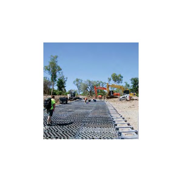
Mitchell Crossing
FollowupID:
820257
Reply By: Member - eighty matey - Thursday, Jul 17, 2014 at 21:31
Thursday, Jul 17, 2014 at 21:31
G'day Bill,
the new crossing just past Dunbar is the go. The roads past there are to be taken steady but it's a good run.
Another option is to go a few hundred kms further east and cross the Mithchell at Gamboola Station. You'll come out at the same place near Dixie OS.
Steve
AnswerID:
536215
Follow Up By: Member - Bill13 - Friday, Jul 18, 2014 at 21:17
Friday, Jul 18, 2014 at 21:17
Hi Steve,
Thanks for your reply. Have you travelled this road recently? How good is your info? I also have heard that it is ok from another source but it was a bit second hand though. It will save about 200klm as against going the Palmerville Road which I know is in reasonable condition.
Bill
FollowupID:
820342
Follow Up By: Member - eighty matey - Saturday, Jul 19, 2014 at 09:46
Saturday, Jul 19, 2014 at 09:46
G'day Bill,
we haven't been that way for 12 months but the tracks/roads are used by the stations so it's usually in good nick.
You could contact Koolatah on (07) 4060 3398 or (07) 4060 3216 to find out more.
Here's a link to
a similar discusson from last year.
Good luck,
Steve
FollowupID:
820350
Reply By: Member - Brad S7 - Thursday, Jul 31, 2014 at 20:34
Thursday, Jul 31, 2014 at 20:34
Hi Bill
Hope you are enjoying your travels, I was wondering if you did venture along the Drumduff and Dixie rd. I intend to travel that way in 3 weeks time , I will be travelling by myself towing a boat and was curious on how that track was and also the crossing at
Mitchell river. Some feed back would be great
Regards
Brad
AnswerID:
536918
Follow Up By: Member - Bill13 - Friday, Aug 01, 2014 at 08:33
Friday, Aug 01, 2014 at 08:33
Hi Brad,
You will have no trouble travelling the Dixie Road towing your boat.
The
Mitchell river crossing is easy but it does have a failed section on the
Normanton side and this is about 700mm deep at its deepest side with about 400mm being the least. No trouble at all. There are several washed out sections on the road towards the middle that requires sensible driving to get through but it is a good shortcut and we had no trouble towing the van.
The road on the PDR side is extra good.
Bill
FollowupID:
821209
Follow Up By: Member - Brad S7 - Friday, Aug 01, 2014 at 21:41
Friday, Aug 01, 2014 at 21:41
Hi Bill
Thanks for replying, approximately how many hours did it take to get to the
river crossing? it's just I won't be leaving
Normanton until after lunch I'm trying to find out if any if there is any good
camping spots near the
Mitchell river away from the crocs of course or closer towards Oroners
Regards
Brad
FollowupID:
821239
Follow Up By: Member - Bill13 - Sunday, Aug 03, 2014 at 12:26
Sunday, Aug 03, 2014 at 12:26
Brad,
Not sure exactly how many hrs it took us to get to the
Mitchell River but we left
Normanton at around 10.00am and got to the
Mitchell River maybe 2-3 PM . Something like that. Good
camping at the MitchellRiver although small in area. Good river, clean fresh
water to drink. Worth a nights
camp there. Check your PM box
Bill
FollowupID:
821321