Road Closed Status map
Submitted: Thursday, Sep 18, 2014 at 07:59
ThreadID:
109540
Views:
2886
Replies:
4
FollowUps:
6
This Thread has been Archived
Member - Woodsy
The site's Roads Closed Status Map shows all major highways in red, i.e. Closed.
What's happening? Are we at War?
Reply By: Rod W - Thursday, Sep 18, 2014 at 09:26
Thursday, Sep 18, 2014 at 09:26
They've done that to confuse the terrorists.
AnswerID:
539240
Reply By: Sir Kev & Darkie - Thursday, Sep 18, 2014 at 10:23
Thursday, Sep 18, 2014 at 10:23
Can you post a link??
I have just checked over 200 roads/highways in the road condition page and all look as they should ie open etc
Cheers Kev
| Russell Coight:
He was presented with a difficult decision: push on into the stretching deserts, or return home to his wife.Lifetime Member
My Profile My Blog Send Message |
AnswerID:
539243
Follow Up By: Member - Woodsy - Thursday, Sep 18, 2014 at 11:20
Thursday, Sep 18, 2014 at 11:20
Hi Sir Kev & Darkie
Go to Treks - Check Road Conditions - Status Map
Double click on map to expand
Voila!
FollowupID:
823848
Follow Up By: Sir Kev & Darkie - Thursday, Sep 18, 2014 at 11:44
Thursday, Sep 18, 2014 at 11:44
Woodsy,
I think it has to do with
EoTopo overlay and those major
routes are not yet reported upon in the Road Condition reports and therefore they are listed as closed as a default.
I know Michelle was looking for more volunteers to increase the number of
routes from the
EoTopo overlay to be converted into segmented road conditions that can then be updated.
Cheers Kev
| Russell Coight:
He was presented with a difficult decision: push on into the stretching deserts, or return home to his wife.Lifetime Member
My Profile My Blog Send Message |
FollowupID:
823849
Follow Up By: ExplorOz Team - Michelle - Thursday, Sep 18, 2014 at 12:31
Thursday, Sep 18, 2014 at 12:31
Whilst we have indeed just gathered a team of volunteers to help with the georeferencing of the roads report, we currently are not using a closed default for the unfinished roads. There is clearly some bug in the tile drawing system as the textual road report is correct for these roads, but the map that extracts this data is showing the wrong colour. David is swamped with trying to close-off data for
EOTopo map production so I have to ask for your patience please as that task is probably going to take priority in the short term and only he can investigate this issue with the roads system. Sorry! Just refer to the text reports for the time being as that is correct.
FollowupID:
823853
Reply By: ExplorOz Team - Michelle - Thursday, Sep 18, 2014 at 12:23
Thursday, Sep 18, 2014 at 12:23
I can't see the problem? I see red, yellow and green roads, not just red. But I did double-click the map to zoom in, as initially when I opened the Status map no roads were showing so I zoomed and then they appeared as they should. I think you might just have some sort of image lag on your browser? But Kev's suggestion above is incorrect, its not a default.
Here's my screen right now....
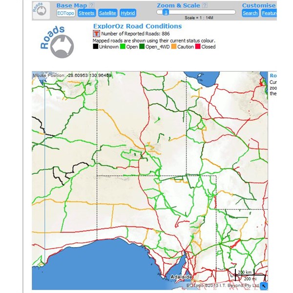
Road Conditions
AnswerID:
539248
Follow Up By: ExplorOz Team - Michelle - Thursday, Sep 18, 2014 at 12:24
Thursday, Sep 18, 2014 at 12:24
Actually, now that I look closer, I see Stuart Hwy red= closed and other main
routes as you say. I will investigate further.
FollowupID:
823852
Follow Up By: fredwho - Friday, Sep 19, 2014 at 23:23
Friday, Sep 19, 2014 at 23:23
I was about to drive across the Nullarbor. Someone let me know when the road is open again.
FollowupID:
823917
Follow Up By: Member - Boobook - Saturday, Sep 20, 2014 at 14:14
Saturday, Sep 20, 2014 at 14:14
The problem is that EO topo also uses Red for main highways. So they look like they are closed.
If you look at any other of the map types they are not shown in red.
FollowupID:
823935
Reply By: Member - Woodsy - Friday, Sep 19, 2014 at 08:13
Friday, Sep 19, 2014 at 08:13
Thank you Michelle
I actually posted this question in the 'Create a Review/Discussion' of 'Contact Us' about 2 weeks ago but received no reply. I then posted it into the
Forum.
It was a bit 'tongue in cheek' but it is interesting to see that Tony Abbott's has taken it quite seriously.
I enjoy ExplorOz immensely and the
Forum with its many questions and comments and the helpful and unhelpful answers. You gotta laugh at how some take themselves so seriously.
Anyhow, you, David and the Team are doing a fantastic job. Thank you!!
AnswerID:
539269