Planning Trip to Israelite Bay
Submitted: Tuesday, Dec 09, 2014 at 16:24
ThreadID:
110374
Views:
5119
Replies:
5
FollowUps:
9
This Thread has been Archived
Stampy4x4
Hi Everyone,
I am planning on heading down to
Israelite bay over the new year.
As i am not too familiar with the area and can't find a huge amount online just wanting to get some opinions on
the spot.
What are the beaches like? i know they won't be as "pretty" as Cape Le Grande etc but surely they are not too bad. Any good fishing?
I've heard there is shelter a couple hundred meters back from
the beach, is it dune cover?
Anyone have any pictures of their trips down that way?
Cheers
Stampy
Reply By: Member - mark D18 - Tuesday, Dec 09, 2014 at 17:12
Tuesday, Dec 09, 2014 at 17:12
I was there about 3 months ago ,Which way are you coming in from. We turned off the at Balladonia and it about a 5 hour drive out to
Israelite bay.
It a rough track and very slow going in sections and as you approach the bay there is a lot of soft sand.
There are plenty of good
camp sites and I would say the fishing would be pretty good.
We were not over impressed , but everyone has an opinion, but in say that we did have it to ourselves.
Enjoy the drive, whatever way you go it is a long slow trip in , but easier from the
Esperance side
Cheers
AnswerID:
542754
Follow Up By: Stampy4x4 - Tuesday, Dec 09, 2014 at 17:22
Tuesday, Dec 09, 2014 at 17:22
Thanks for the reply.
We don't know that either yet. Depending on whether we want to spend New year at
Israelite Bay or in
Esperance.
Our original plans were to
camp at
Lake Johnston just outside of Noresman on night 1 and then head across to Balladonia and down to Israelite from there. Stay there for 3 to 4 nights then head into
Esperance in the new year.
I like the fact there is good
camp sites there. Is there a freshwater source? I read there is a
bore somewhere?
Cheers
Stampy
FollowupID:
829322
Follow Up By: Member - mark D18 - Tuesday, Dec 09, 2014 at 17:33
Tuesday, Dec 09, 2014 at 17:33
Yes there is a fresh
water bore , just near one of the
large camp sites.
I meant to mention there are a lot of corrugations coming in from either end.
FollowupID:
829324
Follow Up By: Stampy4x4 - Tuesday, Dec 09, 2014 at 18:24
Tuesday, Dec 09, 2014 at 18:24
Great! . . Ok thanks for the info mate.
If anyone else has been there i'd love to hear your experiences.
Cheers
Stampy.
FollowupID:
829328
Follow Up By: Member - Warrie (NSW) - Tuesday, Dec 09, 2014 at 19:01
Tuesday, Dec 09, 2014 at 19:01
Hi Stampy, are you in the same rig as in your profile pic? LOL. We did the bay in late April 2013. Lots of pix in
Places. Start with
Israelite Bay Telegraph Station Ruins then
Point Dempster. Click on each place and have a read of the comments for each photo.
We came in From Balladonia towing a camper. It was an enjoyable drive in and we camped along the way. Going out we headed to
Esperance. There were a few flooded sections but we avoided your fate. A supply of fresh
water is available and was offered to us by some campers who go there regularly.
Tons of weed on
the beach but a fun drive to
Point Malcolm... W
FollowupID:
829331
Follow Up By: Stampy4x4 - Tuesday, Dec 09, 2014 at 21:38
Tuesday, Dec 09, 2014 at 21:38
Haha yes still in the Patrol. That was 3 weeks after I got it doing the
holland track :/ 20k on the clock and I stripped the whole interior.
Ah great I'll take a look at those
places.
Is there any
camping spots on
point Malcolm? Or is it better in the bay?
FollowupID:
829344
Reply By: Peter_n_Margaret - Tuesday, Dec 09, 2014 at 20:39
Tuesday, Dec 09, 2014 at 20:39
A few road pics from 2006.
We went in from
Esperance and out to Balladonia towing a boat.
On the way in there were some wet spots, some tidal flats, some sand and some scratchy spots, but no dramas.
We met the other OKA there by chance. Did not see another vehicle.
http://s246.photobucket.com/user/Peter_n_Margaret/slideshow/06%209f%20Israelite%20Bay
Cheers,
Peter
OKA196 Motorhome
AnswerID:
542763
Follow Up By: Peter_n_Margaret - Tuesday, Dec 09, 2014 at 20:44
Tuesday, Dec 09, 2014 at 20:44
There is a
shack there, but I presume it belongs to someone.
The beach was a bit "untidy" with seaweed and we did not fish.
Cheers,
Peter
OKA196 Motorhome
FollowupID:
829336
Follow Up By: Stampy4x4 - Tuesday, Dec 09, 2014 at 21:48
Tuesday, Dec 09, 2014 at 21:48
Ahh great, you towed a bit with not much hassle? I'm the only car not towing a trailer, there's about 4 or 5 others with trailers so that's good to know.
FollowupID:
829345
Follow Up By: rocco2010 - Tuesday, Dec 09, 2014 at 22:01
Tuesday, Dec 09, 2014 at 22:01
Stampy
It's a few years ago but we went down from Balladonia and on to
Esperance in a group with a few trailers.
As others say No real worries but a bit slow in
places.
and the usual provisio that if it has been raining have a plan b
Cheers
FollowupID:
829348
Reply By: mants - Wednesday, Dec 10, 2014 at 01:54
Wednesday, Dec 10, 2014 at 01:54
Hey Stampy, im looking to do the trip from
Esperance out to
Bilbunya Dunes along the beaches etc on the 2nd week in Janurary.
Im going to be going totally solo, so any tips etc from here would be good, measuring online it looks to be about 320km one way.
AnswerID:
542773
Reply By: Member Kerry W (WA) - Wednesday, Dec 10, 2014 at 02:34
Wednesday, Dec 10, 2014 at 02:34
Hi Stampy,
Israelite Bay is a great spot. It has some magic about it but you have to let it ease into you. Finding a
good camp with shade that time of year is essential and you have some choices to find sheltered fishing spots if the winds come up. Be ready for lots of seaweed if you get onshore winds and heavy seas.
Can't lay my hands on my photos of Israelite at the moment but I have some of the dunes and cliffs to the east towards Culver pt. (best reached by the inland track from
Israelite Bay)
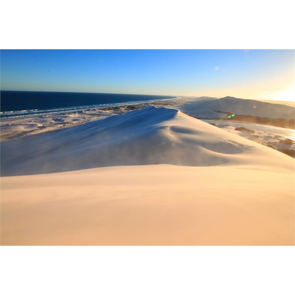
Long Beaches (view from top of Bilbunya Dunes)
There has been good rains there over the last few months so it should look good. The track in from
Esperance is sandy and can be corrugated, traffic since the last rains will have chopped it up somewhat. It is still an interesting drive and certainly part of the overall adventure. The rocky headland has a few good fishing spots, it is worth exploring further east towards the start of the Cliffs of the
Great Australian Bight and
Point Culver - if you have plenty of time. Be aware that the shortcut track out to the highway from the edge of the Cliffs of the
Great Australian Bight is a slow and rocky one about 4-5 hrs to do 80ks. It does improve as you near the Highway. Gettting in from the highway near Balladonia is a bit tricky as the track is marked only by a drum on the side of the road. This track is not on any maps I currently have but I see EOTopos latest update has it marked.
[Image cannot be loaded]
Some Amazing landscapes but pick your weather depending on what you want to do and what you want to see. It will be warm if there is a high over or above the bight but it will not rain. see this Post (109857)
http://www.exploroz.com/Forum/Topic/109857/Best_time_to_visit_Southern_WA.aspx?ky=best+time+to&sn=&p=%2fForum%2fDefault.aspx%3fs%3d1%26ky%3dbest%2btime%2bto%26pn%3d1
Some of the cleanest air in the world down there and many locals marvel at how they can wake up after a hard nights drinking at
Israelite Bay and not be hung over - go figure.
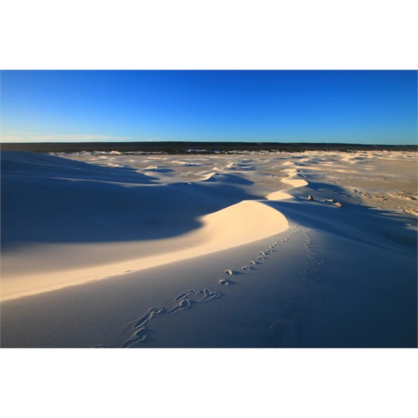
Bilbunya Dune scape east of Israelite Bay
Have Fun
| Kerry W (Qld)
Security is mostly a superstition. It doesnt exist in nature. Life is either a daring adventure or nothing.
-Helen KellerLifetime Member
My Profile My Blog Send Message |
AnswerID:
542774
Follow Up By: Stampy4x4 - Thursday, Dec 11, 2014 at 13:30
Thursday, Dec 11, 2014 at 13:30
Hi Kerry,
Thanks for the reply. I wish we could get up to Pt Culver but i don't think it will happen this time unfortunately. Looking forward to find a good spot to
camp down there and just relax over the new years break.
Cheers
Stampy
FollowupID:
829505
Reply By: Member - Warrie (NSW) - Wednesday, Dec 10, 2014 at 11:46
Wednesday, Dec 10, 2014 at 11:46
Now that there's an audience for this post, why do you think it's called
Israelite Bay? After all it's a long way from the Mediterranean. This reference is from Ron and Viv Moon's book - Across the Bight and Nullarbor. Apparently one of the early
explorers- the Dempster brothers in 1863- noted that the area seemed to mark the
boundary between the Aborigines who were circumcised and those not. To quote Moon - " Think the Bible, The Israelites and you get the connection"................W
AnswerID:
542784