Comment: EOTopo Help and FAQ
Submitted: Saturday, Dec 13, 2014 at 14:16
ThreadID:
110411
Views:
3318
Replies:
2
FollowUps:
13
This Thread has been Archived
Frank P (NSW)
Hi All,
I have a Samsung Galaxy 7.7 tablet (GT-P6800) running Android 4.0.4 (ICS, I think) and a licensed copy of Ozi for Android 1.25. I have many maps at different scales. One of them is EOTopo 2015 available from ExplorOz. All my maps and data reside on an external 32G SD card. This is not a problem with my 4.0.4 version of Android.
My problem is that when changing maps from more detailed to less detailed (eg 25k to 50k to 100k to 200k etc) everything is ok until an EOTopo map (and sometimes other maps) has to be loaded. Then OZI says "Map image not loaded". I can re-load a map using the "Reload recent map" option in the menu and continue on from there until the next EOTopo map (and sometimes others) needs to be loaded, whereupon the problem recurs.
This behaviour is repeatable. It sometimes occurs with maps other than EOTopo, but I cannot establish a pattern. The problem does not occur at all when moving up in map scales - ie from 1M to 250k to 200k to 100k etc.
Trouble is, I installed EOTopo 2015 and the then newly released update to Ozi for Android 1.24 at about the same time, so I cannot determine where the problem might lie. Ozi 1.25 exhibits the same behaviour.
Ozi 1.23 and EOTopo 2014 did not exhibit the behaviour.
I would like to revert to Ozi for Android 1.23 and see if that fixes the problem. But I cannot find a link to the older versions.
If anyone can supply me with a copy of the .apk file for Ozi for Android 1.23 I would appreciate it. Contact me at frankp79 at hotmail dot com. It's only about 4MB so you could possibly email it as an attachment. Or if you know of a link, that would be great.
Cheers
Frank
PS: I have asked the developer of Ozi for help and also sent the above to EOTopo. Just hoping I can get started quickly on investigation with an older version.
Reply By: Idler Chris - Vic - Saturday, Dec 13, 2014 at 14:59
Saturday, Dec 13, 2014 at 14:59
I had a setup the same as yours using an external SD card and had similar problems to yours.
OziExplorer was designed to have sub-directories off the main Oziexplorer directory containing the actual programme, Two sub-directories being "Data" and "Maps". If you keep your data and maps in these directories I believe you will no longer have these problems. I copy these two directories to a SD card on a regular basis.
Your way should work but as you have found out it does not sometimes. Des in programming OziExplorer is a one man band and simply does not have the resources to
test for every single bug. He may get round to it one day but in the meantime best to use the programme as it was designed.
AnswerID:
542943
Follow Up By: Frank P (NSW) - Saturday, Dec 13, 2014 at 16:32
Saturday, Dec 13, 2014 at 16:32
Thanks Chris, nice to know it is not just me. I also found a reference to similar in a
forum after a bit of googling.
Trouble for me is that I can't fit all my maps on the device - they have to go on the external SD card.
I may just have to live with the proble.
You wouldn't have a copy of the v1.23 .apk file would you?
Cheers
Frank
FollowupID:
829698
Follow Up By: Frank P (NSW) - Saturday, Dec 13, 2014 at 16:47
Saturday, Dec 13, 2014 at 16:47
Oh, and here's a screenshot of my folder structure on the SD card. Any clues in there?
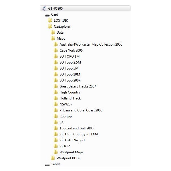
SD Ozi Folder structure
FollowupID:
829699
Follow Up By: Idler Chris - Vic - Saturday, Dec 13, 2014 at 17:13
Saturday, Dec 13, 2014 at 17:13
Sorry Frank do not have a copy of that app.
Another possible solution you could play around with that I believe some have done. Leave all your maps on the SD card. Have a "Maps" directory off your "Oziexplorer" directory on your C: drive. From you SD card copy just the .map files that you want for the trip you are currently doing into this directory. The image files which are the biggest files stay on the SD card as do the original copy of the .map files. I don't think you have to alter the configuration to point at this directory but if it does not work you may have too. This also has the advantage that as you cycle through your maps while you are moving you are excluding maps that you are not interested in.
Might also suggest you put the 5 EOTopo directories as sub-directories of one EOTopo directory, its a tad neater IMHO
Be interested to know how you go. Cheers.
FollowupID:
829703
Follow Up By: Frank P (NSW) - Monday, Dec 15, 2014 at 11:55
Monday, Dec 15, 2014 at 11:55
Thanks Chris,
I did as you suggested with the EOTopo directory. It made the problem worse :-(
But that got me thinking that it may have something to do with too many branches in the folder tree.
So I copied the individual EOTopo files into the parent MAP folder. This undid the "worsening" above, but didn't fix the problem entirely.
BUT, it seems if I am browsing with the GPS off, the problem is worse. With the GPS on so far with those moved maps it seem to be working properly.
So I am going to copy my current SD tree to the PC to keep as a tidy and organised back-up.
And then put every single map file I have into one horrible, unorganised MAP folder on the SD card and see how that works.
Cheers
FollowupID:
829822
Follow Up By: Frank P (NSW) - Tuesday, Dec 16, 2014 at 15:44
Tuesday, Dec 16, 2014 at 15:44
G'day Chris,
I re-did your suggestion with the EOTopo directory, and didn't go ahead with my all-maps-in-one folder proposal.
But I did do some more testing.
Firstly Ozi for Android does not appear to like .bmp files. Some of those were copied over from my PC version and have now been removed from the Android setup.
Secondly, after a fair bit of fooling around, I believe I have found a workaround.
The problems were occurring when I was trying to browse maps with the GPS selected off. Shouldn't be a problem but it appears it was.
When I select the GPS on and let it get a fix, then deselect moving map I can browse up and down through map scales at any location in Australia without a problem.
If I select GPS and try to browse before it gets its first fix the problem recurs. As soon as it gets its fix, the problem goes away.
I've sent this info off to Ozi's programmer, Des
Newman, and also to EOTopo for their info.
Cheers
Frank
FollowupID:
829872
Follow Up By: Idler Chris - Vic - Tuesday, Dec 16, 2014 at 18:35
Tuesday, Dec 16, 2014 at 18:35
Hi Frank, good to see you have solved you problem. I do not have an Android tablet, I have a HP Ultra book running Win 8.1. The screen can be detached from the keyboard and it then becomes a tablet which is great. Up until two weeks ago I found that using in the tablet configuration was not easy in a moving vehicle I found the mouse on the leg much easier that a touchscreen. What has changed is that I caught up with Zebra400 the other day and he showed me how to have the "User toolbar" more useable with a touchscreen in a moving vehicle.
What you do is dock the "User toolbar" down the side of the screen and have fewer buttons but make them bigger. I have the next map up and the next map down as the two bottom buttons (as this is what I do most when moving), this make changing maps while bouncing alone a track pretty easy. I do not know if you already know about this, but if not it is great. Here are a couple on screen shots.
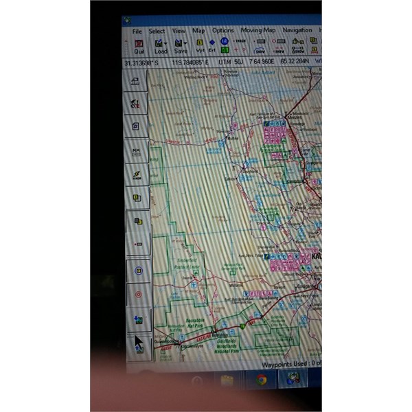
Note toolbar down left side
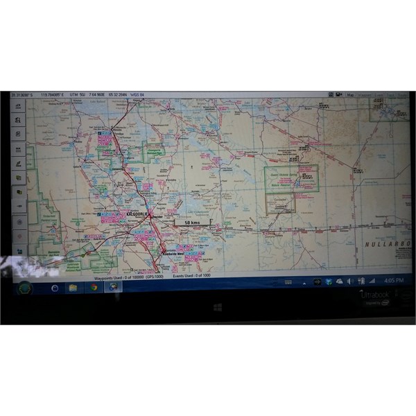
Whole screen
FollowupID:
829886
Follow Up By: Frank P (NSW) - Wednesday, Dec 17, 2014 at 11:05
Wednesday, Dec 17, 2014 at 11:05
Chris,
David at ExplorOz has developed large buttons for Ozi for Android. This is how they look on a 7.7 inch screen.
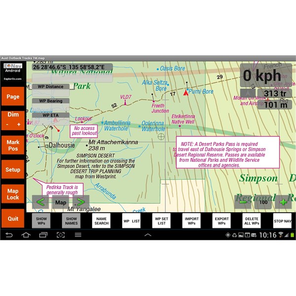
Waypoints screen
There are 6 layouts to choose from, each having buttons most appropriate for the chosen task.
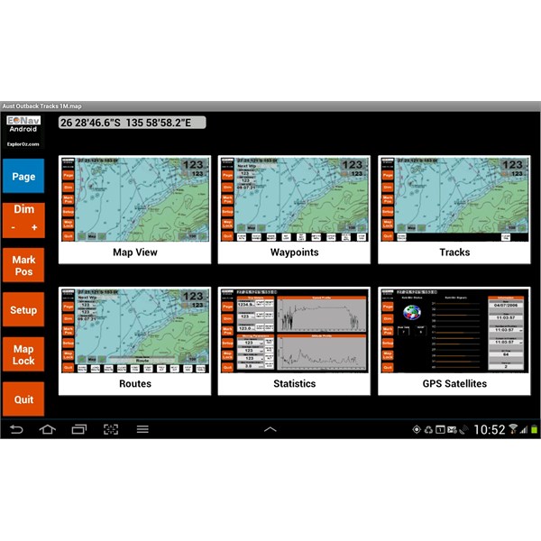
Page screen
They were designed using Ozi's Screen Designer for Android - a PC program that outputs screen layout files fo Ozi for Android. I've tweaked them a bit to suit my preferences.
Cheers
FollowupID:
829920
Follow Up By: Idler Chris - Vic - Wednesday, Dec 17, 2014 at 15:34
Wednesday, Dec 17, 2014 at 15:34
Gee wiz Frank you have just cost me money. I have heard that the android version is pretty good but never seen it, now I have to have one. Cheers
FollowupID:
829954
Follow Up By: Zebra400 - Wednesday, Dec 17, 2014 at 15:43
Wednesday, Dec 17, 2014 at 15:43
Where have you been looking Chris? I have my Android tablet on the
table at TLCCV meetings. Surely you have seen it on my
table or even in my 4WD!!
FollowupID:
829957
Follow Up By: Frank P (NSW) - Wednesday, Dec 17, 2014 at 16:35
Wednesday, Dec 17, 2014 at 16:35
Sorry Chris :-)
I really like it. The MAP button gives you a list of maps available at your present location.
The buttons either side allow you to move up and down maps scales at your present location, while the "minus", "100" and "plus" buttons just zoom the current map.
I find it incredibly useful. I can have a bigger map to keep an eye on the overall big picture, but if there's a tricky turn required, or a need for more detail, just use the > button to get a map with greater detail and then the < button to return to the big picture.
I somes run my street navigator (CoPilot Live) in the background. It has the best coverage of tracks and firetrails of any turn-by-turn navigator that I've seen, but no topographic detail. So when it says "turn right in 1km" I can see on OZI (which is in the foreground and has the focus) what it means and where it intends to take me.
I am experimenting with planning, creating tracks and routes on the PC and transferring them to the tablet. Have a big trip coming up next year so need to be ready for that.
Cheers
FollowupID:
829963
Follow Up By: Idler Chris - Vic - Wednesday, Dec 17, 2014 at 17:23
Wednesday, Dec 17, 2014 at 17:23
Hi Zebra, I know you rave about how good the android version is, but as I have a windows setup I have not taken a lot of interest in it. I think I am right in saying you use both so I may end up doing the same. Cheers.
FollowupID:
829964
Follow Up By: Idler Chris - Vic - Wednesday, Dec 17, 2014 at 17:42
Wednesday, Dec 17, 2014 at 17:42
Hi again Frank,
In relation to your trip planning. If you are planning to go to remote
places this is what I do. In remote
places the tracks shown on maps are usually not all the tracks that are there. I use Google Earth to follow the path I want to follow and waypoint with directions the track intersections, POI's etc. You save this as a kml file which you then import into OziExplorer and save with you other waypoints. Then when you are in the middle of nowhere and come to an
intersection not on your maps you know where to go. You need to be mindful though that Goole Earth images can be years old and things can change, paticularly if you are in an area where there mining operations. Just this year a group of us was driving on the Nippon Highway in the Great Victorian Desert in WA (which is at best a 4wd track) and thought we where
miles from anywhere. Then while we were stopped for a break we could here truck engines getting louder and louder. Then through the trees we saw 3 road trains travelling at some 80 kmh on a new mining road not 50 metres away.
FollowupID:
829966