Gunbarrell closure?
Submitted: Monday, May 04, 2015 at 21:02
ThreadID:
117732
Views:
3243
Replies:
4
FollowUps:
14
This Thread has been Archived
Sapper D
G,Day members,
Have been told that a section of the Gunbarrell Hwy from
Jackie Junction to Mt Samuel has been closed, Any forumites know whether this is true or not, if so why ?
Cheers all.......Sapper D
Reply By: equinox - Monday, May 04, 2015 at 21:39
Monday, May 04, 2015 at 21:39
Hi Sapper,
There's a
sign at
the Junction saying so, I'm pretty sure if you apply through the normal channels it will be OK though.
I think the
sign is more of a general
warning sign, not a true road closure in the normal sense.
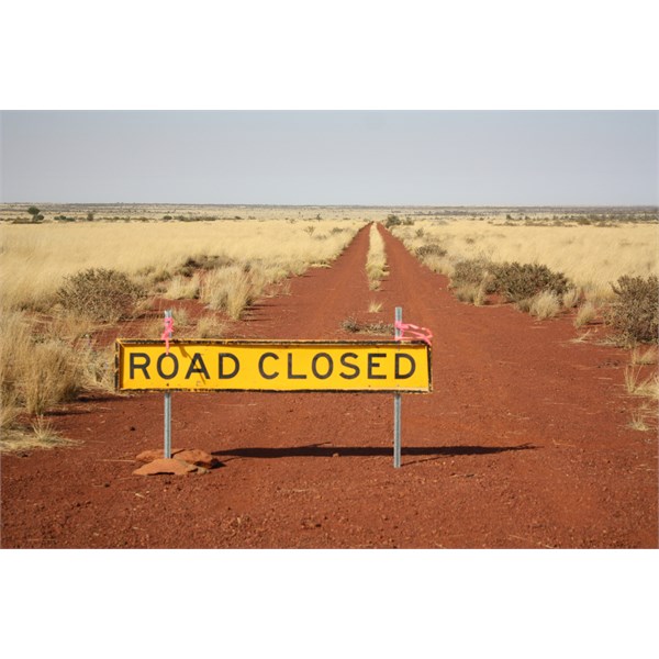
Sign
AnswerID:
553321
Follow Up By: Shaker - Monday, May 04, 2015 at 21:55
Monday, May 04, 2015 at 21:55
Warning against what & what is the true sense of a road closure?
As far as I can see there are only 2 words on the
sign, so it shouldn't be too hard to understand!
FollowupID:
839139
Follow Up By: equinox - Monday, May 04, 2015 at 21:57
Monday, May 04, 2015 at 21:57
Typical pathetic negative response that I would expect from you Shaker
FollowupID:
839140
Follow Up By: Bigfish - Tuesday, May 05, 2015 at 07:35
Tuesday, May 05, 2015 at 07:35
I would say
road closed. You will always get the know all fools who will ignore these signs. It is not a
warning sign at all, the same as a stop
sign is not a "slow down, you,ll be right"
sign. It is clear in its message. The idiots who ignore it and drive on regardless are the ones who see all travellers tarred with the same brush. Now it could have been put there by local indigenous mob for ceremonial reasons. Often happens out bush. Could have been put there by coppers following up on a crime. Council may have put it there for the road being impassable.
Couldn,t get a clearer message IMHO.
FollowupID:
839144
Follow Up By: Shaker - Tuesday, May 05, 2015 at 09:27
Tuesday, May 05, 2015 at 09:27
Equinox, you obviously subscribe to the theory that attack is the best form of defence.
Are you also going to attack Bigfish for his response?
The sooner people realise that road signs mean what they say the better.
FollowupID:
839146
Follow Up By: equinox - Tuesday, May 05, 2015 at 09:30
Tuesday, May 05, 2015 at 09:30
You're a troll Shaker, do me a favour and never reply to one of my followups again.
FollowupID:
839147
Follow Up By: Hairy (NT) - Tuesday, May 05, 2015 at 10:06
Tuesday, May 05, 2015 at 10:06
To equinox's defence, he did say
"I'm pretty sure if you apply through the normal channels it will be OK though"
Not to ignore the
sign and drive straight through.
Occasionally signs like this are put up for a short term reason and forgotten. So ringing the people involved as suggested would be the best idea.
Cheers
FollowupID:
839148
Follow Up By: Allan B (Member, SunCoast) - Tuesday, May 05, 2015 at 10:36
Tuesday, May 05, 2015 at 10:36
The 'track' from Warakurna to
Jackie Junction is known variously as the "Old Gunbarrel Road", the "Abandoned section of the Gunbarrel Highway", and the "Closed section of the Gunbarrel Highway". It is a section of the original
Gunbarrel Highway.
It is not "closed" in the sense of a
road closed by the Shire as being unsafe, impassable etc. but can be travelled with a permit obtained from the Ngaanyatjarra Land Council. You are required to declare that you are travelling at your own risk and may be required to obey conditions such as companion travelling and communications. Permits are not necessarily granted.
I certainly would not access this road without the appropriate permit.
I have travelled this section with permit and in company several years ago. It is interesting but the track is rough and has numerous
washouts that require a keen eye to avoid. I would not wish to travel on it if at all wet.
FollowupID:
839152
Follow Up By: Shaker - Tuesday, May 05, 2015 at 15:52
Tuesday, May 05, 2015 at 15:52
I actually followed up your reply, which I will do whenever I wish to, unless the moderators advise me otherwise!
FollowupID:
839170
Reply By: Member - Boobook - Monday, May 04, 2015 at 22:01
Monday, May 04, 2015 at 22:01
I don't think you will get access to that section of Road. It is marked on the permit map of the Ngaanyatjarra Council as Closed to the Public, it's the only one so marked. I think you may have to go via
Warburton.
Call Nicole Warren of the Ngaanyatjarra Council on 08 89501711. I am sure she can help you. She is very responsive and really helpful with permit stuff. Excellent service.
AnswerID:
553322
Follow Up By: Allan B (Member, SunCoast) - Tuesday, May 05, 2015 at 15:08
Tuesday, May 05, 2015 at 15:08
Hi Boobook,
You and I seem to get differing outcomes on this.
My examination of the permit map of the Ngaanyatjarra Council shows the "Old Gunbarrel" as being available to permit application. See the screen grabs below. The only one noted as being "Not Open to PU" is the un-named track between
Jackie Junction and the Heather Hwy coloured in black. Some of the colours do not match from the map to the list.
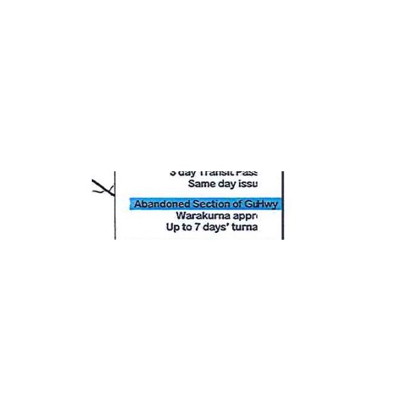
Old GBH
Old GBH 2
FollowupID:
839163
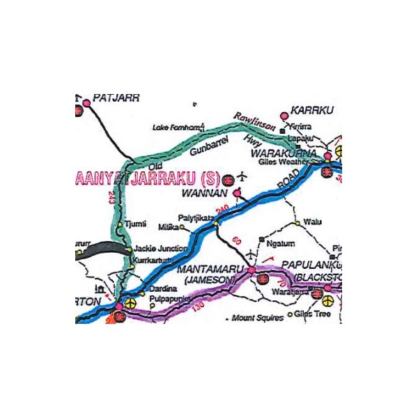
Follow Up By: Member - Boobook - Tuesday, May 05, 2015 at 16:15
Tuesday, May 05, 2015 at 16:15
Allan that map looks the same as the one I have.
The Black road runs west from
Jackie Junction to Mt Samuel via Mt Charles / Rorurr(?). It says
Jackie Junction to Gun Barrell Hwy CLOSED TO PUBLIC on the map.
That is the section the OP is asking about as far as I understand.
FollowupID:
839171
Follow Up By: Allan B (Member, SunCoast) - Tuesday, May 05, 2015 at 17:14
Tuesday, May 05, 2015 at 17:14
Yes Boobook, I think you are correct in the section that the OP is asking about. I did not know "Mt Samuel" and could only see "Mt Charles" on my Hema map. You may see my confusion! I retract everything.
I don't even know if I have travelled on the section in question.
The Ngaanyatjarra map I referred to is
this one but I'm damned if I can find any road with the notation of "CLOSED TO PUBLIC" anywhere on the map. Perhaps I am blind! lol
Should you find me wandering aimlessly out there please pick up my white cane and gently reorient me.
FollowupID:
839177
Follow Up By: rocco2010 - Tuesday, May 05, 2015 at 17:41
Tuesday, May 05, 2015 at 17:41
Giddy
How old is your map? it is my understanding that this travel restriction is relatively recent, like the last couple of years so may not have made it on to some maps.
I certainly knew of it from doing some research for permits in recent times.
Cheers
FollowupID:
839178
Follow Up By: Member - Phil G (SA) - Tuesday, May 05, 2015 at 20:04
Tuesday, May 05, 2015 at 20:04
The restriction was in place in 2005 when I last travelled that way.
FollowupID:
839192
Follow Up By: Member - John Baas (WA) - Tuesday, May 05, 2015 at 20:46
Tuesday, May 05, 2015 at 20:46
Hi all.
We travelled it in Sept 2012 as a single vehicle with CT. Track was a bit agricultural but I wouldn't class it as difficult - about the same as, say, the upper Connie Sue.. There's some nice scenic country incl some wonderful Desert Oak groves; as good as the Sandy Blight Jnctn track. At no time did we have probs towing the CT. Be different if wet but...
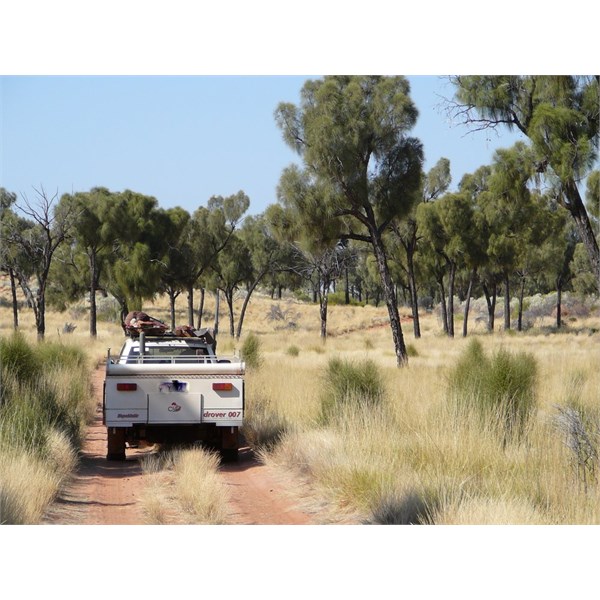
Old GB Hwy - Desert Oaks
We had received a permit via a Desert Discovery program. My understanding is that permits are generally issued but a minimum of two vehicles is required in 'normal' circumstances.
Easy way to find out - apply for a permit...
Cheers.
FollowupID:
839195
Reply By: Member -Ted (Vic) - Tuesday, May 05, 2015 at 15:03
Tuesday, May 05, 2015 at 15:03
Hi Sapper
Did it last year with 4 vehicles and permits, good drive. Permits weren't to hard to get from memory. We had the required number of vehicles and communications gear (sat phone and
hf radio).
Cheers
AnswerID:
553346
Reply By: TrevorDavid - Tuesday, May 05, 2015 at 16:11
Tuesday, May 05, 2015 at 16:11
Sapper,
Travelled the Gunbarrell last July. No permit was issued for the
Jackie junction to
Heather Highway section Paperwork stated that permits were no longer issued for this section.
Regards
TDB
AnswerID:
553353