Old Coach Road Relevance and History
Submitted: Wednesday, May 27, 2015 at 20:34
ThreadID:
119007
Views:
6319
Replies:
7
FollowUps:
3
This Thread has been Archived
Member - Laurie K (WA)
I wonder if anyone can give me any idea as to the relevance and importance of the Old Coach Road, which runs eastwards along the top of the Hampden Range on the Nullarbor.
Whilst filming along the Trans Line recently, I was fortunate to speak with local historian, Jill Campbell from Kybo Station. Researching the next part of our story, I asked her about the Old Coach Road, and she told me that she had never seen evidence that the road was ever used as a regular route.
I subsequently purchased a copy of a book called “The Overlanders - Crossing the Nullarbor - 1870s-1970s”, which is a 300 page A4 collation of newspaper items and travellers own stories from the period.
There is no account that indicates that anyone took that road. With the advent of the Overland Telegraph Line, travellers either followed the original line from
Esperance and
Israelite Bay, or travelled via Frazer Range and the new Balladonia Telegraph Station to
Madura Pass, where they descended to Madura Station, then followed the Telegraph Line along the bottom of the scarp to
Mundrabilla Station before reaching
Eucla.
The Eyre Hwy was built in 1942 following that same course.
So the question is, what is the relevance of The Old Coach Road, and have Hema got it wrong with their mapping description?
Reply By: Member - John - Thursday, May 28, 2015 at 05:26
Thursday, May 28, 2015 at 05:26
Laurie, maybe ask HEMA the question, they maybe able to shed some light on your query. Good luck.
AnswerID:
554322
Reply By: Member - Rod N (QLD) - Thursday, May 28, 2015 at 17:42
Thursday, May 28, 2015 at 17:42
The 'Old Coach Road' on the
HAMPTON Tableland is also shown on the EO Topo 200K map.
Old Coach Road
AnswerID:
554338
Follow Up By: Member - Laurie K (WA) - Thursday, May 28, 2015 at 18:26
Thursday, May 28, 2015 at 18:26
Yes Rod, it is. (yes, I did get that wrong - posted before I corrected it). However, Hema state on their GDT Maps, that "Travellers originally crossed the Nullarbor in Horse Drawn coaches along this road", and there appears to be no evidence to support this.
I have sent Hema an email (limited by their 512 character requirements) asking if they can explain the relevance of the road. I am eagerly awaiting their reply.
I did wonder whether it was originally a stock route, but again, it would appear that stock was taken down onto the plain where there was plenty of grass for grazing on.
It would appear from my conversation with Jill Campbell, that local station lessees are not convinced that it is as claimed.
For people who are interested in the history of the Nullarbor (including The Overlanders) and other Australiana stories, Hesperian Press is a great place to start. Jill Campbell has written a couple of books - "Verse from The Nullarbor", and "Ted And Mary Mac" - They were her parents and started the
Cocklebiddy Roadhouse in 1957.
FollowupID:
840403
Reply By: Member - John - Thursday, May 28, 2015 at 21:38
Thursday, May 28, 2015 at 21:38
Laurie, just had a thought, maybe Westprint in Nhill may know something about it.
AnswerID:
554350
Reply By: Dr Hook - Friday, May 29, 2015 at 11:55
Friday, May 29, 2015 at 11:55
Laurie;
Coaches require horses which require watering points: there's plenty of rock-holes along that track, so one would assume the coaches would travel where the
water is. It is not so far from the road that the roadmakers would have described their work as "following" the
old road, just a re-alignment to take advantage of flatter ground.
Dr Hook
AnswerID:
554364
Follow Up By: Member - Laurie K (WA) - Friday, May 29, 2015 at 12:20
Friday, May 29, 2015 at 12:20
Yes Doc, that all makes sense, however, there is no evidence that coaches actually travelled that road. Coaches were replaced by motor vehicles around the turn of the century, and there is plenty of documentation about their exploits. There was no formed road, and the telegraph line was the route followed, as the government had placed a number of tanks along the route. The Old Coach Road runs along the top of the scarp, where the track descended to the plain at Madura - altho the descent would not have been suitable for coaches by all accounts, or would have been a coach breaker - remember no road was formed at that point until 1941. The telephone line followed the bottom of the scarp from Madura to
Eucla, and there was plenty of grass for feeding stock, as
well as the afore mentioned tanks.
FollowupID:
840453
Reply By: Member - Laurie K (WA) - Friday, May 29, 2015 at 12:21
Friday, May 29, 2015 at 12:21
I have today received this email from Hema.
"Thank you for your query.
The owner of the property that 'The Old Coach Road' runs through called us last year and asked if we could remove the name and put note for people to ask for permission to travel here. The owner said the same thing, that as far as he is aware that no coach ever followed that route.
The name will be taken off the relevant maps as they are updated. The original information would have come through in the data from Geoscience Australia.
Sales Support
Hema Maps"
cheers
Laurie
AnswerID:
554365
Reply By: Idler Chris - Friday, May 29, 2015 at 12:31
Friday, May 29, 2015 at 12:31
Hi Laurie, I remember that we spoke about this road awhile back and I cannot remember whether you drove it or not. Below is the
sign and
gate at the start of the "Old Coach Road" from Madura. I drove this road in 2013 from Madura as far as the
Eucla Reid Road and the
EOTopo map is very accurate. I have a plt file if anyone is interested. The balance of this road past Wabia
Cave to Coompana
Tank is unfinished business, expect to do it next year. Cheers, Chris
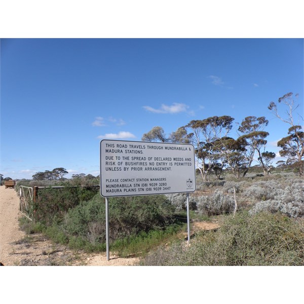
Sign at start of Old Coach Road Madura
| What other people think of me is none of my business.
Do unto others what you would have them do unto you.
The word "hate" is not in my vocabulary. Lifetime Member
My Profile My Blog My Position Send Message |
AnswerID:
554367
Follow Up By: Member - Laurie K (WA) - Friday, May 29, 2015 at 14:31
Friday, May 29, 2015 at 14:31
G'day Chris
No, I didn't get that far. I travelled from
Haig to Cocklebiddy, then back home as the railway section of my project was finished.
We are planning the second part for September, and the Old Coach Road was in consideration. However, after talking to Jill Campbell, and reading the accounts and therefore history in "The Overlanders", I have shifted my research to maybe following the western part of the OTL from
Esperance, and then picking up the Old Eyre Hwy and environs. There is much
water to flow under the bridge.
I enjoyed talking to you. Thank you for your input.
cheers
Laurie
FollowupID:
840461
Reply By: equinox - Friday, May 29, 2015 at 20:43
Friday, May 29, 2015 at 20:43
Hi Laurie,
I had a bit of a look around my sources - I haven't delved that much to be honest however at least three rockholes on that old track were named by Surveyor GR Turner in 1885.
Cheers
Alan
AnswerID:
554410