Bullo Development Road / Adventure Way
Submitted: Monday, Sep 28, 2015 at 07:41
ThreadID:
130430
Views:
4664
Replies:
4
FollowUps:
14
This Thread has been Archived
Les - PK Ranger
Hi all.
Going to be driving
Brisbane to Innaminka in ~ a month, and just wanted to plan travel times appropriately on the road through
St George,
Cunnamulla,
Thargomindah, and beyond.
Google shows pretty much bitumen to
Thargomindah, then looks like dirt most of the remaining way . . . but I travelled Bris to BV via
Roma,
Charleville,
Windorah a couple of months back, and where Google showed dirt on a lot of sections, it had in fact been sealed, although crudely in
places.
So, for those in the know with recent travels, after
Thargomindah has there been much work done sealing on Adventure Way ?
I recall in April 2014 on a B&W dig tree visit from Inna, there was some blacktop out that way (good stuff too !!), but not sure how far it extends back towards
Thargomindah.
Thanks in advance for any input.
Feel that with 0200 start, I can
camp Cullyamurra with careful driving in the wee hours with animals, and make the 1360 odd km by late arvo / dusk on the
waterhole.
Might have back up driver, if a mate flies up to join me for Simmo run back to
Adelaide.
Reply By: Nomadic Navara - Monday, Sep 28, 2015 at 08:14
Monday, Sep 28, 2015 at 08:14
I have just had a look at Google maps and noted there is no street view out where you are talking about. Use the Hema street atlas for road surfaces, it's more accurate. If you get a copy (8th edition) of Camps Australia Wide it has the latest edition of Hema in it as its maps. You will get two useful editions in one book.
As of a couple of months ago the Science Loop (
the loop road from
Cunnamulla to
Charleville) was all sealed. Some of it was slimline road. The road from the western end of the Science Loop to Innaminka is mostly sealed. There is a 17 km stretch in the middle that looked like they were resealing it. The final bit from the
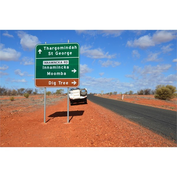
SA border is reasonable gravel surfaced road. The road into
the Dig Tree is mostly natural surface, the only bit that had to be careful on was the first
creek crossing.
AnswerID:
590813
Follow Up By: Les - PK Ranger - Monday, Sep 28, 2015 at 08:26
Monday, Sep 28, 2015 at 08:26
Thanks Peter, I was using Google maps sat view, zoomed in where needed, shows blacktop pretty
well.
Will see if any recent travellers have any feedback on the road surface
Thargomindah to Innaminka, otherwise I'll just plan for dirt and 80km/hr avg on the 360km from Thar to Cullyamurra, might get lucky in sections again.
Yes I recall the Inna to Cooper bridge near B&W dig tree turnoff was pretty good, great dirt to the
SA border, then pretty much bitumen from near QLD border out past the bridge if I remember right.
That was 04/14.
FollowupID:
858870
Follow Up By: Member - Alan H (QLD) - Monday, Sep 28, 2015 at 09:12
Monday, Sep 28, 2015 at 09:12
It is bitumen from the
SA border to
Brisbane
Alan
FollowupID:
858871
Follow Up By: baznpud (tassie) - Monday, Sep 28, 2015 at 09:13
Monday, Sep 28, 2015 at 09:13
We travelled from
Thargomindah to Innaminka back in 2013, road was sealed to the
SA border, from there at that time it was unsealed.
baz
FollowupID:
858872
Follow Up By: Les - PK Ranger - Monday, Sep 28, 2015 at 09:18
Monday, Sep 28, 2015 at 09:18
Awesome news Alan and baznpud, thanks . . . sort of had an inkling it might be sealed now, so although narrow in
places, should allow for a decent run at speeds to suit all conditions / traffic.
Many thanks again.
FollowupID:
858873
Follow Up By: Nomadic Navara - Tuesday, Sep 29, 2015 at 01:03
Tuesday, Sep 29, 2015 at 01:03
"Member - Alan H (QLD) posted:
It is bitumen from the
SA border to Brisbane"
Alan, they have finished that 17 km stretch in the middle that I referred to have they?
FollowupID:
858910
Follow Up By: Nomadic Navara - Tuesday, Sep 29, 2015 at 01:10
Tuesday, Sep 29, 2015 at 01:10
Les, I don't think you picked up what I was describing -
This is the Science Loop. - You can see where the Innaminka road takes off from the western end just north of Noccundra.
FollowupID:
858911
Follow Up By: Les - PK Ranger - Tuesday, Sep 29, 2015 at 07:32
Tuesday, Sep 29, 2015 at 07:32
Yeah sorry Peter, I did sort of pick that up and did that little bit from that SW corner on Adventure Way to
the dig tree turn in 2014, it was unsealed then from memory.
FollowupID:
858912
Reply By: Member - Stephen L (Clare SA) - Monday, Sep 28, 2015 at 14:28
Monday, Sep 28, 2015 at 14:28
Hi Les
I can only comment on the Adventure Way from
the junction of the Cooper Developmental Road, as we came in from
Eromanga.
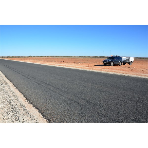
We were through there in late June this year and it is a very good run, with the bitumen ending just before the South Australia/Queensland Border. We only came across on section of road that was being repaired.
We went into
the Dig Tree site from the Adventure Way and came out the next day on a shortcut that saved us over thirty kilometres.
Cheers
Stephen
I can only comment from this junction with the Cooper Developmental Road
This is where we rejoined the Adventure Way from the Dig Tree shortcut

The bitumen ends before the state border
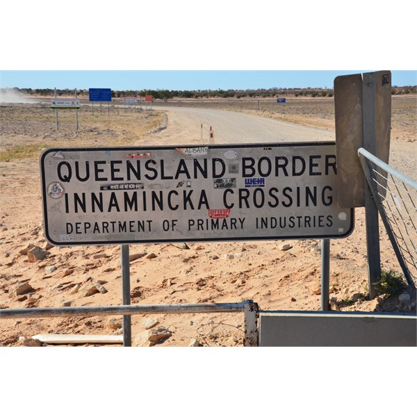
This Grid is the state border
AnswerID:
590824
Follow Up By: Les - PK Ranger - Monday, Sep 28, 2015 at 15:05
Monday, Sep 28, 2015 at 15:05
Cheers Steven.
Was the shortcut from
the dig tree that little track on the south side of the Cooper, accessed by the ford (Bulla Bulla Crossing on the 250k topo) ??
I was contemplating
camping there, and looked at that wonderiong if gated / private station track . . . both myself and possible pax visited
the dig tree site in 04/14, and really like Cullyamurra anyway, so might just aim for the bit further along, and have a nice Walkers X run to
Warburton River next day.
Thanks again.
FollowupID:
858886
Follow Up By: Member - Stephen L (Clare SA) - Monday, Sep 28, 2015 at 20:33
Monday, Sep 28, 2015 at 20:33
Hi Les
The shortcut is dead easy to find, and will give you a run down now.
At
the Dig Tree site, it is only the very modest fee of $11, which covers entry into the site, and if you want to stay and
camp, from one day to a week, the entry fe covers the
camping as
well.
There are many fine spots along this section of Cooper and "Duck" the caretaker / manger is a great guy to chat with.
As you drive in to the
camping area, just keep following this track and you will go through 2 channels of the Cooper, both firm and rocks and then keep following the track. There is only one
gate, that is not locked not far from where you join the Adventure Way.
The only trouble with the areas inside the Regional Reserve, the fees were from memory $18 per night if yo do not have
the Desert Parks Pass.
Cheers
Stephen
FollowupID:
858902
Follow Up By: Les - PK Ranger - Tuesday, Sep 29, 2015 at 07:42
Tuesday, Sep 29, 2015 at 07:42
Cheers Stephen, we'll see how time is going . . . if running a bit behind and getting dusky, I might look at
camping there, either entering the normal way from north side of Cooper and past Nappa M, or taking the turn from Adventure Hwy to the Cooper ford and cross and enter the
camping area from there.
No real advantage taking the southern ford entry travelling from the east when going in there, heading out next morning though would save a fair bit of track / time, roughly 1/4 the distance to the same Adventure Hwy spot.
Never saw anyone there on our brief visit 04/14, would like to meet Duck and say g'day.
We spend an hour or so there late one arvo, before completing the little loop back to Cordillo Rd, then back through Inna to
camp Cullyamurra.
I do recall I liked Cully
camping better than
the dig tree site (looked), but there would be a bit of nostalgia
camping there, and not too far extra to pick up next day to
Warburton.
Have a parks pass so all good there :)
This trip will spread this years cost to 3 Simmo crossings :D
FollowupID:
858913
Reply By: rumpig - Monday, Sep 28, 2015 at 17:55
Monday, Sep 28, 2015 at 17:55
2 years ago it was bitumin all the way to
Thargomindah from
Brisbane, then mostly bitumin all the way from
Thargomindah to
the Dig tree turn off / S.A border. There was a small section about 10 -15 klms long near
the Dig Tree end that was dirt, but it turns back to bitumin before you reach that
intersection. Not sure if that small section of dirt is now bitumin or not, but it was a good dirt road section non the less back then. From the S.A border it turned to dirt, a pretty ordinary road from there into
Innamincka it used to be, can't help with current conditions though.
We needed to get to Thargo from
Innamincka to get parts before Toyota closed on our last visit, managed the drive in a touch over 3 1/2 hours (we may have been speeding a touch though, but made it just before closing time), the trip back in the dark that night dodging cows and roos took a couple of hours longer. Don't let the lack of roadkill between
Thargomindah and
Innamincka fool you into thinking there's not much out there to hit at night, it's only lacking due to the fact nobody is driving around there at night time, we didn't see another vehicle for the first 3 hours of the return run that night, and only a few all up from the gas fields on the entire journey back to
Innamincka.
AnswerID:
590828
Follow Up By: Les - PK Ranger - Monday, Sep 28, 2015 at 18:16
Monday, Sep 28, 2015 at 18:16
Ta Rumbo, seems pretty good feedback all round in the thread, a couple on 4x4 Earth members also said it's a breeze, a bit boring actually, but hey, have to get there somehow, and I love to drive :)
I'll leave Brissy 0200 and do most of the dark driving that side, will still have to be careful going through
Toowoomba -
St George -
Cunnamulla etc, suppose like most outback night drives, roos will either be out there in the hundreds, or almost non existent.
I reckon we'll get in to Cullyamurra by 1700 or so, in time to get a fire going and some tucker, read for a good nights sleep.
FollowupID:
858894
Follow Up By: rumpig - Monday, Sep 28, 2015 at 19:01
Monday, Sep 28, 2015 at 19:01
I just drove out to
Nindigully on Friday with the misses for the weekend to catch up with some mates, plenty of dead roos to be seen after Gundy going that way which would be my choice (had a few roos try to commit suicide with me also in the middle of the day). The Moonie Hwy is a shocker if you go via
Dalby IMHO, it's worse then a rollercoaster ride with
the humps and bumps on it. Took me 6 hours just cruising along on the speed limit with our camper trailer on the back to get to
Nindigully from
Brisbane, stopped for morning tea at Inglewood and a few other quick leg stretch /
toilet stops along the way also, aswell as fueling up at
Aratula along the way first up.
FollowupID:
858895
Follow Up By: Les - PK Ranger - Monday, Sep 28, 2015 at 19:21
Monday, Sep 28, 2015 at 19:21
We'll be not too far north of
Nindigully, 5.5hrs pretty normal run from there to Brissy, depending on where in town and traffic conds.
Thanks for the tips on
Dalby - Hwy 49 Moonie, that's the way recommended as fastest via Mr Google.
The Rangers not too bad with undulations and will have a fairly light load this time.
FollowupID:
858897
Reply By: craigandej - Tuesday, Sep 29, 2015 at 17:30
Tuesday, Sep 29, 2015 at 17:30
Came through from
Innamincka to
Ballina last year with one overnight at
Cunnamulla. Road sealed from Dig Tree all the way home. Great road no traffic. Watch out for emus.
Cheers
AnswerID:
590860
Follow Up By: Les - PK Ranger - Tuesday, Sep 29, 2015 at 17:34
Tuesday, Sep 29, 2015 at 17:34
Thanks Craig, and will be very mindful of roos and emus, especially so in the 5 or so first hours driving (2-7), and towards the end of the day.
The big birds can be very erratic, moreso than roos I have noticed.
FollowupID:
858938