Digital Navigation
Submitted: Tuesday, May 24, 2016 at 19:59
ThreadID:
132516
Views:
4138
Replies:
6
FollowUps:
7
This Thread has been Archived
beach40
So I'm about to set out on a drive from
Canberra to
Darwin and figured it would be good trip to get into electronic navigation devices.
It seems Hema maps are the go. I don't have a tablet device, so can I buy the Hema Raster maps DVD and use it on my laptop?
Later when I do get a tablet device, can I then load these raster maps onto it and use the GPS function?
Or maybe I have this all wrong?
Reply By: Michael H9 - Tuesday, May 24, 2016 at 20:17
Reply By: Member - Will 76 Series - Tuesday, May 24, 2016 at 21:12
Tuesday, May 24, 2016 at 21:12
Beach, my thoughts are that tablets and Laptops take up a lot of room in the front of the vehicle. I would cut to the chase and buy the Hema HN7 7 inch GPS and load it up with maps. You can still do all your planning on a laptop and then load way points & POI's to your GPS. I run a Garmin by the way but the Hema HN7 is probably the most used GPS on the market and gives great detail plus easy to use.
AnswerID:
600525
Follow Up By: Sigmund - Wednesday, May 25, 2016 at 05:07
Wednesday, May 25, 2016 at 05:07
There may be enough detail in the Hema set to meet the original OPer's needs but they are small to medium scale and so not especially detailed.
Bottom line is to inspect some map samples from various producers to see if they'll do what you need.
FollowupID:
869900
Follow Up By: spanner1969 - Wednesday, May 25, 2016 at 08:31
Wednesday, May 25, 2016 at 08:31
Beach I agree with Sigmund,
I have the Hema HN7, for some years now, on and off road its awesome, and have travelled with it everywhere, Cape,
Vic High country etc and on road application is very useful also.
The tablet/laptop was as mentioned way to big for the dash/vehicle and does up a lot of room.
food for thought
Spanner
FollowupID:
869905
Follow Up By: Member - Mark E (VIC) - Wednesday, May 25, 2016 at 14:40
Wednesday, May 25, 2016 at 14:40
I went half way and purchased a 'small' 7" tablet. Similar to an iPad mini. This to me, is the perfect size and will do a great number of other things than will the HN, including email, internet + 1000's of other 'apps', many of which can be very useful for travelling, i.e. Wiki Camps, Fuel calculators etc...
The tablet cost just a fraction of what a HN costs and is just so much more versatile. I like to have items that serve multiple purposes with me when I travel to cut down on the crap and weight I carry.
Worth a look.... with the greatest respect to those who disagree of course ;-)
Cheers,
Mark
FollowupID:
869917
Follow Up By: Member - Mark E (VIC) - Wednesday, May 25, 2016 at 14:42
Wednesday, May 25, 2016 at 14:42
Also it fits nicely on the dashboard in a RAM-Mount and does not take up a great deal of dashboard 'real-estate'..... :-)
Mark
FollowupID:
869918
Follow Up By: beach40 - Wednesday, May 25, 2016 at 17:26
Wednesday, May 25, 2016 at 17:26
What tablets are you using? The 7" sounds like a good option. I had a look at this option, but there are so many now.
FollowupID:
869922
Follow Up By: Les - PK Ranger - Friday, May 27, 2016 at 11:00
Friday, May 27, 2016 at 11:00
iPad mini would be a great idea, should come with GPS inbuilt just check instore the one you are looking at does have one.
I use an iPad and it's great in the Arkon mount, just leaning on the dash for arm support / stability.
FollowupID:
869981
Reply By: CSeaJay - Wednesday, May 25, 2016 at 16:48
Wednesday, May 25, 2016 at 16:48
Beach40
Personally, if I did not have a tablet, then I would just get the Hema 7 navigator. Too messy on a laptop, putting it somewhere (where?), keeping it charged (messy connectors to get to 19V) etc.
If you have a tablet ok, not messy and easier to handle.
CJ
AnswerID:
600549
Reply By: Sigmund - Wednesday, May 25, 2016 at 17:21
Wednesday, May 25, 2016 at 17:21
Many folk want an all-in-one package and that's understandable. But it's important to be aware that there are three parts to the tech: the hardware, the software and the maps.
If you go for a tablet or laptop you are free to choose the best maps for your purpose, and that really should be your starting point.
The OPer might be happy with vanilla street maps in which case any of the standard GPS packages will be fine (and can be surprisingly good for tracks too) costing $100-$150.
The big issue with hardware AFAIC is screen reflection and brightness, and the Hema Navigator 5 I had was hopeless there and also phones and tablets with glass touchscreens can be poor performers in
bright light.
AnswerID:
600550
Reply By: Member - WBS - Friday, May 27, 2016 at 09:22
Friday, May 27, 2016 at 09:22
My advice if you want something straight out of the box is to go with the Hema HN7. You get the latest Hema maps and a version of OziExplorer. You turn it on and use it and it should be reasonably intuitive to use. It also has street navigation for towns. No its not perfect but as good as you will get.
In my opinion Hema have the best maps available for Australia, both in coverage and accuracy. No map is perfect but again you are not going to get better.
I personally have the Hema suite of maps that I run on Samsung Galaxy Tab3 7 Lite using Oziexplorer for Android. They are the same maps as above but a more hands on arrangements. I also have the
EOTopo maps from Exploroz that I see great potential in, but at this time I think the Hema products are better. For my setup I need the PC version of OziExplorer too because but I like to do my own thing are far as waypoints and tracks are concerned.
WBS
AnswerID:
600636
Reply By: Member - Mark H47 - Saturday, May 28, 2016 at 08:04
Saturday, May 28, 2016 at 08:04
Hi, we use an IPad mini (cellular version) and found it useful for the other things you can do, ie emails, photo's, Internet etc. Currently we are 7 weeks into a 14 week trip.
Four apps we use daily are;
Hema Explorer - record daily track and zoom in to street level when arriving in a new town. Need mobile reception for the street view but seems Telstra is now everywhere and uses very little data when downloading street level.
Hema 4wd Maps - current range of all maps for Aus. Downloaded on the device before we left. Found with this app you have a choice of maps for the one area, ie when in
Kakadu, you have actual map of
Kakadu, also Top End, Gulf Country, Northern Territory as
well as the Aus topo 1:250. These all offer different levels of detail for that area.
Fuel Maps - shows your location and list of nearby stations sorted in cheapest order. Data is updated by users so we always update the price when buying fuel. The main feature we use is "my car" where we record fuel purchase and as we always fill to full it provides data such as economy, averages and more importantly total k's, fuel purchased and cost so far...ouch.
Wiki camps - check for reviews on
camp sites and conditions, ie if closed. Shows points of interest so useful if not familiar withe area and need to see what is around. We have booked a couple of tours days in advance by reviewing feedback which also shows costs etc. The sites also have the link to their website along with phone numbers, photo's etc. You can select the database for the state you are in and download that before you go so not using data on the road as it does update when in mobile range. We just sync this when at free wifi area ie caravan parks.
Hope this helps
Mark
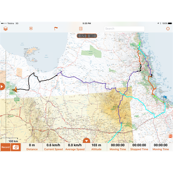
Sample of Hema Explorer daily tracking (colour coded)
AnswerID:
600668