Collinsville - Strathmore - Heidelburg - Burdekin Dam - Towing
Submitted: Sunday, May 29, 2016 at 14:52
ThreadID:
132561
Views:
6273
Replies:
2
FollowUps:
5
This Thread has been Archived
Member - J&A&KK
Planning to drive the above route this week enroute to Charters Towers. Will be towing a
Kimberley offroad van with Prado. Questions are:
Can you drive across the Burdekin river at the dam. On top of the wall?
Also is the road to Burdekin Dam, as outlined, a reasonable road to tow on?
Am in
Bowen at the moment and have asked around but no answers found.
Look forward to your help?
John
Reply By: Member - Mark C (QLD) - Sunday, May 29, 2016 at 17:21
Sunday, May 29, 2016 at 17:21
We traveled that route from Burdekin to
Collinsville in 2010 just after the dam stopped flowing over as the road goes along the base of the dam at the bottom of the spillway. You will need to check if the dam is over the spillway because it would be a long backtrack to find the dam wall
road closed.
Road was okay but we were not towing and has a few
creek and river crossings over causeways.
AnswerID:
600712
Follow Up By: 9900Eagle - Sunday, May 29, 2016 at 19:05
Sunday, May 29, 2016 at 19:05
Just go to this
PAGE and open the river height data with the Burdekin River in it and scroll down to the Burdekin River at the Burdekin dam. This will show the Burdekin is about 600mm below the spillway. The data is up to date.
FollowupID:
870053
Follow Up By: Kevin S - Life Member (QLD) - Sunday, May 29, 2016 at 19:41
Sunday, May 29, 2016 at 19:41
There is a National Parks office at the dam so give them a call. The road From
Bowen to
well beyond
Collinsville is a good sealed road. I think it is sealed most of the way to Mt. Coolon. I can't find Strathmore and Heidelberg on my map but I assume that they are not only suburbs of
Melbourne. The road is sealed from the dam back to the Flinders highway but has cattle wandering over it for much of the journey.
I have hot driven between
Collinsville and the dam but I was involved in heavy transport in that part of Queensland years ago and we used to send some rather large trucks through there quite often. So, like all gravel roads, its condition will depend on when it was last graded.
Give yourself a bit of time to call at
Ravenswood. It has stacks of history and some great
heritage buildings.
Here is a photo of the dam. You can see the road running alolg the bottom of the wall.
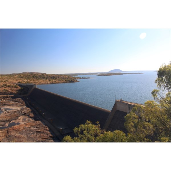
Burdekin Falls Dam
Cheers, Kevin
FollowupID:
870054
Follow Up By: Member - Mark (Tamworth NSW) - Sunday, May 29, 2016 at 20:17
Sunday, May 29, 2016 at 20:17
Kevin
"Strathmore" is a cattle station about 25km west of
Collinsville, though I'm struggling to remember the exact distance from when I worked on it briefly about 35 years ago. It straddled the Burdekin
Mark
FollowupID:
870055
Follow Up By: Kevin S - Life Member (QLD) - Sunday, May 29, 2016 at 20:48
Sunday, May 29, 2016 at 20:48
Tanks Mate. I'll go back to my map and have another look.
Cheers, Kevin
FollowupID:
870057
Reply By: Villatranquilla - Wednesday, Jun 01, 2016 at 14:33
Wednesday, Jun 01, 2016 at 14:33
spoke to the owners of Glendon Station 2 weeks ago and the road on the dam wall is open and expected to remain so. Glendon is about 10 k's south of the Burdekin dam with the river as one of its boundaries. Cattle transports cut the road up this time last year - we did a tyre about 5 k's from the dam and at times used 4WD getting up some of the steeper inclines towing a heavy 23' van on our way to work at Glendon.
AnswerID:
600810