zoom.earth
Submitted: Friday, Jun 23, 2017 at 18:09
ThreadID:
135138
Views:
7978
Replies:
6
FollowUps:
5
This Thread has been Archived
andy
I have been using the web site
satellite map to trace Hanns Track running from the Anne Beadell to the Conny Sue HWY. The satellite maps show stunning cloud formations twice a day. The underlying terrain has a higher resolution than google earth and seems to serve as an unchanging reference. This can be seen when looking at the Wapet Rd where a large truck can be seen at 19deg 54' 53" S / 120deg 44' 27".
Does any one of the readers know more about the provider of zoom earth, where the maps are coming from and at what date they were taken? - Google did not help me.
Andy
Reply By: Ron N - Friday, Jun 23, 2017 at 21:13
Friday, Jun 23, 2017 at 21:13
Andy, does this help you out?
https://neave.com/
Paul Neave utilises NASA satellite and aerial images of the Earth, updated daily.
Cheers, Ron.
AnswerID:
612081
Reply By: andy - Saturday, Jun 24, 2017 at 00:29
Saturday, Jun 24, 2017 at 00:29
Ron, thanks for the hint. I sent an e-mail to Paul Neave
Cheers, Andy
AnswerID:
612096
Reply By: Member - Boobook - Saturday, Jun 24, 2017 at 07:30
Saturday, Jun 24, 2017 at 07:30
Andy, I am not sure of the Provider. I went looking for my vehicle but the daily updates only appeared for when zoomed out.
I use
this site which used Bing for the satellite layer. It generally has more detail than Google Sat.
I have traced lots of tracks, including much of Hanns Track here. You can trace it then upload the track and waypoints as GPX files into Ozi etc. For some reason it works best in Edge for me.
AnswerID:
612098
Follow Up By: andy - Saturday, Jun 24, 2017 at 17:36
Saturday, Jun 24, 2017 at 17:36
Boobook, thanks for the info on Bing. I have compared the images from Bing and View Earth for the Wapet Road. Date and resolution must be the same.
There is a lot information on Bing images including the date of image creation which I will follow up.
http://share.mapbbcode.org/ is indeed very helpful tracing tracks especially if way point files are avaible from Ozi or other sources.
Is there a way to input directly the coodinates of a location in
http://share.mapbbcode.org/?
What does Edge refer to?
FollowupID:
882165
Follow Up By: Michael H9 - Sunday, Jun 25, 2017 at 07:48
Sunday, Jun 25, 2017 at 07:48
Edge is the web browser in windows 10, the next generation of Internet Explorer. I can't believe that Bing is good for anything. I find it to be the worst search engine ever conceived and I'm not alone thinking that.
FollowupID:
882195
Follow Up By: Member - Boobook - Sunday, Jun 25, 2017 at 08:05
Sunday, Jun 25, 2017 at 08:05
Andy..
I don't think there is a direct way to go to a location. However you can create a point in GPX and import that, then it will zoom to that point.
Michael H9. Obviously you have never used Bing Maps for remote mapping compared to Google Maps. Try it. Much better resolution, and generally better tracks.
FollowupID:
882198
Reply By: equinox - Sunday, Jun 25, 2017 at 14:35
Sunday, Jun 25, 2017 at 14:35
That's a terrific site Andy.
Thanks for the heads up.
Cheers
Alan
AnswerID:
612136
Reply By: andy - Sunday, Jun 25, 2017 at 15:56
Sunday, Jun 25, 2017 at 15:56
I found more information on Bing satellite maps as they are used bx Open Sreet Maps. The acquisition dates can be found on
acquisition date of Bing Satellite Maps
The map tile showing the truck on the Wapet Rd was taken between December 2009 and July 2014.
Andy
AnswerID:
612139
Reply By: Mick O - Monday, Jun 26, 2017 at 22:22
Monday, Jun 26, 2017 at 22:22
Mate, why didn't I know about this. It's totally bloody awesome. For someone whose been using google earth for years, it's like being given a pair of quality glasses for the first time. The resolution is incredible. Now if someone can tell me how to covert an image to a jpeg download, I'll be in heaven.
Thanks Andy.
AnswerID:
612179
Follow Up By: Mick O - Wednesday, Jun 28, 2017 at 15:28
Wednesday, Jun 28, 2017 at 15:28
Well I discovered that you can save the image as a .png image file simply by right mouse clicking and selecting the "save picture as" option.
Comparison of resolution quality herewith.

Desert Queen - Google Earth Resolution
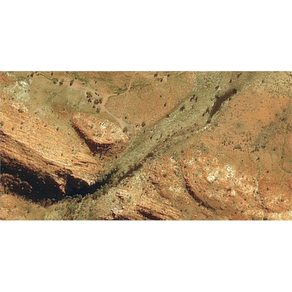
DQB - Zoom Earth
And as per GE, some regions have even better quality.
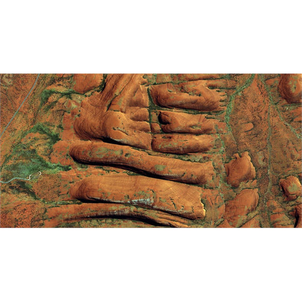
The Olgas - Kata Juta
Overall though, Zoom is light years better than GE. Pity it doesn't have a bit more functionality to make calibration easy.
Cheers
Mick
FollowupID:
882387
Follow Up By: Rainman WA - Wednesday, Jul 05, 2017 at 14:58
Wednesday, Jul 05, 2017 at 14:58
Zoom.earth uses the same imagery that is available via OziexplorerPC with internet maps.
Use the Find Maps button and select the Internet Maps option, then select Virtual Earth Satellite from the drop down list in the control panel.
You can then move between your digital maps and the Virtual Earth imagery and use all the functions built into Oziexplorer.
FollowupID:
882581