Can anyone identify what these facilities are.
Submitted: Friday, Aug 18, 2017 at 13:09
ThreadID:
135420
Views:
5830
Replies:
7
FollowUps:
1
This Thread has been Archived
Gary T7
Location 1 - 28.327421 122.007471
Location 2 - 28.316742 122.843452
While looking at google maps in satelite view I came across these facilities out near
laverton in WA. You need to zoom right in to see. They both look related, same buildings both have bitumin air strips on road in .similar grids on graded areas .may be radio telescopes
location 1 has fence and
gate out to Erliston-Nambi road turn off.
Dose anyone know what they are ? not mines
Reply By: Frank P (NSW) - Friday, Aug 18, 2017 at 13:51
Friday, Aug 18, 2017 at 13:51
I'm guessing they might be part of that new wide aperture radio telescope array
AnswerID:
613158
Reply By: Member - William B (The Shire) - Friday, Aug 18, 2017 at 14:04
Friday, Aug 18, 2017 at 14:04
Now you've done it Gary T7,
That part of Australia will now be a target for the North Koreans.
LOL,
William
AnswerID:
613160
Reply By: 508 - Friday, Aug 18, 2017 at 14:05
Friday, Aug 18, 2017 at 14:05
Location 2 briefly, has
sign saying "Jindalee Radar Transmitter
Site 2, Department of Defence".
Sign is off
Great Central Road.
AnswerID:
613161
Reply By: Member - bill j (VIC) - Friday, Aug 18, 2017 at 14:06
Friday, Aug 18, 2017 at 14:06
Hi Garry T7
Amazing thought id put those coordinates into Google Earth took me to
Taizhou in China ??
AnswerID:
613162
Follow Up By: 508 - Friday, Aug 18, 2017 at 14:15
Friday, Aug 18, 2017 at 14:15
You need to put - before the latitude numbers to designate south of the equator
FollowupID:
883552
Reply By: Steve R17 - Friday, Aug 18, 2017 at 14:26
Friday, Aug 18, 2017 at 14:26
Jindalee Operational Radar Network
There is a
free camping spot just east of the
Laverton site. We had no idea this was here and when darkness fell we could see all the lights in the distance, very eerie.
The Wikipedia article above gives you all the details and location of the other sites for the network.
AnswerID:
613163
Reply By: wombat100 - Friday, Aug 18, 2017 at 16:20
Friday, Aug 18, 2017 at 16:20
Its the "Over the Horizon" radar network
AnswerID:
613171
Reply By: equinox - Friday, Aug 18, 2017 at 19:11
Friday, Aug 18, 2017 at 19:11
Location 2
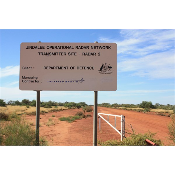
Sign at start of track to Location 2

Location 2 from nearby hill
AnswerID:
613176