Friday, Sep 29, 2017 at 10:32
Hi Al and Rod
Yes David has mentioned that he is working on an updated version of
EOTOPO.
As for a few issues Rod, that is a very far from right answer, there are hundreds.
This reply is in no way aimed at put down David and Michelle,but to try to help them, as to do the updated version, it MUST be done accurately and that is where a major overhaul is urgently needed.
I have sent private emails to David in the past and I will now post my thoughts here, so the so called experts can try to shoot me down...but good luck as I know what I am talking about and have done freelance outback mapping updates for Hema in the past and still offer my
services.
First of all David needs to ( and knowing David personally he would have done it ) overlay his maps with the latest Hema 150k which when used as real time mapping is spot on, no questions asked with the very few exception on minor road changes.
Next David needs to supply regular users of real time mapping a list of areas that he needs field checking. Field checking is critical to the accuracy of any map, weather it is city freeways or outback tracks.
Those that agree to help field check must follow strict criteria and make sure that it is done at a very accurate fashion. This is an area that I am
well aware of, as behind the scenes I have on many times been asked by Hema to field check and record track files for certain areas that we have travelled and to which Hema rewards you
well well...thanks Hema.
Some areas will change slightly over the years and these changes can not be helped. I like countless hundreds of other real time map users originally used the old Natmap series which we know is now
well out of date and the Government would never update it, so it is now down to maps like
EOTOPO and Hema to keep us going in the right direction.
I know it is a very big job to undertake, but if you start it, it needs to be done right and not just rushed out to make it look good. Those that travel using moving maps know just how great a feature it is, but if they are like me, get disappointed to see roads on maps not in the right place or track condition. Here are a few prime example that must be addressed on future updates:
The main road between
Gregory and
Burketown is shown on EPTOPO as dirt, again being bitumen for years.
The Main Road into
Lawn Hill from
Gregory has over 70 kilometres of bitumen,
EOTOPO all dirt.
Many sections of the
Birdsville Track are
well off track and should not be and have not changed for over 10 years when I look back on my personal track files.
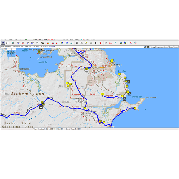
The main road into
Nhulunbuy is so far out.....have a look:
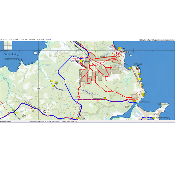
Hema 150K Map...spot on
The Above map is the new Hema 150K maps which is spot on with the blue line my track file overlaid. Here you can see there is no variation of my quality recorded track file to what Hema say is the correct position.
This is the
EOTOPO which shows the
old road from decades ago, showing the Main Road in red and
well east of where the correct position is and shown with my blue line my actual track file that I record while travelling:
The blue line is my recorded track....many kilometres west where EOTOPO shows it
While on the Central Arnhem Highway, there were over $40 million dollars spent between 20012 and 2014 on major road and bridge upgrade and this now does not reflect on any maps as yet, but I know that it will, as the biggest change was the new Goyder River road and bridge, that again takes you many kilometres north of the
old road:
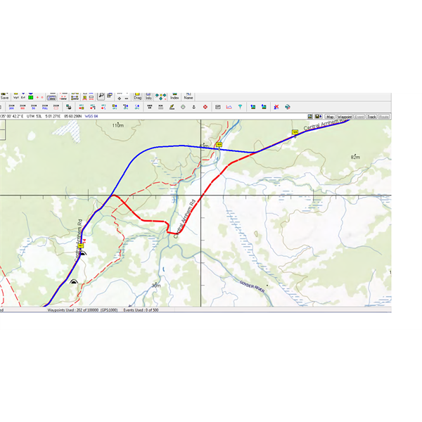
New Goyder River Road...blue is my records track file, well above the red road below
I love the personal touches with
EOTOPO, the colour shading is great, those important little features like
old gravel pit are a wealth of knowledge if looking for a
bush camp, and the extra features that do not show on the Hema 150K map.
As I must say again, we want David to produce a fantastic product that has accuracy and up to date, and not decades behind.
All the best David and please ask for help on track details, and you then can have field checking for you without having to leave the office.
Now waiting for the flack.
Cheers
Stephen
AnswerID:
614042
Follow Up By: Member - Rod N (QLD) - Friday, Sep 29, 2017 at 11:05
Friday, Sep 29, 2017 at 11:05
You are spot on Stephen. I have forwarded David a few of my track files to assist with upgrades.
Is the Traveller App any more accurate? With it now available for Windows 10 computers would this be the way to go.
FollowupID:
884607
Follow Up By: Member - Stephen L (Clare SA) - Friday, Sep 29, 2017 at 14:48
Friday, Sep 29, 2017 at 14:48
Hi Rod
I can not comment on the Traveller App, as I have never used it. Yes it may be available for Windows 10, but if you have no internet.....you are buggered and flying blind I believe, but I could be wrong on this and for this I rely on Oziexplorer and a GPS to record my data.
It may be handy for those in normal so call civilised area or do not want to record accurate track data, where as I travel
well away from phone and internet coverage for often days, sometimes weeks at a time and need reliable information from onboard moving maps.
For that reason, I run 2 laptop computers using Oziexplorer as
well as a Hema Navigator, and even the Hema is set to record data at a 20m rate.
The 2 laptops receive GPS data via a standard Garmin hand held GPS and a GPS mouse. In this way I record my data at a rate that most people would say is crazy. Most people have either Ozi or the GPS set to basic details, which when travelling may record track data at say every 250 to 500 metres or sometimes even greater, which for mapping purposes is totally useless.
For on the run mapping my data is recorded at a rate of ever 20 metres, so you can see data that is collected at a rate of say 250 metres will not have that extra important information that is critical for updating maps. If on foot, I change my record rate on my GPS to every 10 metres.
What the data tells anyone that reads the information is that say every 20 metres it will give you the speed you are travelling, your heading, altitude, the exact GPS coordinates, the distance travelled since the last data was collect, date and time the data is collected and so on.
It is not rocket science, but if members travelling around could take a few minutes to change the way they record their track data and pass this on to David, it will shown him the most important information when overplayed on any of the maps he is working on.
Hope this makes sense Rod, but if those that travel and record Data and get it to David, this is the information that makes accurate maps.
Cheers
Stephen
FollowupID:
884616