EOTopo 2018 Beta
Submitted: Monday, Dec 11, 2017 at 20:01
ThreadID:
135969
Views:
5333
Replies:
6
FollowUps:
8
This Thread has been Archived
ExplorOz - David & Michelle
Hi Folks,
I have just about finished the first pass of development for
EOTopo 2018 and have a beta version running in the online systems. You can see it in the
EOTopo Online page or also the
Places & Treks pages. In
Places I have also added an option to allow you to see the 2015.1 vs 2018Beta (look at the upper RHS layer control). Oh and make sure you use the full screen control (under the zoom controls) to fill your whole screen with the map.
The
EOTopo 2018 is a major update and consolidates our excellent recently updated outback road network with an excellent roads and streets network. There is also a number of new and updated base data layers including:- railways, parks, beaches, parks,
water bodies and we have customised a number of perimeter networks like built up areas and amenity areas (like schools & universities). In fact there are so many changes I cannot remember them all, I have been working on this for over 12 months!
In the 2018Beta online beta we now have zoom levels to 18K (zoom level 16) and we have the ability to go further however at this stage have set a limit to 16.
We are still working on the fonts and some text styling but for the most part the project is ready for you to view. I have added a current zoom number in the online map system (there is a box under the zoom controls with a number - that is the current map zoom). Also in this box is an indicator showing that the loading is busy - On this point please BE PATIENT the system is drawing a caching the tiles upon first open - there are over 20 million tiles to draw and the data processing is a little intense - so please wait for the indicator to show that the load is finished (I have upgraded the web and database servers for this beta, but it still is taking time). Once it has been drawn once it will be cached and render quickly next time round (for the next users or your next visit).
The production release of
EOTopo 200K raster mapset is a map in the middle of zoom 12 & 13. We are working to possibly build the 200K raster map product at 144K for the 2018 release but need to look at the file sizes before we can be sure. It takes a few days to render, slice and setup the map and we need to be sure it is right before we undertake this task. So have a look online and provide us any feedback or thoughts you may have - as most of you will understand we take in all feedback and use it to produce the best results for all.
David
Reply By: ExplorOz - David & Michelle - Tuesday, Dec 12, 2017 at 11:50
Tuesday, Dec 12, 2017 at 11:50
Something I forgot to mention is that zoom level 13 is the 144K level for those that are interested - I have ensured that street level roads are visible but to have any chance of visibility the lines are very small.
AnswerID:
615479
Reply By: Member - wicket - Tuesday, Dec 12, 2017 at 12:00
Tuesday, Dec 12, 2017 at 12:00
So you are using OSM maps as your base now, were you using these in previous versions ?
Is there any way to distinguish tracks on private property , farms etc from public tracks, i ask because previously there was no way to distinguish and it did become a bit confusing.
AnswerID:
615480
Follow Up By: ExplorOz - David & Michelle - Tuesday, Dec 12, 2017 at 12:28
Tuesday, Dec 12, 2017 at 12:28
We are using OSM for the residential street road network (we have been using this as the Streets & Paths on existing mapping interfaces) and are using our own updated ported versions of previous
EOTopo roads data (which is a mix of GeoScience and ExplorOz User Treks and Treks data) for the rural data network. The road data conflation process was the hardest part of this release as OSM and all road map data providers have little or no rural data that is reliable so our process was to bring these together - it took me the best part of 18 months to conceive and convert the networks. Hopefully we have the best of both worlds but we have full access to all the data so can update and change independently of OSM on any level - plus we have an in-place upgrade mechanism that means we can easily update the road network each year to facilitate updates to the streets data. However 2018 uses data from all over the place to produce a best of breed topology - for instance last week I spent 2 days converting a data set from the ABS which is called the 2016 Mesh Boundaries and this produced our built up areas system which was used to not only identify built up residential roads (to make them appear smaller at larger scales) but forms an opacity based
grey overlay on the map to identify what is effectively a built up area. This sort of data has been added to all layers and levels so it is not at all correct to say OSM is the base map because it is not it forms part of the overall combination of data sources.
No there is no way to distinguish private property from open roads as this would not be topographic, nor would it be possible to maintain. We have identified a number of roads on the map that are private but it is not possible for any map provider to maintain this. We can mark them if we are advised but the other problem them becomes who tells us if the status changes. We have identified all areas of Native Title as a data layer again from the ABS but this does not provide any level of permit requirement or access controls. The other element is that in an emergency situation it does not really matter if it is private or not - if it is there is should be on the map - but as mentioned if we know we can mark it. If a land owner has a
sign or
gate that is your best guide - failing that it is not really possible to fully identify but just because it is on a map does not mean you can use it freely.
David
FollowupID:
886466
Reply By: ExplorOz - David & Michelle - Tuesday, Dec 12, 2017 at 14:56
Tuesday, Dec 12, 2017 at 14:56
I have also just added the 2018Beta maps as the default in the User Treks system so for anyone with data in that system you can align your
routes with the latest mapping system to ensure/check the accuracy of the database.
David
AnswerID:
615482
Reply By: Member - Racey - Tuesday, Dec 12, 2017 at 15:24
Tuesday, Dec 12, 2017 at 15:24
Hi David & Michelle, just opened the new online map on my Android mobile via Chrome. Looking good so far and I like the zoom feature. Looking forward to seeing it on my regular pc.
One thing must mention is the current calibration. We are currently caravanning at
Towong Reserve which is just over the NSW boarder approx 2.5 klm from the township. The
camp spot is marked on the map.
I noticed the my position was approx 2 klm on the edge of the Towong township. Is this a calibration issue or something to do with my Sony Xperia phone. Positioning works fine with Google Maps.
Looking forward to the release.
Cheers
Jon
AnswerID:
615483
Follow Up By: ExplorOz - David & Michelle - Wednesday, Dec 13, 2017 at 01:09
Wednesday, Dec 13, 2017 at 01:09
Jon,
Not 100% sure however the web browser positioning function does not generally get a position from the gps more often it uses cell tower triangulation or ip lookup for web based map queries. An app that interfaces directly to the gps will be giving the right position and trust me there is no calibration issue of that magnitude within the map data.
David
FollowupID:
886482
Reply By: Member - Stephen L (Clare SA) - Tuesday, Dec 12, 2017 at 19:21
Tuesday, Dec 12, 2017 at 19:21
Hi David
Can you please look at my user tracks.....
I have only looked at 2 of my recent treks so far and the road to
Nhulunbuy is still wrong. As I have said my trek shows a number of new roads that now bypass a number of major crossings, including the new
Goyder River crossing that was completed in 2014.
I hve made sure that it was the 2018 beta version, so it still needs some tweaking to make it accurate.
A quick look at other roads in the
Nhulunbuy area are also wrong and no longer exist.
Cheers
Stephen
AnswerID:
615484
Follow Up By: ExplorOz - David & Michelle - Wednesday, Dec 13, 2017 at 01:04
Wednesday, Dec 13, 2017 at 01:04
Ah not sure Stephen I just double checked your user trek and the whole area and every road is there in exactly the place represented in your user route file. Including the crossing and all roads you travelled. I may be additionally showing the
old road as i believe it is still there just not being used, but if not I can simply remove it however the right roads are there 100% as represented in your user trek. You may need to look away from the user trek page as the purple line may be covering the roads. From the user trek index (only) you can turn on/off the user trek overlay to confirm.
FollowupID:
886481
Follow Up By: ExplorOz - David & Michelle - Wednesday, Dec 13, 2017 at 01:23
Wednesday, Dec 13, 2017 at 01:23
I just checked that exact crossing and there appears to be a mismatch between my workstation and the online map. I will need to investigate but off for a few days break will get back to you next week. Was there a specific other example you can point me at. I am confused why that road appears different but may have not republished one part of the database. This is what the beta concept was for so thanks for the alert.
FollowupID:
886483
Follow Up By: Member - Stephen L (Clare SA) - Wednesday, Dec 13, 2017 at 07:27
Wednesday, Dec 13, 2017 at 07:27
Hi David
Enjoy your time off and make sure you leave your phone home.....lol
I did send you a couple more examples of wrong roads in the area via private email. With the new roads in the
Nhulunbuy area and the main Central Arnhem Highway that we travelled are the main roads. All new detours no longer give access to the old original road and in most cases, large wind rows and trees have been dragged over the old roads so people can not use them and to let's them revegetate and in a few years will be back to natural bush.
Cheers
Stephen
FollowupID:
886486
Follow Up By: ExplorOz - David & Michelle - Tuesday, Dec 19, 2017 at 12:00
Tuesday, Dec 19, 2017 at 12:00
Thanks Stephen,
Funny I missed this followup as it would have helped me in the questions I just emailed you about the older roads around the newer crossings. Would you be so kind to just confirm via the email I just sent as it has all the updated screen shots for the roads in question. Thanks again for your feedback I am fairly convinced this area is much more accurate however I just need to work out what roads to remove now.
David
FollowupID:
886666
Follow Up By: Member - Stephen L (Clare SA) - Tuesday, Dec 19, 2017 at 13:05
Tuesday, Dec 19, 2017 at 13:05
Hi David
I have replied and included a couple of photos of the new roads and bridge crossings.
If they do not come through, please let me know.
Cheers
Stephen
FollowupID:
886668
Reply By: Member - J&A&KK - Thursday, Dec 14, 2017 at 11:00
Thursday, Dec 14, 2017 at 11:00
Hi David and Michelle
The work required for this upgrade would have been significant. Not an easy task integrating the data sets involved. I am sure all of using
EOTopo will benefit from your work in one way or another. Publishing a Beta version should give you some decent feedback if sufficient members become involved in the testing process. Not many comments to date which must be a bit disappointing.
I have had a look at road features around the
Marble Bar area and compared them to my own data collected in May of this year. No issues with locational data but one with road classification.
Firstly I cannot find the map legend so that makes it a bit difficult.
The
Marble Bar Hillside Road is represented by two different continuous red lines from MB to Tambina
Creek suggesting differing road categories. This is not the case.
In addition there appears to be a bug in the rendering of the layers. At zoom level 11 the Hillside road is not shown at all, when other tracks near it are shown. At zoom level 12 the road is shown.
Regards John
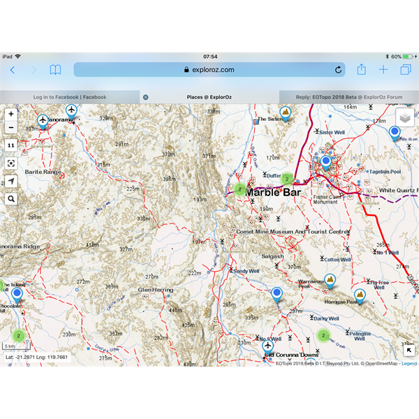
Zoom Level 11
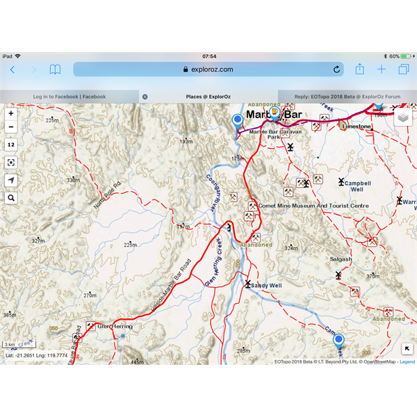
Zoom Level 12
AnswerID:
615519
Follow Up By: ExplorOz - David & Michelle - Tuesday, Dec 19, 2017 at 11:58
Tuesday, Dec 19, 2017 at 11:58
Thanks John - I will have to work out why that road is different - we are turning stuff on/off at differing levels however it would appear that there is something funny with that road as it should be enabled on zoom 11 - I will check this out as it will be effecting all areas with this road type (which could be many). It is difficult as the roads network is build from 4 different databases all with differing fields and field codes so in one db the highway = track and in another the class = Track, all good fun (not) and many hours of pouring over data definitions.
David
FollowupID:
886665