Kata Tjuta to near Puta Puta (on Gunbarrel) track - info?
Submitted: Monday, Feb 19, 2018 at 13:30
ThreadID:
136291
Views:
5953
Replies:
5
FollowUps:
7
This Thread has been Archived
Member - techedge
I couldn't find a name for this 194km track starting near
Kata Tjuta (the Olgas) and going west south west until it reaches the Gunbarrel west of
Puta Puta.
It it possible to travel this route (including by bicycle) yes, I know it's remote, and probably not
well used, and probably requires permits, etc.. (but thanks for being concerned)
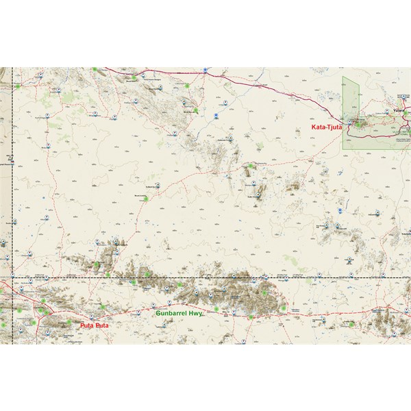
Track from Kata Tjuta - near Pita Pita
Reply By: Member - McLaren3030 - Monday, Feb 19, 2018 at 13:43
Monday, Feb 19, 2018 at 13:43
Techedge, In my Hema Atlas, it is just listed as Private Road, and doesn't go all the way to
Kata Tjuta. My guess would be that it is access into Aboriginal Land, and you may not be able to get a permit. There is also another Private Road that runs from just west of Kalka on the Gunbarrel north to Docker River, I suspect the same would apply for access to this road as
well.
Macca.
AnswerID:
617045
Follow Up By: Member - techedge - Monday, Feb 19, 2018 at 13:47
Monday, Feb 19, 2018 at 13:47
I'm hoping someone can tell me they did, or didn't, travel it - it's always good to know about alternate tracks, even if the plan isn't actually to use them. Thanks Macca.
FollowupID:
888498
Follow Up By: Member - McLaren3030 - Monday, Feb 19, 2018 at 13:58
Monday, Feb 19, 2018 at 13:58
We actually drove another road from the
Gunbarrel Highway just west of the W.A. S.A. border through to the
Great Central Road, comes out approx. 26 kms east of Giles.
Macca.
FollowupID:
888501
Reply By: RobAck - Monday, Feb 19, 2018 at 16:07
Monday, Feb 19, 2018 at 16:07
That's a private track on APY land so I would not expect a yes but no harm in asking. Check with the Central Land Council in
Alice Springs and expect a referral to the APY Board
That area is extraordinarily remote and having had a look at parts of it around 10 years back very overgrown but the recent fires may have fixed that. No
water, lots of dunes and nobody for
miles in any direction.
Still quite beautiful in its own way
Rob
AnswerID:
617047
Follow Up By: Member - techedge - Monday, Feb 19, 2018 at 16:39
Monday, Feb 19, 2018 at 16:39
Rob, I really appreciate your reply. Thanks!
You can see how unique the area is!
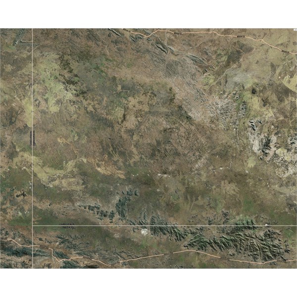
APY Lands
FollowupID:
888506
Reply By: Allan B (Sunshine Coast) - Monday, Feb 19, 2018 at 16:36
Monday, Feb 19, 2018 at 16:36
.
On my map that track is marked as "Mantanur", presumably "Mantanur Track".
It passes through what I assume are settlements Mantapayika, Umutju and Walytjatjata before joining the Gunbarrel
Hay about 10km west of
Puta Puta.
I know nothing about it, or permits, and do not know if the marked settlements are inhabited.
AnswerID:
617048
Follow Up By: Allan B (Sunshine Coast) - Monday, Feb 19, 2018 at 16:41
Monday, Feb 19, 2018 at 16:41
.
Further searching tells me that Mantapayika is (or was) a station and Walytjatjata is a culturally significant aboriginal place, not occupied.
FollowupID:
888507
Follow Up By: Member - techedge - Monday, Feb 19, 2018 at 16:42
Monday, Feb 19, 2018 at 16:42
Allan, Just the northern few km from
Kata Tjuta are marked as Mantanur, otherwise it's mostly unnamed for most of its almost 200km - at least on all the maps I've seen so far.
https://en.wikipedia.org/wiki/Walytjatjata
FollowupID:
888508
Reply By: Mick O - Monday, Feb 19, 2018 at 22:42
Monday, Feb 19, 2018 at 22:42
The Giles - Mulga
Park Road (also referred to as the Old Gunbarrell Hwy) in my humble opinion is one of the finest and most picturesque drives in Outback Australia. The Mann and Musgrave Ranges in particular are spectacular (Mt Woodroffe, SA’s highest peak sits in the Musgraves also).
The southern end of the track you are seeking info on lies within SA’s APY lands and as such a permit will be near impossible. The track is simply that, a track. It is irregularly maintained and rarely used. The northern end sits in the Uluru-Kata Juta National
Park so again almost a zero chance of getting a permit. Both ends of the track still get use but the middle, less so. It’s used as a thoroughfare by the locals but there are better business roads are available for that purpose.
You may have some luck getting a permit for the Giles Mulga
Park Road but would need to exit after Wingellina on the Mt Davies Road which takes you up to the
Great Central Road just east of
Warakurna Roadhouse. If you are caught on the GMPR without a permit, there are numerous abatements that can be applied not the least of which is being escorted back to the main road. The APY lands are one of the few areas under Native Title individually protected by a specific act of parliament.
It’s a shame as it’s magnificent country that could provide a real tourism boost for many APY communities.
Permits applied for through APY (office in
Alice Springs). Form available on line. Anything above the border in NT, Central Lands Council in
Alice Springs. West of the
SA/WA border, WA Dept Aboriginal Affairs permit application through DAA website. Apply months in advance as it could take some time unless you are going for a specific purpose (helping out at a community etc).
Cheers
Mick
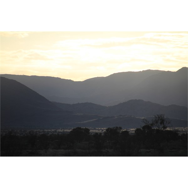
Mann Ranges at Dawn
AnswerID:
617052
Follow Up By: KevinE - Tuesday, Feb 20, 2018 at 10:59
Tuesday, Feb 20, 2018 at 10:59
While it won't help the OP on his current trip planning, there may be a ray of hope coming re accessing the APY lands Mick.
I had a very informative chat with a drive in/drive out govt employee who visits the lands regularly; he said that the locals do realise the value of tourism & are actively pursuing a limited opening up of the area to tourists. Apparently, it's
Adelaide based bureaucracy that's not keen on the idea. The same govt employees who are about to shut down
Mintabie.
Hopefully the traditional owners will win the battle!
FollowupID:
888526
Follow Up By: Mick O - Tuesday, Feb 20, 2018 at 22:47
Tuesday, Feb 20, 2018 at 22:47
Thanks Kev. There's hope yet and again not much help to the OP and also not wanting to open the floodgates for ill informed comment. Thank god the
Adelaide based whiteys know what's best for the communities and the aboriginal people! (Hope that wasn't dripping with too much sarcasm!)
Hopefully common sense will prevail and some self determination might see a positive result for all concerned.
There is real potential there but it needs to be community based and developed and driven by the local people. Many Australians, myself included, would not mind paying for the privilege of visiting and being guided through this amazing country. All the better if the initiative was providing real opportunities for indigenous communities and indigenous youth in particular.
Keeping my fingers crossed.
Mick.
FollowupID:
888542
Reply By: Member - Bigfish - Friday, Feb 23, 2018 at 19:07
Friday, Feb 23, 2018 at 19:07
I,ve driven the track a few times when I was a remote area tech for Telstra. We had a special permit for all roads in W.A. , N.T. and Qld. Great drive and yes it is not open to the public. I dont know how you would go about getting a permit though.If you do not get a permit do not attempt to pedal/drive it. Penalties can be severe. It is isolated with lots of camels and sandy roads. Some very sharp corners as
well (I know of a Telstra chap who came unstuck! Luckily satphones are carried and essential. I drove some other roads in the area that are off limits as
well. Those days are gone now but still a highlight of my life.
Cheers
AnswerID:
617142