Old Karungie Road / King River Road
Submitted: Monday, Feb 19, 2018 at 20:44
ThreadID:
136292
Views:
4466
Replies:
4
FollowUps:
10
This Thread has been Archived
Craig M1
Hi Team
I am planning to do the GRR this July and from our base in Home Valley or Elquesto was wanting to include a day drive around the
Cockburn Ranges.
I have read some previous entries on this
forum but they were back in 2010 and may be the drive has changed since then.
We will be in Landcruiser 200 series and some queries I have are:
1) I understand the
King River track from the Pentecost Crossing to Diggers Rest ( ie on the western side of the
Cockburn Range) and then on to the GNH near
Wyndham is a Public Access and as such no permit is required. Is this correct?
2) Do I need a permit for the track from Diggers Rest south to the GRR. That is the track on the eastern side of the
Cockburn Range. (One of my Hema maps shows that it is a private track ). Can I get permission to use this track and if so who from? What is the normal condition of this track?
3) are there any access tracks up on to the
Cockburn Ranges that provide good vistas. Do I need permits to use them?
4) is this circuit doable in a day without rushing it.
Cheers Craig
Reply By: Peter_n_Margaret - Monday, Feb 19, 2018 at 21:01
Monday, Feb 19, 2018 at 21:01
I may be WAAAAAAAY out of date now, but I reckon both of those roads are on ElQuestro property. They tried to close the Pentercost to Diggers Rest one some years ago, but failed because it is a public road. The eastern one is not a public road, so they can and have closed it.
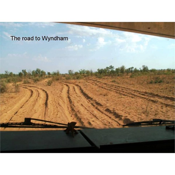
Between the Pentercost & Diggers Rest, 2005.
Cheers,
Peter
OKA196 motorhome
AnswerID:
617050
Follow Up By: Craig M1 - Monday, Feb 19, 2018 at 21:24
Monday, Feb 19, 2018 at 21:24
Thanks Peter.
FollowupID:
888523
Reply By: Member - Phil 'n Jill (WA) - Monday, Feb 19, 2018 at 23:03
Monday, Feb 19, 2018 at 23:03
Hi Craig - The country around the
Cockburn Range is definitely worth visiting.
The Karungie Track from Pentecost into
Wyndham past Diggers Rest is part of
El Questro from memory, but you can check access availability from
the Diggers Rest Station through their website details:
Roderick and Alida Woodland
Diggers Rest Station
PO Box 5
Wyndham WA 6740
Phone: (08) 9161 1029
International: +61 8 9161 1029
Mobile: Roderick 0419 941 236 Alida 0418780337Def
They provide excellent treks around that area - the old fashioned way - on horseback for anyone who is interested.
Cheers - Phil
AnswerID:
617053
Follow Up By: Craig M1 - Tuesday, Feb 20, 2018 at 01:10
Tuesday, Feb 20, 2018 at 01:10
Thanks Phil I will follow up Diggers Rest.
FollowupID:
888524
Reply By: PhilD - Monday, Feb 19, 2018 at 23:43
Monday, Feb 19, 2018 at 23:43
Drove it in 2016.
Wyndham turnoff to Diggers Rest is public road, and then onto
El Questro. There is a top and bottom track.....the bottom across the flats, and the top through the ranges when the bottom is not passable. Top is slower and a lot more rock to traverse.
Doable in a day if reasonable conditions. We stayed at Diggers Rest for a night. Small
camp ground with hot showers.
AnswerID:
617054
Follow Up By: Craig M1 - Tuesday, Feb 20, 2018 at 01:12
Tuesday, Feb 20, 2018 at 01:12
Thanks Phil.
FollowupID:
888525
Reply By: Life Member - Duncan W (WA) - Tuesday, Feb 20, 2018 at 11:05
Tuesday, Feb 20, 2018 at 11:05
Hi Phil, did it also in 2016. Coming from
Wyndham end you can take a short cut across the mud flats to cut off a chunk of the corrugated road. The road for quite some distance follows the
King River.There is an
aboriginal art site on the track to
Moochalabra Dam which is worth a look at. Next up is the Boab Prison Tree which is a seriously ancient tree.
We found the
gate, just south of the prison tree, locked to the track that follows the
King River down to the GRR. Not far past the turn off to Diggers Rest the track terminates at a
gate that isn't locked and there is a
sign that warns you about the Karunji Track and to travel it with care.
A pretty easy track to start with and would have been a doodle if we had stayed on the lower mudflats track but some how or another we missed a turn to the right and ended up on the upper range track. This track was fun with a number of interesting eroded sections and the odd section of rock and sand.
The track finally terminates at the
Pentecost River fording on the GRR. This final section was the sandiest and softest section.
We started the track (passing through the
gate) at 3:00pm so really late ion the day which didn't really allow us to smell the roses so to speak. We finally got to the GRR just after sunset, so being July about 5:30pm or so. Getting back to
Kununurra at 7:00pm.
Fantastic drive and I wished we'd done it again last year but time didn't permit.
Enjoy the drive and take plenty of photos as there will be many an opportunity to do so.
Cheers
Dunc
AnswerID:
617057
Follow Up By: Dean K3 - Tuesday, Feb 20, 2018 at 12:33
Tuesday, Feb 20, 2018 at 12:33
Love to know where that short cut is.
I have taken the road past the
wyndham water supply prision boab tree and then turned around back towards
wyndham as a day trip.
Unless I knew exactly where to re join reckon I be rather bogged up
creek without a paddle somewhere
FollowupID:
888527
Follow Up By: Life Member - Duncan W (WA) - Tuesday, Feb 20, 2018 at 12:39
Tuesday, Feb 20, 2018 at 12:39
Dean only reason I know about it is that while we were driving around the mudflat on the normal road, we spotted a Council truck driving right across the flats. This may only be a seasonal thing and a bit of local knowledge as like you we didn't see anything to suggest a track across.
FollowupID:
888528
Follow Up By: Craig M1 - Tuesday, Feb 20, 2018 at 13:08
Tuesday, Feb 20, 2018 at 13:08
Thanks Dunc
Great information.
Cheers Craig
FollowupID:
888529
Follow Up By: Peter_n_Margaret - Tuesday, Feb 20, 2018 at 13:57
Tuesday, Feb 20, 2018 at 13:57
We drove across the flats in 2005.
You go along the airfield
boundary near
Derby. There were other flats as
well as a low causeway and stony ground prior to this (driving north).
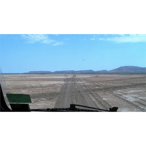
Derby straight ahead
Cheers,
Peter
FollowupID:
888531
Follow Up By: Dean K3 - Tuesday, Feb 20, 2018 at 17:39
Tuesday, Feb 20, 2018 at 17:39
@ Dunc yes its very much a seasonal & local knowledge thing even the WAPOl coppers do it as a short cut to get across to maybe Kalumbaru without going all way down GRR via ELQ etc. Also seen it on TV kimberly cops or similar not that I make habit of watchign such staged shows
With trip I did 2014 as mentioned above, even with a dry wet was still plenty of soft sections as I drove along the official road/track.
@ Peter sure thats not
Wyndham your thinkign of that snap shot looks very much like there not
Derby unless its the mudflats near parrys
lagoon bird sanctuary
FollowupID:
888534
Follow Up By: Peter_n_Margaret - Tuesday, Feb 20, 2018 at 17:51
Tuesday, Feb 20, 2018 at 17:51
Duuuuur, Yes,
Wyndham. Thanks Dean...
The other track nearby that is worth a drive is the one that goes west from
Wyndham then north past the old slaughter house and then around the Bastian Range.
Cheers,
Peter
OKA196 motorhome
FollowupID:
888535
Follow Up By: Life Member - Duncan W (WA) - Tuesday, Feb 20, 2018 at 18:15
Tuesday, Feb 20, 2018 at 18:15
Peter I saw a car heading out that way when we were leaving the Parry
Lagoon Rd and wondered where it went - now I know.
FollowupID:
888536