Blog Review: The 2014 Expeditions - In the footsteps of the Greats! 'Glen Edith'
Submitted: Saturday, Oct 19, 2019 at 17:43
ThreadID:
139211
Views:
4835
Replies:
1
FollowUps:
0
This Thread has been Archived
Linda R7
My Blog Rating: 
This is fantastic!
I have been reading Australia Twice Traversed for the second time. I am trying to map it out as I read it this time because I would like to follow as much of Ernest Giles'
trails as possibleover the next few years. Reading about Glen Edith I thought I really really would love to visit this location but was struggling to pinpoint it. That is how I discovered your blog.
I have a few questions.
1. Do you have any maps from the Ernest Giles trips?
2. Is it very hard to get permission to visit these locations and is it difficult to access with 4wd?
3. Did you see any of the marked trees mentioned in the journal?
4. From the picture attached can you tell me if I am anywhere near guessing the correct location of Glen Edith?
Thank you
Linda
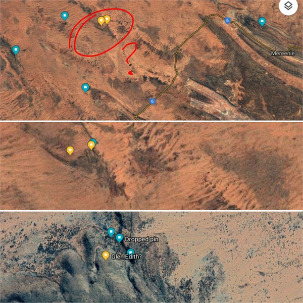
Location of Glen Edith?
Reply By: Mick O - Monday, Oct 21, 2019 at 21:44
Monday, Oct 21, 2019 at 21:44
You are 1.5 km too far north. The Tarn is an unassuming crevice while Glen Edith a broad grassy bowl. Both are nothing special and it was Giles romantic style of writing that painted a portraiture far more grand than it actually is.
It was sheer luck that he found it although he passed within a few kilometres of two of the most significant waterholes in the region, Thomas Reservoir and Muranji Rockhole.
I was fortunate enough to go to this site with Dick Kimber,
well known historian and a man revered by all skin groups between Alice and the WA Border. Sadly it is extremely difficult to get permissions to visit here.
Contact me on mickolsen13@gmail if you'd like to discuss further.
Regards
Mick
AnswerID:
628254