Jackson Ularring Road

Submitted: Monday, Dec 09, 2019 at 21:06
ThreadID: 139407 Views:12773 Replies:7 FollowUps:7
This Thread has been Archived
Hi there folks,

I was at Ularring with my father last weekend.

The main soak had water, the little known secondary soak had none.

The well south of the rock was quite deep. It had water at the bottom – Amazing that is still serves its purpose after over 100 years.

I will try to retrace the old Jackson to Ularring Road, a main road gazetted in 1900. (though I will start at Ularring)

Due west of Ularring was a track and I started to follow it. Now I must say that this may not be the actual original track however this was my first reconnaissance of the historical track so I am not being to fastidious with the exact line.

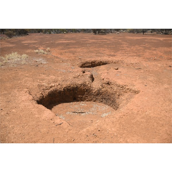
First stop was Maningu Soak. This is marked on most maps as a waterhole however not named. It took a while to find but spotted it away from the adjacent outcrop. It was dry – not surprising however over the years it would need maintenance.


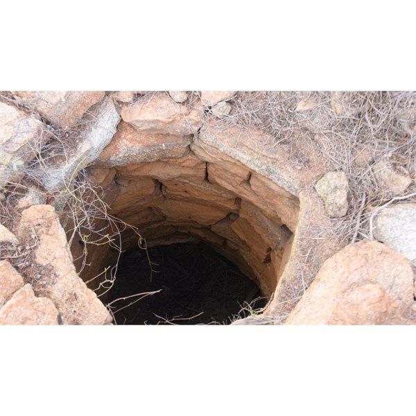
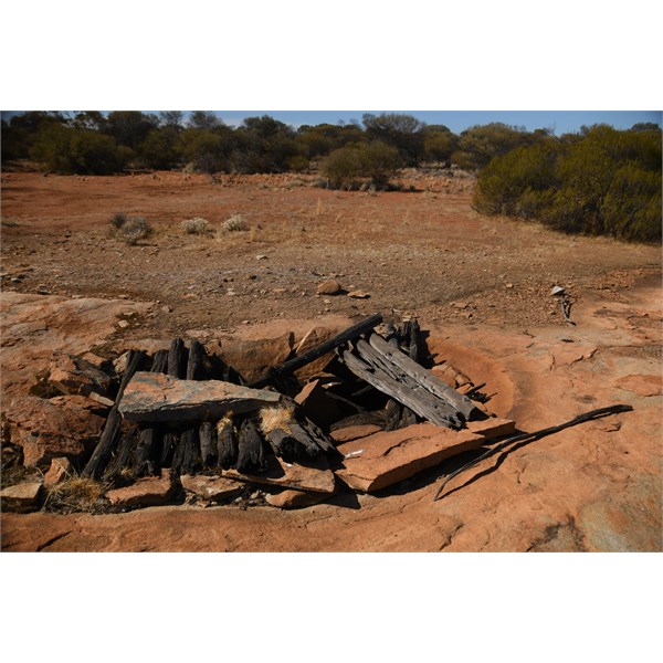
Passing Yowie Rock we came to 
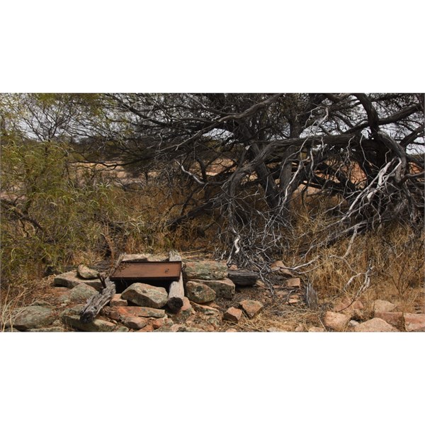
Gedagie Soak, we found it in a state of decomposition – I thought how much this well would have be relied on back in the day.


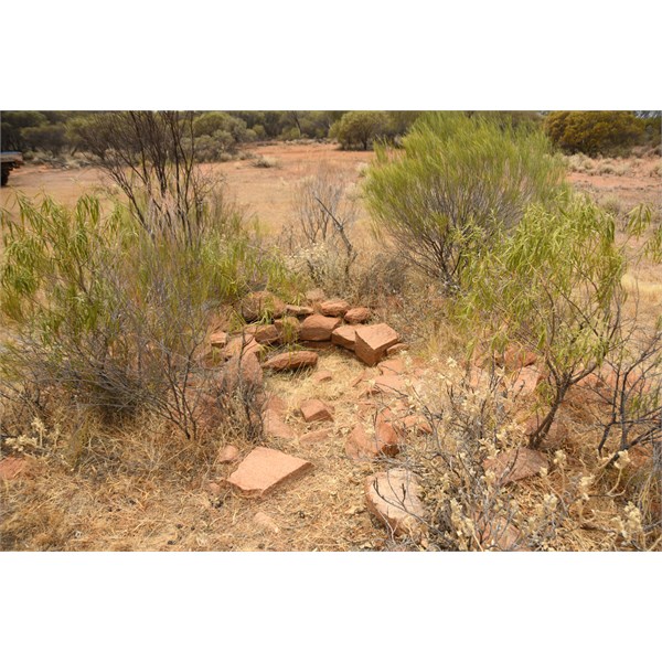
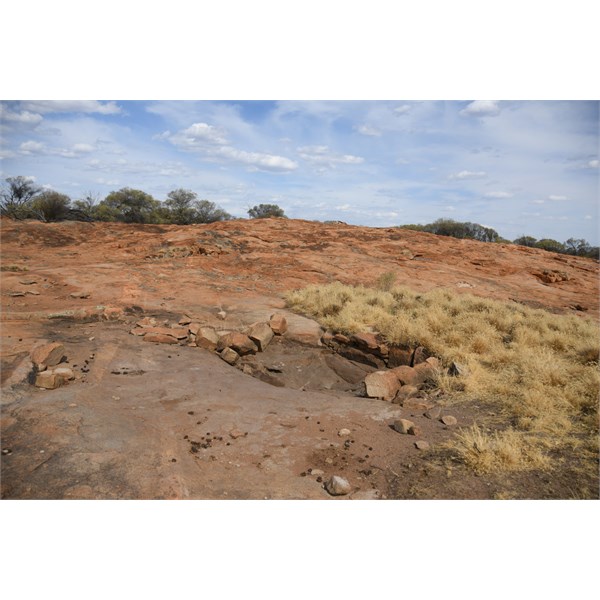
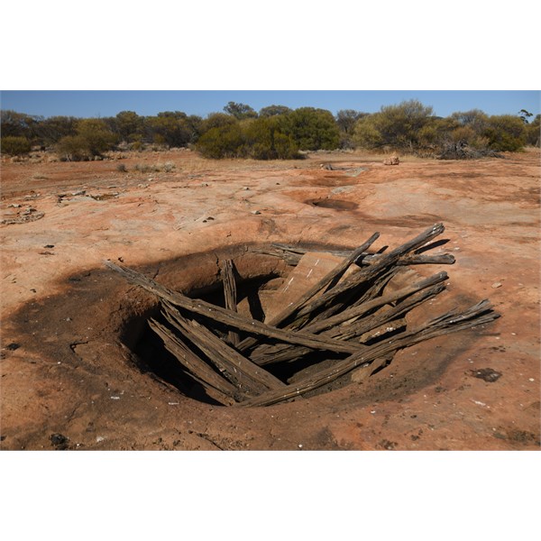
Coorara Soak was next on the track – I was surprised the original wood had not been removed or burnt. This was dry.


Yerilgee made itself known sooner than expected. A gnamma, and either a gnamma or a main made gnamma altered to fit a 1000 gallon tank.


Here the old track veered north west to Wogling, however the track we were on went to the south west to Kurrajong Rockhole, then an option to the north west to Wogling. We thought we could make out a faint track to the north west but decided to go to Kurrajong, as it would probably be quicker that going off track for 20 kms and the associated potential tyre repairs.

Kurrajong (or Currajong) is a nice large gnamma – it was dry – there were old timer inscriptions on the faces around the rockhole.
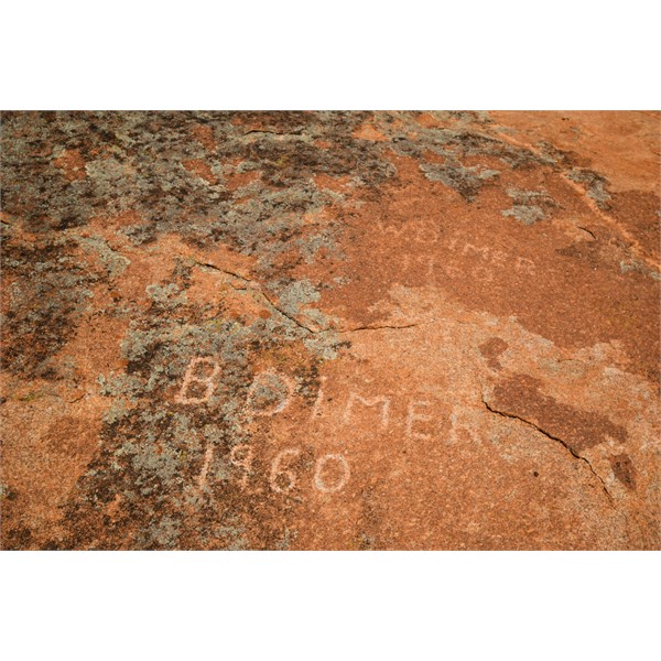


We arrived at the outcrop I presumed was Wogling, and we saw immediately a rockhole only 6 metres from the track.


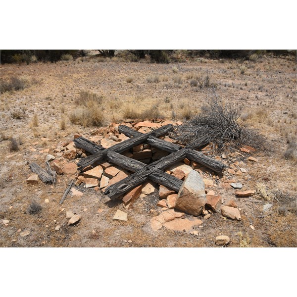
Onto Dooling Soak. I only relied on a hunch as to were this may be. It was off the main track about 400 metres and was horrendously thick scrub. There was an old track but it was useless. I found a well which surely had not been looked at for many a year. I assume this is Dooling Soak however will stand corrected without prejudice if found incorrect.
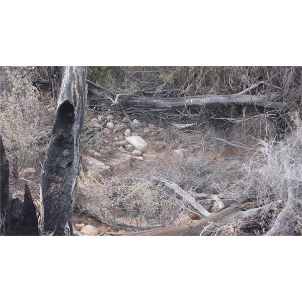


From here I need to head to the south west if I was to continue along the old track. However, the bush was very thick thought it best to go back along the main track (to the south of Mount Manning Range).

I dearly wanted to find a track to the south. The are two main wells, Chatarie and Stinking Wells – Chatarie was not technically on the old track however was not far off it and was a substantial watering point.

Whilst on the main track heading west I thought I’d check Olby Rock. There is quite a few gnammas there – two of which have the original (or at least very old) wooden and stone covers, sunken low due to their age.


All the way round to the west and then south (via Die Hardy Range) I looked for a way in Chatarie to no avail. Very thick bush and no tracks.

I think these wells will need a quad bike to search in the future some time.

Marda still had plenty of water and the Jackson Freemasons Lodge still remains a testament to times past.

As I say this was my first recon of the track so it will probably be altered or fine tuned in the future.

Oh yes I saw my first Tawny Frogmouth in the wild too!!!

Cheers
Alan

Looking for adventure.
In whatever comes our way.


Lifetime Member
My Profile  My Blog  My Position  Send Message

Back Expand Un-Read 19 Moderator

Reply By: Member - Stephen L (Clare SA) - Monday, Dec 09, 2019 at 21:52

Monday, Dec 09, 2019 at 21:52
Great read Alan, well done

Season Greetings

Stephen
Smile like a Crocodile

Lifetime Member
My Profile  My Blog  My Position  Send Message

AnswerID: 629043

Reply By: Rod W6 - Monday, Dec 09, 2019 at 22:54

Monday, Dec 09, 2019 at 22:54
G'day Alan,

At Dooling Soak was there a steel framed chair there?

The Dimer family left their mark all round the place like Johnston Rocks and further south at Reids stone hut.

I have copy number 501 of 1000 copies of Karl Dimer's book "Elsewhere Fine" of his life growing up on Nanambinia Station set up by his father who jumped ship (an American whaling ship) around 1884 in Albany. I've been reading the book for the last 15 or so years (only get to read it when I go bush), have about 70 pages to go. I'll finish it one day.
AnswerID: 629046

Follow Up By: equinox - Tuesday, Dec 10, 2019 at 19:59

Tuesday, Dec 10, 2019 at 19:59
Hi Rod,

I did not see a steel framed chair at Dooling. Maybe it was covered with vegetation?
The adjacent outcrop was quite small compared to most.

I have seen the Dimer mark before on the lid of the tank at Darrine and on the rockface at Coomine.

Cheers
Alan

Looking for adventure.
In whatever comes our way.


Lifetime Member
My Profile  My Blog  My Position  Send Message

0
FollowupID: 903754

Follow Up By: equinox - Friday, Dec 27, 2019 at 20:58

Friday, Dec 27, 2019 at 20:58
Hi again Rod,

I have created a stitched drone picture of the outcrop.


Link to zoomable picture

I didn't spot a chair however pays to have a second opinion :-)

Cheers
Alan


Looking for adventure.
In whatever comes our way.


Lifetime Member
My Profile  My Blog  My Position  Send Message

0
FollowupID: 903983

Reply By: Phil B (WA) - Tuesday, Dec 10, 2019 at 09:18

Tuesday, Dec 10, 2019 at 09:18
Great work Alan, certainly lots of watering points out there.

B Dimer was a dogger roaming the district in the 60s, I've seen his mark as far south as Cave Hill.

Do you know how many of these water points tie in with "The Gus Luck Trail" of Western 4wdriver magazine?

Again many thanks for sharing.


There is a lot of difference between
‘Human Being’ and ‘Being Human’.


Lifetime Member
My Profile  My Blog  Send Message

AnswerID: 629047

Follow Up By: equinox - Tuesday, Dec 10, 2019 at 20:28

Tuesday, Dec 10, 2019 at 20:28
Hi Phil,

Thanks, and I agree there are many watering points out there. During the goldrush they were essential and I can only imagine what kind of stories would have been told around the campfire back then.

The Gus Luck Trail is further south. That was actually called the Southern Cross to Goongarrie Road, heading north east from Yellowdine - Gus Luck I would think has claim to it, though I have not yet seen any firm evidence - I'll keep looking.

Gus Luck Track follows this route - Yellowdine, Duladgin Rock, Weowanie Rock, Native Well (not found, by me at least), Darrine, Ullumbay, Wallangie, 71 Mile Rock, Udardunging, Nearanging, Coomine, Wangine and Goongarrie. The last two you will probably need to take a less direct rote.

Cheers
Alan

Looking for adventure.
In whatever comes our way.


Lifetime Member
My Profile  My Blog  My Position  Send Message

1
FollowupID: 903755

Reply By: axle - Tuesday, Dec 10, 2019 at 09:44

Tuesday, Dec 10, 2019 at 09:44
Hi Alan ,

You get around,..LOL. As a rock wall builder for thirty years I,m impressed with the internal rock facing on the Dooling soak


Great Pics.

Cheers Axle.
AnswerID: 629048

Follow Up By: equinox - Tuesday, Dec 10, 2019 at 20:46

Tuesday, Dec 10, 2019 at 20:46
I like to get out and about Axle, keeps me sane.
Agree, some of those wells are quite the work of art.

Cheers
Alan

Looking for adventure.
In whatever comes our way.


Lifetime Member
My Profile  My Blog  My Position  Send Message

0
FollowupID: 903756

Reply By: ExplorOz Team - Michelle - Tuesday, Dec 10, 2019 at 15:09

Tuesday, Dec 10, 2019 at 15:09
Hi Al, sounds fun!
You know I'm going to ask you to add these to Places - none of the locations you describe or picture appear to be listed and I've just confused myself about Ularring Rock - I've just found 2 locations listed in the system one near Menzies (with photos and info which I presume is the area you are describing) and another near Meckering - perhaps you can confirm for me if that one is bogus as this has no info or pics.
Michelle Martin
Marketing & Customer Support
I.T. Beyond Pty Ltd / ExplorOz

Lifetime Member
My Profile  My Blog  My Position  Send Message
Moderator

AnswerID: 629049

Follow Up By: equinox - Tuesday, Dec 10, 2019 at 21:06

Tuesday, Dec 10, 2019 at 21:06
The flies and the heat were shocking Michelle, but yes was fun.

I will add them to places just give me a week or so.

There are two Ularring Rocks. The Meckering one is legit; same name different place.

Cheers
Alan

Looking for adventure.
In whatever comes our way.


Lifetime Member
My Profile  My Blog  My Position  Send Message

1
FollowupID: 903757

Reply By: Fourbie - Tuesday, Dec 10, 2019 at 21:58

Tuesday, Dec 10, 2019 at 21:58
Fascinating post thanks. Who might have built the wells originally? Is the issue that the water table has dropped since they were built, or were they to capture surface water?
AnswerID: 629053

Follow Up By: equinox - Tuesday, Dec 10, 2019 at 22:34

Tuesday, Dec 10, 2019 at 22:34
Hi Fourbie,

Most if not all of these wells were paid for by the WA Government.
Many people were dying and they had to accommodate their basic needs.

The wells need regular maintenance. If you leave them, they will rise and sink each year accumulating debris. After 30 or 40 years eg... the well level has risen above the water table so the well is essentially dry.

I don't believe it is a water table issue, if we dug out the wells I think the water will be there.

Cheers
Alan

Looking for adventure.
In whatever comes our way.


Lifetime Member
My Profile  My Blog  My Position  Send Message

2
FollowupID: 903764

Follow Up By: Fourbie - Tuesday, Dec 10, 2019 at 22:38

Tuesday, Dec 10, 2019 at 22:38
Thanks Equinox
0
FollowupID: 903765

Reply By: equinox - Saturday, Dec 28, 2019 at 18:34

Saturday, Dec 28, 2019 at 18:34
Hi there,

Finally got around to processing some drone pictures.

Here's Ularring.
Unfortunately I chopped off the top left bit, so didn't get the western most soak.


Click HERE for Zoomable Orthnomosaic picture comprised of 329 drone shots stitched together of Ularring.

Here's Maninga Soak.


Click HERE for Zoomable Orthnomosaic picture comprised of 289 drone shots stitched together of Maninga Soak.

Cheers
Alan


Looking for adventure.
In whatever comes our way.


Lifetime Member
My Profile  My Blog  My Position  Send Message

AnswerID: 629237

Sponsored Links