Corner country road conditions information
Submitted: Sunday, Feb 16, 2020 at 09:04
ThreadID:
139687
Views:
12689
Replies:
3
FollowUps:
3
This Thread has been Archived
Sigmund
Even just a few mm of rain can close an
unsealed road. The surface becomes slippery and soft and there are heavy penalties for ignoring a closure.
There are multiple sources of information making trip planning between the three states at their corners a pain.
I've tried to gather them here. If anyone can find a road map with LGAs overlaid, please add it below.
It's important to verify conditions at the latest moment before setting out since rain can close a road with no notice.
Expect it to take about 2-3 days to dry out.
NSW
Forget the Live Traffic website.
A large area of the west is unincorporated. To get road conditions reports by email (when they change) send an email request to Peter.GARRICK@rms.nsw.gov.au
Here is an example of what's emailed out, showing shire and unincorporated area boundaries.
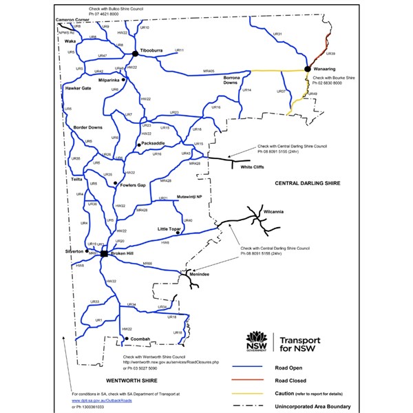
NSW unincorporated area
Or call the Roads & Maritime
Services Broken Hill Works Centre on 08 8082 6699 during business hours.
To the east of the unincorporated area, conditions reports are issued by shire councils. The image above shows roughly where they are and phone numbers. There are also website reports.
Bourke Shire
Click me
Central Darling Shire
http://www.centraldarling.nsw.gov.au/faqs/engineering/who-do-i-speak-to-in-regards-to-road-conditions.aspx
Qld
This is covered by three shires -
http://www.maphill.com/australia/queensland/simple-maps/political-map/
Bulloo -
https://www.bulloo.qld.gov.au/our-community/roads-traffic/road-conditions And also
Qld Main Roads -
Barcoo -
https://www.barcoo.qld.gov.au/environment-planning/disaster-management/road-conditions They also advise you contact local police before setting out.
Diamantina (includes
Birdsville) -
http://www.thediamantina.com.au/road-conditions Includes a link to SA outback road conditions and Qld Main Roads.
SA
Blessed simplicity -
https://www.dpti.sa.gov.au/OutbackRoads But not so quick - note the special notices link below the map.
Reply By: Michael H9 - Sunday, Feb 16, 2020 at 10:03
Sunday, Feb 16, 2020 at 10:03
Another warning to the unwary, I've driven those roads in a soft roader in wet weather and had an interesting problem. The wheel arches fill with mud which dries out due to the heat from the
wheels and it actually stops the
wheels from turning. The mud sets like concrete and it's a real bastard to remove it. I took the wheel nuts off once and still couldn't get the wheel off, all this while sitting in the mud myself. Soft roaders don't have spacious wheel arches like normal 4wds so the problem is pretty much restricted to them. Also the issue is worse in
places where the road is not as wet. The semi dried mud is stickier and sets quicker. If you're out there in something like an Xtrail or Forester then be warned. They're fine with the right tyres on those roads in the dry, but.....
AnswerID:
630078
Follow Up By: Sigmund - Sunday, Feb 16, 2020 at 11:07
Sunday, Feb 16, 2020 at 11:07
Yes.
I'm told the dirt is mostly a mix of clay and sand, and that makes them slippery too.
You can get into a waltz if you try them towing. Nerve wracking.
FollowupID:
905299
Reply By: rumpig - Sunday, Feb 16, 2020 at 11:18
Sunday, Feb 16, 2020 at 11:18
We were out at
Bourke last Sunday when rain was all about the area, looked at doing
Darling River Run but found it very hard to find up to date road conditions as council offices are closed on weekends and updates last done on the Friday. We ended up phoning
Louth pub and
Menindee service stations to get proper road condition reports...at the time
Bourke end of
Darling River Run was showing as closed by council website and
Louth pub phone call confirmed that (We assumed as much as they'd had quite a bit of rain there) but bottom half of
Darling River Run was shown as open and call to
Menindee said they'd had 8mm of rain there and it wasn't a good idea. About 6 hours later on Sunday afternoon after detouring to
Cobar and onto
Wilcannia we passed the digital signboard that showed
Wilcannia to
Menindee was still open even though they'd had atleast 8mm of rain on it, Monday morning when council offices finally reopened the road was showing as closed. I pity those that ventured on towards
Menindee that day, if in doubt we phone something local like pubs and service stations or police stations even.
AnswerID:
630081
Follow Up By: Sigmund - Sunday, Feb 16, 2020 at 11:30
Sunday, Feb 16, 2020 at 11:30
Yeah, hard to beat up-to-date local info.
Sometimes with a bit of digging you can get the number of the road maintenance supervisor in a locality.
It also has to be noted that you'll fail with some minor roads. I got stuck for 3 days waiting for the Newhaven property access road to dry when I took a punt on getting out there.
FollowupID:
905301
Follow Up By: rumpig - Sunday, Feb 16, 2020 at 11:41
Sunday, Feb 16, 2020 at 11:41
Yeah we also looked at taking a minor road South out of
Cobar rather then venturing towards
Wilcannia direction, road reports showed it as being open but a quick stop in at
Cobar information centre to use a
toilet as we were leaving town had the lady there telling me they'd also had 8mm of rain down that way also...pot luck was all that stopped us heading off along that road.
FollowupID:
905304
Reply By: Rangiephil - Sunday, Feb 16, 2020 at 17:34
Sunday, Feb 16, 2020 at 17:34
Several years ago was in the servo in
Tibooburra and saw that the cop closing the
Broken Hill Road at
Packsaddle Station.
I wanted to go to
White Cliffs so quickly left and turned onto the road before
Packsaddle where it was dry.
Well It rained and rained soon after I turned off the main road where it was dry..
I was towing my camper trailer , and had to line up every
grid and accelerate to ensure the camper was in line,as it moved form side to side. Every dip was full and it was magic to see
the desert covered in
water.
At
White Cliffs I had to remove a foot of mud from the front of the camper, and the next day chipped all the mud out of the wheel arches, and also the inner rim of each wheel where about 1 inch of mud had built up.
The high points were the incredible variety of animals and birds who came to the short lengths of bitumen before some of the grids. I had about 30-40 Apostle birds which refused to move from one of the puddles and foxes , roos etc.
Just near the end I came upon a cattle semi going towards
Packsaddle and told him to go into the nearby station. He ignored me and I heard later a grader had to pull him out of the drain the next day.
I was debating whether to find high ground and stop but there wasn't any .
It made a memorable trip.
AnswerID:
630085