V4 ExplorOz Traveller released now

V4 is now available on all platforms.
Michelle Martin
Marketing & Customer Support
I.T. Beyond Pty Ltd / ExplorOz

Lifetime Member
My Profile  My Blog  My Position  Send Message
Moderator

Back Expand Un-Read 3 Moderator

Reply By: Fiona & Paul - Friday, Aug 21, 2020 at 14:30

Friday, Aug 21, 2020 at 14:30
Thanks Michelle - update installed on my android and works fine for me. Regards Paul H
Paul H
OZ Downunder

Lifetime Member
My Profile  My Blog  My Position  Send Message

AnswerID: 633067

Reply By: Member - Bruno F - Saturday, Aug 22, 2020 at 08:56

Saturday, Aug 22, 2020 at 08:56
Thanks Michelle. Installed on my Tablet and 'phone (android). Both work OK. Big test starts tomorrow!
Cheers,
Bruno
AnswerID: 633073

Reply By: Member - Jim S1 - Saturday, Aug 22, 2020 at 11:35

Saturday, Aug 22, 2020 at 11:35
Downloaded itself to my iPhone and iPad last night. Hope to use it in a few weeks.

Cheers
Jim
"Sometimes I sits and thinks, and sometimes I just sits." A fisherman.

"No road is long with good company." Traditional

Lifetime Member
My Profile  My Position  Send Message

AnswerID: 633074

Reply By: Member - Nordave - Saturday, Aug 22, 2020 at 18:06

Saturday, Aug 22, 2020 at 18:06
Having a problem on iOS After the update . Maps under level 13 are really blurry and unreadable. I have tried closing and reopening the app.
AnswerID: 633078

Follow Up By: Member - Jim S1 - Saturday, Aug 22, 2020 at 19:27

Saturday, Aug 22, 2020 at 19:27
Everything beautifully crisp and clear on my iPad.

Cheers
Jim
"Sometimes I sits and thinks, and sometimes I just sits." A fisherman.

"No road is long with good company." Traditional

Lifetime Member
My Profile  My Position  Send Message

0
FollowupID: 909993

Follow Up By: Member - Nordave - Saturday, Aug 22, 2020 at 20:44

Saturday, Aug 22, 2020 at 20:44
Deleted program and reloaded. Problem solved
2
FollowupID: 909994

Follow Up By: Member - Jim S1 - Sunday, Aug 23, 2020 at 06:04

Sunday, Aug 23, 2020 at 06:04
Great stuff Nordave. Computers sometimes need a little help when they get things mixed up.

Cheers
J
"Sometimes I sits and thinks, and sometimes I just sits." A fisherman.

"No road is long with good company." Traditional

Lifetime Member
My Profile  My Position  Send Message

0
FollowupID: 909995

Reply By: TrevorDavid - Saturday, Aug 22, 2020 at 19:25

Saturday, Aug 22, 2020 at 19:25
Hi Nordave,

Try powering down (reboot) your device, count to eleven, then turn it back on. Worth a try

Regards

TrevorDavid


dontyajustluvit

Lifetime Member
My Profile  My Position  Send Message

AnswerID: 633079

Follow Up By: terryt - Sunday, Aug 23, 2020 at 08:39

Sunday, Aug 23, 2020 at 08:39
I've found I get better results if I count to ten
0
FollowupID: 909996

Reply By: Myo P - Tuesday, Sep 15, 2020 at 14:16

Tuesday, Sep 15, 2020 at 14:16
And still limited to 144k/Zoom12 offline? After using Locus and with various offline/downloadable/cached maps at zoom 15 or better, I am not going back to zoom 12. Seriously, I think it's crazy to have so much content unaccessible in the majority of Australia where there is no phone coverage.
AnswerID: 633411

Follow Up By: ExplorOz Team - Michelle - Tuesday, Sep 15, 2020 at 17:26

Tuesday, Sep 15, 2020 at 17:26
The offline EOTopo maps are actually built to include ALL data layers at the 144K level so there is nothing missing, nothing inaccessible between that level and the higher online levels. What you do get online when you view higher zoom levels is more space between the data to allow different styling of lines, fonts and labels, shading etc.

At 144K, the map shows 1km scale. If you're travelling at 100km/hr that means you'll travel the distance of the 1km scale bar in 36 seconds. Sometimes that is too fast to see on the map - ie. your position is flashing too fast across your screen so you will dial back the zoom to a higher scale (ie. lower zoom level).

In reality, those that have been driving with EOTopo maps in the outback know that the map detail is excellent and in fact you will find yourself dialing down the level below max zoom levels to see more of the road ahead to avoid getting caught out by bends in the road which at full zoom you don't tend to see as you're zoomed in too close. Also, in reality, if you're looking for a turn off, you will dial back the zoom also to avoid overshooting. You need time to apply the brake - you won't see this if you're zoomed in too close.

Have you used EOTopo offline maps in the outback yourself to know this firsthand?

Here are some photos using 144K offline in a vehicle in the bush - one is a small screen (Android phone) and in portrait orientation and the other is a 10" Android tablet indash. Both show the same raster map at 144K scale. At the time of this photo, the 144K was shown on Level 13 with overzoom on 14 - the zoom numbering has since changed with the new map engine since version 4 but the data is the same at 144 on both the 100% clarity level and the next zoom level (overzoom is just an enlargement).

The point of this example is to show you how much screen size affects what you see. But the map itself is the same data.
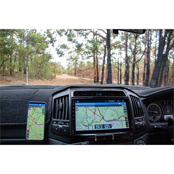


I can show you more similar examples - we do this in our field testing. We use the product offline in the bush and know what the levels and scale means in reality when your exploring in the bush.

The image below shows 144K offline (again using the old level number of 13, which now is shown as Level 12). You can see the rock on the right that we are driving around out the window is also on the map - that helps you understand the scale of reality.
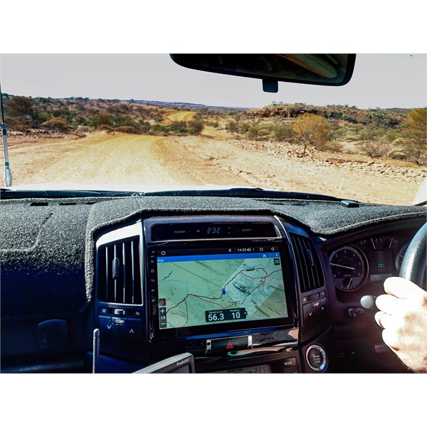


This next one is the main road heading from Tom Price to Karijini. We are sitting on 115km/hr and you'll see in the bottom right the little scale bar showing 1km. We will travel this distance in 36 seconds so compare this to the road shown on the map to appreciate how much you are seeing at 144K. Also note in this photo you can see the terrain out the window matches the terrain on the topo map.
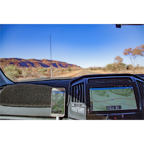


And finally, keep in mind that the offline EOTopo is a raster map product which means it is made up of a fixed number of pixels to draw the image. How your device displays an image of a fixed pixel size is determined by your screen size AND the screen resolution of that device. And furthermore, our app automatically knows the size of your screen and optimises the map display to suit your device. That is how people with small screens can view the exact same boundaries of a map viewed at Lvel 12 as someone viewing Level 12 on a larger monitor. As my images above demonstrate.
Michelle Martin
Marketing & Customer Support
I.T. Beyond Pty Ltd / ExplorOz

Lifetime Member
My Profile  My Blog  My Position  Send Message
Moderator

0
FollowupID: 910455

Follow Up By: Myo P - Tuesday, Sep 15, 2020 at 18:50

Tuesday, Sep 15, 2020 at 18:50
I'm baffled why you think people would only want to use this in their car doing 100km/h. You don't want people to use whilst biking/hiking?
Here's the thing, at Z12, at least for the web display, there are no contour line heights, the res is too low to display them. There are some at Z13, but not enough, at Z14 it's usable. Added to that at Z12 POIs are grouped and a PITA to select, at Z13 they mostly separate.
If >Z12 is so useless why do I so often use 13-15 regularly on my 60" TV where I have a ton of real estate?
Finally, as I said, I use Z15 on my phone with Locus Maps all the time, the *only* reason I am even engaging in this discussion is you have some unique POIs.

Congrats on a head unit that displays EOTopo, certainly Android auto won't since Google wont allow it, I have to view it on a 4" phone screen, another reason I need the higher zoom.

>Have you used EOTopo offline maps in the outback yourself to know this firsthand?
Nope, not paying until I think it will work as need it to.
0
FollowupID: 910458

Follow Up By: ExplorOz Team - Michelle - Wednesday, Sep 16, 2020 at 14:51

Wednesday, Sep 16, 2020 at 14:51
Myo P - didn't you see the latest newsletter?

Open the Latest Newsletter Online click here You will see it's all about using our maps for hiking, cycling and even horse riding. I have used the maps and app offline hiking frequently so I know first hand how it works.

I don't care if you have a preference for another map source - that's your personal choice but I am concerned about ensuring that incorrect statements about our product are addressed which is the purpose for my replies.
Michelle Martin
Marketing & Customer Support
I.T. Beyond Pty Ltd / ExplorOz

Lifetime Member
My Profile  My Blog  My Position  Send Message
Moderator

0
FollowupID: 910464

Follow Up By: Myo P - Wednesday, Sep 16, 2020 at 18:31

Wednesday, Sep 16, 2020 at 18:31
I don't have a preference, and I would like to use your app, but since it's not cheap and is a subscription I need to be sure it offers what I need.

Zoom 12:


Zoom 15:


At zoom 12 you cannot even see the 50m switchback, (which would be) under the text 'Mo' on the far right, yet is clear at Zoom 15, and 50m on a rocky walking trail is not insignificant. Note also contour heights are visible now.

Zoom 12 POI:


Zoom 13 POI (not grouped and tracks/roads through campground are clear):


Zoom 15 POI/tracks - buildings visible now:


Again I ask, if greater than Zoom 12 is not needed offline then why offer it online? Clearly it is of benefit. The only reason I can see for not offering it is data usage, which is pretty easy to allow user control of that. I have the entire state map in satellite data to Z16, phone storage space is not a concern to many of us. I like your POIs, I like the users sharing them, but if I can't display them clearly...
0
FollowupID: 910466

Follow Up By: ExplorOz Team - Michelle - Friday, Sep 18, 2020 at 11:34

Friday, Sep 18, 2020 at 11:34
Myo P,
The ExplorOz Traveller app is a once only payment of $59.99 from the app store and there is no subscription. The offline map licence is sold separately for $49.99 for the whole of Australia and is also a once off payment - there is no subscription.

The only subscription component in any of the ExplorOz products is the Membership/Tracking service. Membership has numerous entitlements but the main one is use of the Tracker which requires use of either the free standalone app (ExplorOz Tracker) or the Navigation & Mapping app ExplorOz Traveller which includes the Tracker that only Members can enable.

Membership costs are $49.99 for a 12 month subscription - and this does not auto renew. However, we offer a $20 discount off this price to people that have already purchased the ExplorOz Traveller app. So a 12 month Membership is only $29.95 if you are a Traveller app user.

App -$59.99
Optional extras: offline maps $49.99, and Tracker/Membership $29.95

All this and more is covered on the ExplorOz Traveller webpage. You can contact us privately for your specific queries on the Help Desk (link in footer of website).
Michelle Martin
Marketing & Customer Support
I.T. Beyond Pty Ltd / ExplorOz

Lifetime Member
My Profile  My Blog  My Position  Send Message
Moderator

0
FollowupID: 910478

Sponsored Links