EO Traveller routing
Submitted: Thursday, Feb 11, 2021 at 16:31
ThreadID:
141061
Views:
6509
Replies:
2
FollowUps:
2
This Thread has been Archived
Member - Warren H
I've been having some issues when loading private treks, where, when loading, every turn is recalculated. This occurs when poorly defined tracks are part of the route. Michelle had some suggestions that helped but it still seems a function of
routes that include poorly defined tracks. One of the workarounds suggested was to set the travel mode as cycling. This revealed some interesting things about the routing. The routing algorithm gives you a different path for driving versus cycling mode, with the route segments shorter for cycling. Driving generally follows the track marked on the map whereas cycling mode more closely follows the actual track you can see in the sat image. Interestingly the return journey for driving follows a slightly different path for the two trips. Note, I have been calculating detailed
routes including side trips to get a good handle on the overall distance to aid fuel calculations. Generally when driving I only use EO Traveller as a tracker to see my position not for turn by turn navigation. The screen shots comparing the
routes near
Goyders Pillar is shown below.
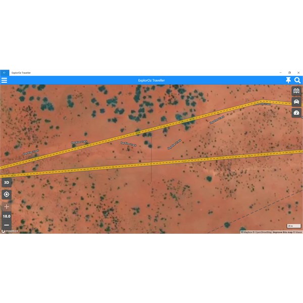
Driving

Cycling
Reply By: ExplorOz Team - Michelle - Thursday, Feb 11, 2021 at 20:08
Thursday, Feb 11, 2021 at 20:08
HI Warren
I can explain this further for you too...
The building of navigation in the app is done in segments - ie. Place to Place. The app uses an internet lookup in the MapBox system (not our software but an online tool universally used by many auto routing systems). It doesn't know a thing about our maps but has a database of road data it uses to calculate your route to navigate between the 2 selected
Places.
Most of the time the data it extracts is spot on - even in outback areas, however in outback areas it can also be a bit patchy for various reasons that are often hard to determine except by trial and error. We aren't 100% sure if the reason is that MapBox has to restrict the system from auto routing every road as "driveable" due to liability issues (eg. areas that are prone to flooding) or if their data just actually doesn't have complete data for areas.
What we do know is how the auto router works. It has to find road "attribution" data in its database for every segment between every
junction of a road/track for the whole length of segment you are asking it to calculate. Problems occur when one tiny bit of road attribution is missing - hence a whole segment can be rejected when in fact the issue is only due to a much smaller area of road info missing. So sometimes its a matter of high zoom investigation to locate the problem spot and just insert an extra Place to break that segment into two either side of
the junction or
river crossing and then you'll find that you'll get "driving" calculations for either side of the problem bit - and therefore shorten the section you need to use other modes for. Sometimes even Cycling wont work and you'll need to use "straight" so obviously you want to try to keep that segment as short as possible. When I was making a Trek Note last year, I found a problem section was just 30m long across a dry
creek bed for which no other mode would work except "straight" but that's fine!
In fact, I think when you've requested "Driving" it has used "Straight" to fudge when it was within tolerance of 30m of inaccuracy via Driving for a problem spot. Not sure - but good that you are experimenting. There is always a way.
I have some ideas for further improvement of the system to add in future updates too.
AnswerID:
635032
Follow Up By: djm67 - Thursday, Feb 11, 2021 at 21:19
Thursday, Feb 11, 2021 at 21:19
Found a similar issue when trying to plan a club day, the map would not route me along Grigors Rd from south (-26.762030, 152.635665) to north (-26.703808, 152.684550). No matter how many way points I added, it did a u-turn about halfway and sent me on a 70km detour to travel about 10km.
FollowupID:
912492
Follow Up By: ExplorOz Team - Michelle - Thursday, Feb 11, 2021 at 21:21
Thursday, Feb 11, 2021 at 21:21
So instead of using the Driving mode, you would just need to change to another Mode to get the route line the way you wanted to go. Obviously there was no "turn by turn" data for that segment in the system for "driving".
FollowupID:
912493
Reply By: Member - Dick K - Thursday, Mar 11, 2021 at 12:16
Thursday, Mar 11, 2021 at 12:16
Just wandering if this problem had been addressed in the latest update or do we have to wait until the next update. There are plenty of marked tracks that can't be made into treks no matter what modes I set it to. (walk, cycle etc. Very frustrating.
AnswerID:
635530