Map Conversion Problems
Submitted: Friday, Nov 05, 2021 at 05:40
ThreadID:
142809
Views:
7732
Replies:
3
FollowUps:
8
This Thread has been Archived
Gwadir
Hope to get some community help for this problem, I have a series of maps that are in .qct format. If I open them with Memory Map I can view them fine. I want to make them usable of OziExplorer so I previously was put onto a copy of OziMapTrans which we thought would be able to open and convert the maps to .tif which would then allow me to convert them to ozf2 or ozf3 format but when I tried this it was as if every (for want of a better description) second tile was blank. I then downloaded Global Mapper which has the ability to open .qct files but same thing, pictures of the result attached. If you zoom in as in the second screen capture you can see that every other tile has all the info there its just that each adjoining tile is blank. Am I doing something wrong or have I got an incorrect setting, any help will be greatly appreciated.

Lakefield NP Full Map
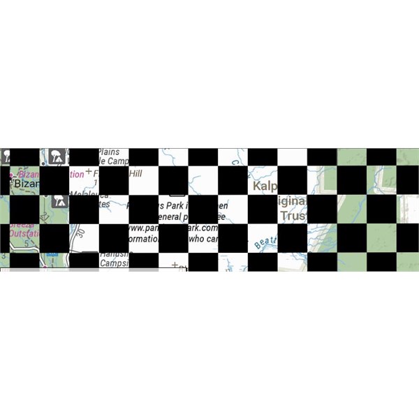
Lakefield NP Zoomed in
Reply By: SCUBADOO - Friday, Nov 05, 2021 at 19:06
Friday, Nov 05, 2021 at 19:06
I have converted many .qct files to OziE format over the years using OziMapTrans and a few other programs with success however MemoryMap have just like OziE and others have introduced some encryption into more recent maps in an attempt to limit use for legitimate users only.
If your map files fall into the latter category you will probably be unsuccessful in attempts to convert into other formats.
Any chance of posting one of your files online somewhere for us to check the format?
I have used mediafire.com for years to safely store my files.
AnswerID:
638511
Follow Up By: SCUBADOO - Monday, Nov 08, 2021 at 13:24
Monday, Nov 08, 2021 at 13:24
Unfortunately that map is part of the "Hema 4WD Maps 2020" mapset and is protected (encrypted) by Memory-Map for use post purchase.
On my Memory-Map app it displayed exactly like your conversion results.
I then enabled a 10 day trial and the map displays perfectly.
I think you are stuck with the mapset for use solely within Memory-Map.
FollowupID:
916981
Follow Up By: Gwadir - Tuesday, Nov 09, 2021 at 05:40
Tuesday, Nov 09, 2021 at 05:40
Thanks Scubadoo, that's a bugger, was hoping to be able to use it on my Polaris in car GPS using OziExplorer. I might have to think about getting the professional version of MM so I can print the maps out at full size, then I can scan them as .tif's and geo-reference them that way. Thanks for what you did.
FollowupID:
916986
Reply By: Member - Boobook - Saturday, Nov 06, 2021 at 07:59
Saturday, Nov 06, 2021 at 07:59
Those tiles look like the encrypted files for MM when not licenced.
AnswerID:
638514
Follow Up By: Gwadir - Monday, Nov 08, 2021 at 05:38
Monday, Nov 08, 2021 at 05:38
Thanks for the reply Boobook, those screen captures were of files I had purchased through Memory Map. Like I said in my post, I can open them no problem using Memory Map but when I try to open them using Global Mapper which can read .qct files that is the result.
FollowupID:
916979
Follow Up By: The Explorer - Tuesday, Nov 09, 2021 at 14:18
Tuesday, Nov 09, 2021 at 14:18
Hi - I think that is Boobooks point - they are probably licenced for use with MM only, they are not licenced for use in other programs and are therefore "encrypted" so they cant be copied (easily).
Cheers
Greg
| I sent one final shout after him to stick to the track, to which he replied “All right,” That was the last ever seen of Gibson - E Giles 23 April 1874 Lifetime Member
My Profile My Blog Send Message
Moderator |
FollowupID:
916991
Reply By: Member - mike g2 - Thursday, Dec 02, 2021 at 11:05
Thursday, Dec 02, 2021 at 11:05
see hema notice:
copyright ref
and:
govt maps - ? free
etc....google earth, zoom earth
more sat maps
bieng a military man...
army maps
would not be surprised if hema protected their files, its good commercial practice
MG
mil maps AUS.
AnswerID:
638754
Follow Up By: Gwadir - Friday, Dec 03, 2021 at 06:27
Friday, Dec 03, 2021 at 06:27
Thanks for that Mike, yeah I've got into the topo's from Geoscience Australia, 1:25K, 1:50K & 1:100K which are good. I've also scanned in a lot of National Parks maps from around oz. I've been going through the Avenza maps which cover a lot of other areas and HEMA.
FollowupID:
917493
Follow Up By: Member - mike g2 - Friday, Dec 03, 2021 at 10:04
Friday, Dec 03, 2021 at 10:04
hi again- i used a tool in win 10 called snip to get this sample from Satellite view:
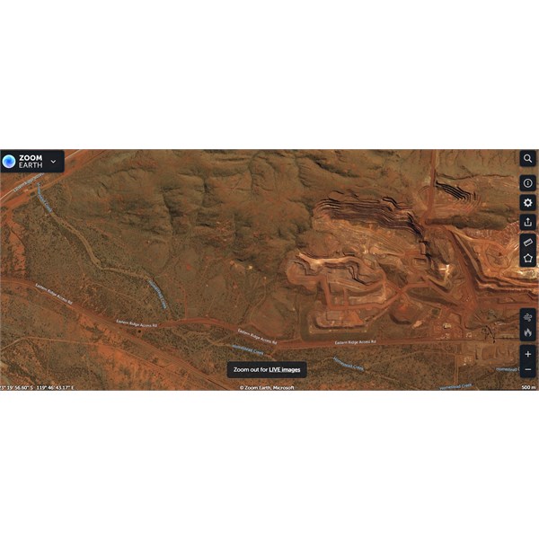
Sat view, Newman
you will see excellent detail and geo ref. a lot of this country has been stored by sat or ariels, mainly for oil/gas/ mining. exploration .
MG.
FollowupID:
917502
Follow Up By: The Explorer - Friday, Dec 03, 2021 at 17:42
Friday, Dec 03, 2021 at 17:42
If you want georeference sat images (google earth/arcgis/MS virtual earth etc) try
MOBAC
You may have to do a bit of "research" to aquire desired map sources but works a treat for OziExplore ready to go images.
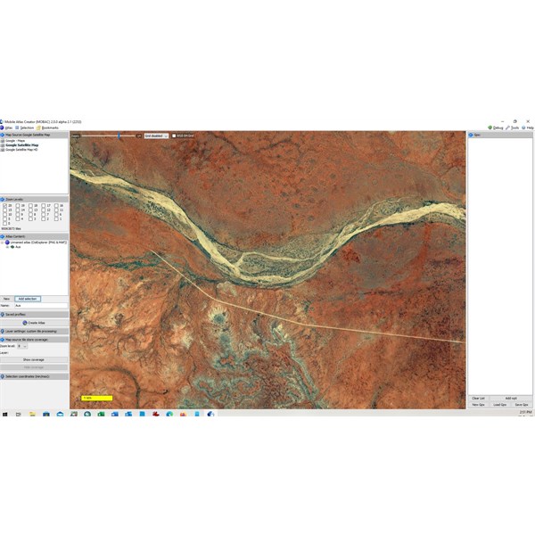
MOBAC Google
Cheers
Greg
| I sent one final shout after him to stick to the track, to which he replied “All right,” That was the last ever seen of Gibson - E Giles 23 April 1874 Lifetime Member
My Profile My Blog Send Message
Moderator |
FollowupID:
917505