Camping on Sandy Blight Junction Road
Submitted: Thursday, May 18, 2023 at 19:34
ThreadID:
145658
Views:
3488
Replies:
4
FollowUps:
3
This Thread has been Archived
Member - Kenny M
I'm in a convoy of 4 camper trucks and have come half way down Sandy Blight
Junction Rd.
Currently stopped at a Wikicamps
bush campsite about 81km (straight line) from GCR.
Its pretty slow going in the trucks so wont make it to Grt Central Rd tomorrow.
Easy for a single truck to find a spot but not so easy for 4.
Does anyone know of good spots heading South towards CGR? Eg Bungabiddy Rick Hole.
Thx
gGary Jntn Campsite
Reply By: Bob Y. - Qld - Thursday, May 18, 2023 at 21:21
Thursday, May 18, 2023 at 21:21
From what I recall, it’s not much of a
camp up at the turnaround, near the Spring.
But back towards the SB, there’s an area there that may suit your group? Few trees & a bit of scrub I think?
Just for the record, there is a
good camp back up at a pump, towards the
border crossing. There was a group already camped at the pump so we went further into the scrub & found a spot big enough for our 4 vehicles.
Bob
AnswerID:
643620
Follow Up By: Member - Kenny M - Saturday, May 20, 2023 at 08:50
Saturday, May 20, 2023 at 08:50
Thanks Bob - nailed it!
FollowupID:
923328
Reply By: ExplorOz - David & Michelle - Friday, May 19, 2023 at 11:23
Friday, May 19, 2023 at 11:23
Probably a bit late to reply now for you, but you say you are using WikiCamps but I presume you also have the
ExplorOz Traveller app with the offline
EOTopo maps? If so you should be able to see a few markers that others have put with comments, plus the
Bungabiddy Rockhole Camp and info which says:
The access road into this area is narrow and rocky. It ends at this point, where most people make
camp (
free bush camp, no facilities) but you are still about 300m from the actual
rock pools, which Len Beadell documented as having crystal-clear
water. To reach the
rock pools you will need to walk. Near the car
park area, there is an old blazed tree, believed to have been made by Frank Hann in 1904.
Have fun, looks great. Love that area. Hope you took some drone footage of Mt Strickland etc.
AnswerID:
643622
Follow Up By: Member - Kenny M - Saturday, May 20, 2023 at 08:58
Saturday, May 20, 2023 at 08:58
Thanks. I scouted the track up to the last turning hole but the rest of the trucks stayed back and we camped in that 2nd site - very nice.
FollowupID:
923330
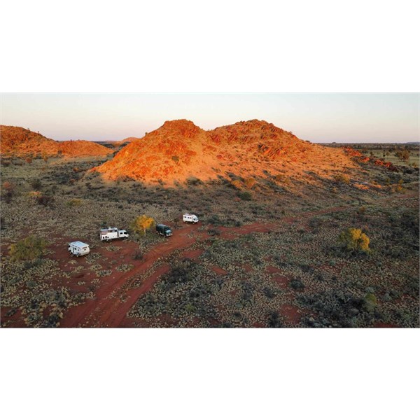
Reply By: ExplorOz - David & Michelle - Friday, May 19, 2023 at 12:46
Friday, May 19, 2023 at 12:46
HI Kenny, that's a great photo. Make sure you add it to
Places :) May I also post it to the Trek Note or destination promotion?
AnswerID:
643623
Follow Up By: Member - Kenny M - Saturday, May 20, 2023 at 08:51
Saturday, May 20, 2023 at 08:51
Hi David
Not my photo but ill ask.
Cheers
FollowupID:
923329
Reply By: Member - Kenny M - Saturday, May 20, 2023 at 07:51
Saturday, May 20, 2023 at 07:51
Thanks folks.
Found two
camp sites and a turning loop. The one at the road was pretty bleak and looked more like a youth's hangout, with a couple of trashed cars there.
Stayed at the 2nd site, which is the one around 300m from the spring.
I did drive my truck to the end of a narrow and very rocky track, across a dry river bed and people had camped up there, right at the end. But not enough room for 4x 6.5T trucks.
Next, we'll head down Connie Sue then hope the
Canning Stock Route is clear enough for us.
AnswerID:
643631