Hay River Track
Submitted: Tuesday, Oct 03, 2023 at 14:51
ThreadID:
146343
Views:
4663
Replies:
5
FollowUps:
7
This Thread has been Archived
JA1
Hi Folks,
Planning to drive the
Hay River Track, north to south, in winter of 2024. The ExploreOz app has helped tremendously. For anybody who has done it, I'm trying to gauge the pace at which you would realistically be driving the track (assuming normal conditions)? I've set aside 4 days (3 nights) averaging 30km/h.
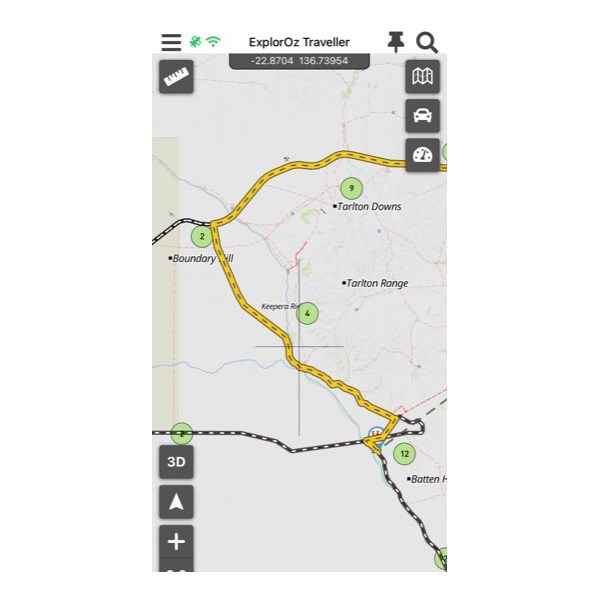
Also, does anybody know if you can drive the road in the photo below, connecting the Plenty H'way and
Batton Hill camp? It's about 4km west of
Arthur River campsites. HEMA says it's a private road but ExploreOz suggests it. I can't find a name for the road so assume it is a private road. I'd ideally like to drive it as I'll be coming from
Boulia.

Hay River
Reply By: Life Member - Duncan W (WA) - Wednesday, Oct 04, 2023 at 11:18
Wednesday, Oct 04, 2023 at 11:18
G/day JA1. The track is a good scenic route to take and easily followed. In the year we did it we had the diversion at Eyre
Creek (we travelled south to north). If coming in from the north via the Plenty Hwy, there is a
sign directing you to Batton
Camp so hard to miss. The track from the intersection to Batton
Camp was horribly corrugated, may have been graded when you do it. When we got to Batton
Camp the owners where no where in sight so we continued on instead of
camping there.
Overall, the biggest annoyance if you could call it that was the whoopsie doos in the otherwise track, which stopped you getting up any speed. Your estimate of 30km/hr is pretty close to the mark.
In the year we did it the areas around the
Hay river river course was like being in a garden it was that green, and small birds flitted here and there constantly.
Water is available at
Dingo Well/
Bore and we saw 2 beautiful dingoes near here.
Lake Caroline is a nice diversion and
camping through this section is plentiful.
We really enjoyed the trip and would do it again.
Enjoy.
AnswerID:
644552
Follow Up By: JA1 - Wednesday, Oct 04, 2023 at 11:34
Wednesday, Oct 04, 2023 at 11:34
Hi Duncan,
Thanks for the info - very helpful. I had heard
Batton Hill camp was no longer running (due to the impact of COVID apparently). I'm not overly concerned about the pace of the track but it's obviously handy to know for planning purposes. Thank you for the
water info too - great to know. From what I've read and watched, it certainly appears to be the picturesque track of the Simpson - we can't wait!
Cheers!
FollowupID:
924691
Reply By: Member - mechpete - Wednesday, Oct 04, 2023 at 15:34
Wednesday, Oct 04, 2023 at 15:34
3 ngts
camping will be plenty an not rushing it
Cheers mechpete
AnswerID:
644553
Reply By: Rob A1 (SA) - Thursday, Oct 05, 2023 at 15:56
Thursday, Oct 05, 2023 at 15:56
Here's the link to the permit system operated by the CLC
https://www.clc.org.au/permits/#apply-for-entry-permit. That page also has some contact numbers and other stuff.
We were the second group to travel that track way back when Lindsay Bookie was still the TO and Joe Fleming his offsider was organising stuff and helping to get it all going properly. Having travelled NS and SN it can be a pretty trip but if there's no track maintenance been done the bush pin striping can be pretty horrific as the scrub can and does grow back over the worn tracks after decent rains.
You will need to carry enough fuel to get you from
Jervois Station to Birdsville/Mungaranie/Mt Dare.
There was plenty to see around Baton
Hill but that was some time back and if it has been wet the track out to
Lake Caroline is very soft
Enjoy the journey
Rob
AnswerID:
644567
Follow Up By: JA1 - Thursday, Oct 05, 2023 at 21:40
Thursday, Oct 05, 2023 at 21:40
Thanks for the input Rob. Will have close to 200L diesel and already have a few bush pinstripes much to the dislike of my wife ??
FollowupID:
924701
Reply By: Allan B (Sunshine Coast) - Friday, Oct 06, 2023 at 10:59
Friday, Oct 06, 2023 at 10:59
.
Hi JA1,
When I travelled north on the
Hay River Track a few years back, I asked Jol Fleming about using the track you refer to when continuing to
Boulia. He told me quite abruptly that I could not as it was a private road and that I must exit via the continuing
Hay River track westward to the Plenty Rd
junction near
Jervois Station.
It was not marked as "private" on a map I had but I chose not to argue with Jol Fleming. I seem to remember StephenL telling me that it was a station track and permission could be obtained from the station but I have no details. Perhaps Stephen may see this and comment?
Other than that, I would say that the
Hay River Track is one of the best drives I have made. A bit twisty through the dry river bed in
places and a few soft sandy spots but no problem for the Troopy. 3 days travel for us. Somewhat dissapointing at Batton
Hill campground and dealings with Jol Fleming not good but I don't think he is involved anymore.
AnswerID:
644569
Follow Up By: JA1 - Friday, Oct 06, 2023 at 17:22
Friday, Oct 06, 2023 at 17:22
Thanks Allan,
I had planned to go along the track from Jervois but thought I’d try to see if this other track is usable. I can’t wait to drive the track and am not concerned about the state of Battin
Hill camp. Thanks for the info, Cheers!
FollowupID:
924709
Follow Up By: Stephen L (Clare) SA - Friday, Oct 06, 2023 at 18:13
Friday, Oct 06, 2023 at 18:13
Hi Allan
You are 100% correct and the said land in question is not , or was not then Aboriginal land but part of Tarlton Downs who actually own the land that
Goyders Pillar is located on.
From memory Lindsay used to charge $50 per person to visit this special feature and the money went straight into his pocket and Tarlton Downs never ever received a red cent or even gave them permission to go there, so go figure.
Cheers
Stephen
FollowupID:
924710
Follow Up By: Allan B (Sunshine Coast) - Friday, Oct 06, 2023 at 18:55
Friday, Oct 06, 2023 at 18:55
.
Thanks Stephen,
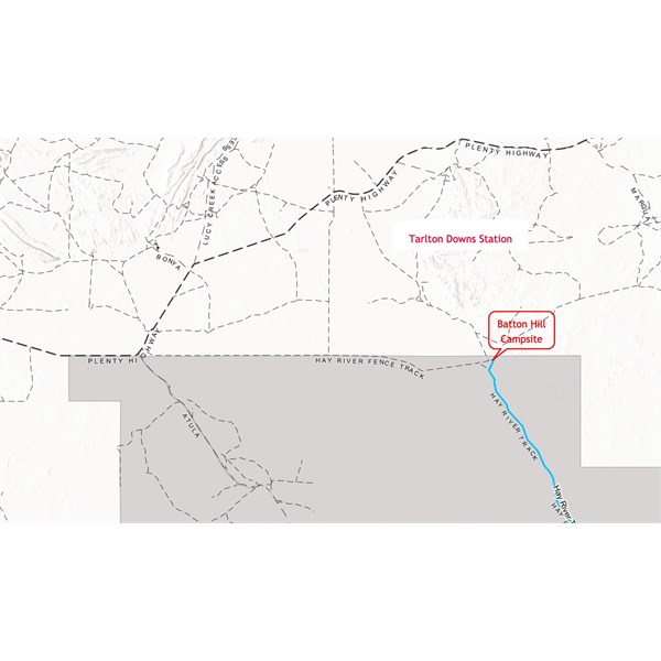
I thought that was the case. The map below is copied from a larger section on the CLC website and clearly shows the Aboriginal land coloured
grey. I added the red notations.

Batton Hill
FollowupID:
924711
Follow Up By: JA1 - Friday, Oct 06, 2023 at 22:51
Friday, Oct 06, 2023 at 22:51
Thanks Gents, very interesting. I’ll have to look into it further and see where things are at now.
FollowupID:
924712
Reply By: Gbc.. - Tuesday, Oct 17, 2023 at 10:52
Tuesday, Oct 17, 2023 at 10:52
I drove it solo three weeks ago. It is my new favorite drive in
the desert, much more going on than a standard crossing. I have heard from a number of sources that the T.O.'s intend to close it again - not sure how accurate that is.
When you book, you'll be put in touch with Lester Hamiton at Batton
Hill. He couldn't have been more helpful and sent me some extra links about track history and running notes etc.
As above, I asked at Tobermorey about the 'shortcut' from QLD too but got similar info, so it was on to Jervois and then 80 KM of character forming corrugations which found a few weak points in my canopy, draw slides and fridge slide - my fault entirely.
We accidentally scored that heatwave which saw up to 43 deg one day, so lazing about wasn't really an option. We got it done in a few cruisey if not a little long, days. We didn't see another soul until the QAA - except a guided tagalong tour who not so kindly closed the bloody
gate at Batton
Hill while we were waiting for them to faff about and get their brood of not so intrepids through same
gate....
AnswerID:
644623
Follow Up By: JA1 - Wednesday, Oct 18, 2023 at 12:39
Wednesday, Oct 18, 2023 at 12:39
Thanks for the feedback Gbc! It's proving hard to find people who have driven it recently (which is a good thing in my opinion). I'll hopefully be dealing with Lester then and look forward to those character forming corrugations haha. Hopefully we don't encounter the 43 deg days though - wow.
FollowupID:
924761