Bushfire - Gunbarrel Highway
Submitted: Wednesday, Sep 19, 2012 at 17:11
ThreadID:
98115
Views:
3792
Replies:
13
FollowUps:
3
This Thread has been Archived
equinox
Bushfire ADVICE for
Gibson Desert Nature Reserve, Gunbarrel Hwy in
the Shire of Ngaanyatjarra
ALERT LEVEL:
A bushfire ADVICE has been issued for people travelling on
Gunbarrel Highway in
Gibson Desert Nature Reserve in the Shire of Ngaanyatjarra.
The fire is burning along
Gunbarrel Highway between the
Eagle Highway and Gary
Highway, west of Mt Everard.
There is no threat to lives or homes. Although there is no immediate danger you need to be aware and keep up to date if you are travelling through this area.
WHAT TO DO:
· Stay alert and monitor your surroundings.
· Watch for signs of a bushfire, especially smoke and flames.
ROAD CLOSURES:
No roads are closed.
WHAT FIREFIGHTERS ARE DOING:
DEC is monitoring the fire.
CAUSE:
The cause of the fire is unknown.
AGENCY RESPONSIBLE:
DEC is managing the fire.

Bushfire Advice - Gunbarrel Highway
Reply By: Member - Toyocrusa (NSW) - Wednesday, Sep 19, 2012 at 20:32
Wednesday, Sep 19, 2012 at 20:32
Our local news tonight had Fire authorities warning that this summer could be one of the worst bushfire seasons for the Eastern and Southern states of Aus. since 1994. Hope they are wrong. Bob.
AnswerID:
495256
Reply By: Member - Duncan W (WA) - Thursday, Sep 20, 2012 at 09:40
Thursday, Sep 20, 2012 at 09:40
Alan when we were out there with Desert Discovery we had fires all over the place. The
main camp was on evacuation standby the day before I got there and we had fire watches on 2 nights. When heading out towards
Lake Christopher we saw a spinafex fire start from a reignition and within 10 minutes it was a raging inferno. As we drove around the
Rawlinson Range along the Gunbarrel Hwy we were being chased by fires and at one stage fire was either side of us up to the track.
Fortuantely the fires abaited in the 2nd week I was at
camp.
The TO's have been doing a great deal of prescribed and otherwise burning all through the Gibson & GVD areas. Literally everywhere we looked we saw fires.
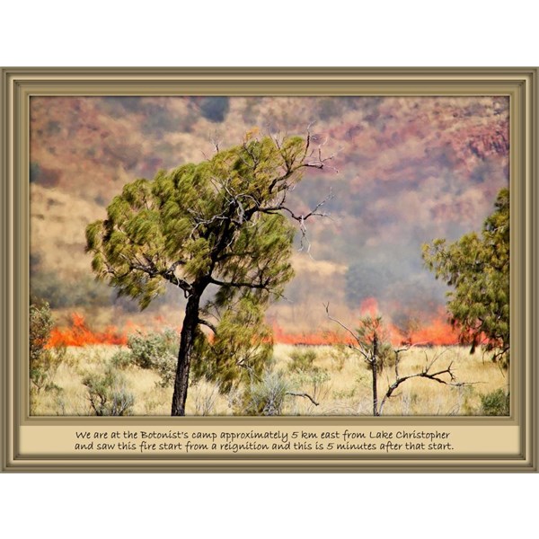
Spinafex fire Rawlinson Range
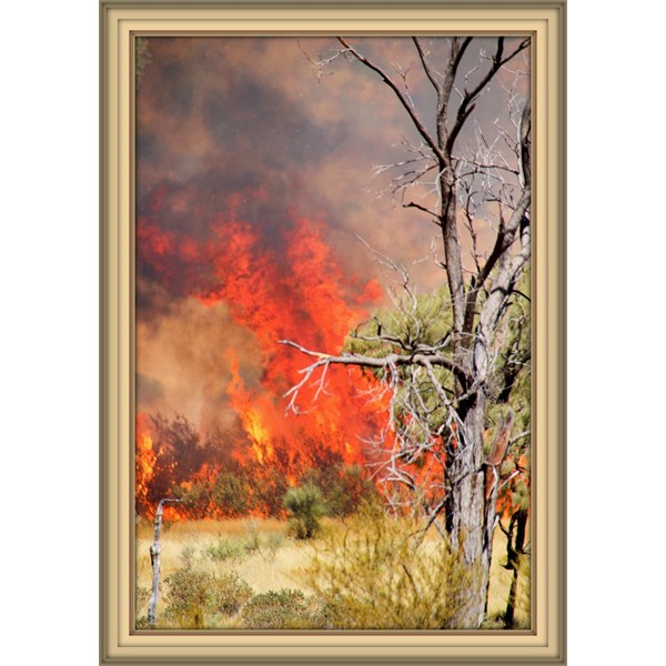
After 10 minutes
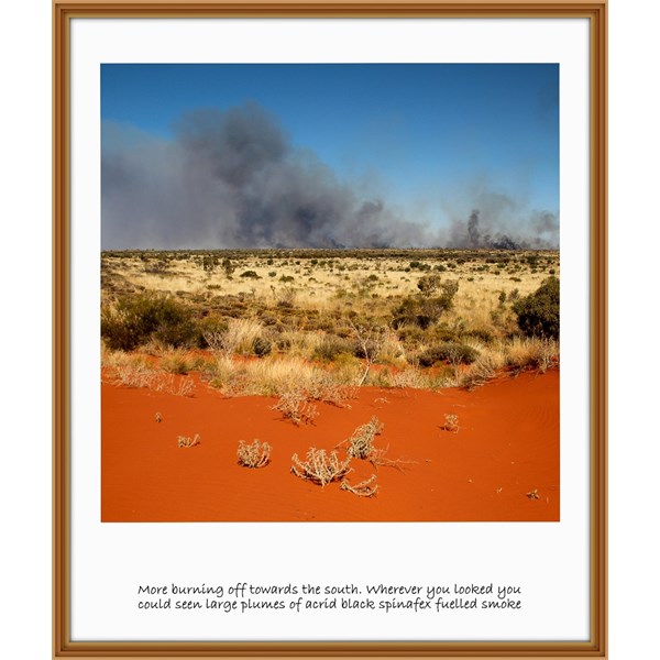
Fire seen from the GCR
AnswerID:
495293
Follow Up By: Rick (S.A.) - Thursday, Sep 20, 2012 at 11:00
Thursday, Sep 20, 2012 at 11:00
we saw quite a bit of burning north of the Talawana in July - we thought it was T/O's as there was no lightning or inclement weather.
Those pics of yours are fantastic, partly because of the flash framing!
Did you get to Circus
Water? - Alan may have sent you a photo of
mine, earlier in the year.
What is Desert Discovery all about?
Cheers
FollowupID:
770965
Follow Up By: Member - Duncan W (WA) - Thursday, Sep 20, 2012 at 14:46
Thursday, Sep 20, 2012 at 14:46
Hi Rick we went to Circus
Water on a number of occassions and the bird life was to be seen to be believed. One of the fires burnt in and around CW.
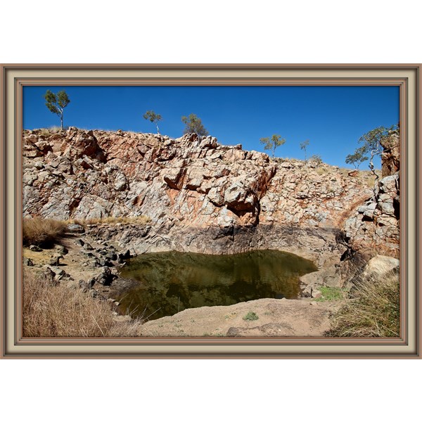
Circus Water
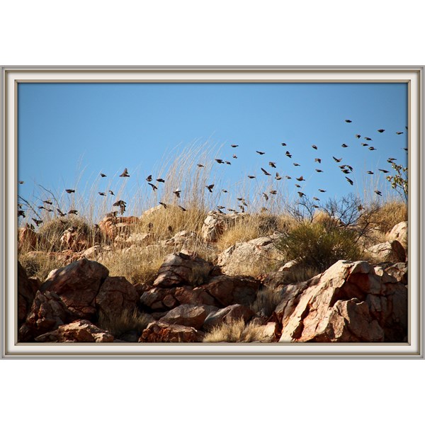
Birds in flight - finches
The framing is one of the functions available in Picasa 3
DD is a gathering of people doing various types of research in desert regions.
FollowupID:
770975
Follow Up By: equinox - Thursday, Sep 20, 2012 at 15:25
Thursday, Sep 20, 2012 at 15:25
Great pictures Duncan,
I wonder if the TO's have started this current fire, sounds like you had a couple of close calls.
Latest update was the same at 10:30am this morning - next update is a 4pm this arvo.
Cheers
Alan
FollowupID:
770981
Reply By: equinox - Thursday, Sep 20, 2012 at 19:15
Thursday, Sep 20, 2012 at 19:15
Revised ADVICE issued at 2:55pm.
It says more or less the same thing.
I'm not sure how the DEC are monitoring it....

Gunbarrel Fire Alert
AnswerID:
495320
Reply By: equinox - Friday, Sep 21, 2012 at 12:32
Friday, Sep 21, 2012 at 12:32
Latest advice from 9:50am, slightly changed, now mentioning the Gary Highway as
well.
"The fire is burning north and south of the
Gunbarrel Highway near
Everard Junction. It may impact on the
Gunbarrel Highway and Gary Highway over the next few days, north and east of
Everard Junction."

Gunbarrel Advice 21 Sept 9:50am
AnswerID:
495349
Reply By: equinox - Friday, Sep 21, 2012 at 18:07
Reply By: equinox - Sunday, Sep 23, 2012 at 13:28
Sunday, Sep 23, 2012 at 13:28
No change in the advice, however the cause has changed:
CAUSE:
The fire is suspected to have been caused by a re-ignition of a prescribed burn conducted jointly by DEC, Central Desert Native Title Service and traditional owners.

Gunbarrel Advice
AnswerID:
495473
Reply By: equinox - Sunday, Sep 23, 2012 at 19:02
Sunday, Sep 23, 2012 at 19:02
Here's a 2 day old Satellite picture of it.
From NASA -
HERE
A Hi-res picture (sort of) is available for download.
AnswerID:
495492
Reply By: equinox - Monday, Sep 24, 2012 at 13:16
Monday, Sep 24, 2012 at 13:16
Worst may be over:
@10:45am
ALERT LEVEL:
A bushfire ADVICE remains in place for people travelling on
Gunbarrel Highway
in
Gibson Desert Nature Reserve in the Shire of Ngaanyatjarraku.
The fire is no longer threatening the Gunbarrel and Gary highways however, warmer conditions expected in the next couple of days may again cause the fire to flare-up.

Gunbarrel Advice
AnswerID:
495537
Reply By: equinox - Wednesday, Sep 26, 2012 at 14:18
Wednesday, Sep 26, 2012 at 14:18
It's still going.
Extracts from latest advice at 11am:
The fire is burning along the
Gunbarrel Highway near Mt Beadell but is no longer
threatening the Gary Highway.
The fire is burning in remote spinifex country and is estimated to have burnt 1.4 million
hectares.

Gunbarrel Advice
AnswerID:
495680
Reply By: equinox - Saturday, Sep 29, 2012 at 17:54
Saturday, Sep 29, 2012 at 17:54
Still going, a week and a half later.
ALERT LEVEL:
A bushfire ADVICE remains in place for people travelling on
Gunbarrel Highway in the Shire of Ngaanyatjarraku.
The fire is burning east of the
Gunbarrel Highway, north of Mt
Beadell. The fire is burning in a westerly direction and may
impact the road in a few
places during the day.

Gunbarrel Advice
AnswerID:
495885
Reply By: equinox - Monday, Oct 01, 2012 at 16:07
Monday, Oct 01, 2012 at 16:07
2:00pm update.
ALERT LEVEL:
A bushfire ADVICE remains in place for people travelling on
Gunbarrel Highway in the Shire of Ngaanyatjarraku.
The fire is burning north of the
Gunbarrel Highway, west of
Lake Breaden. The fire is burning in a southerly direction
towards the highway and may impact the road in a few
places
during the day.

Gunbarrel advice
AnswerID:
496004
Reply By: equinox - Tuesday, Oct 02, 2012 at 19:04
Tuesday, Oct 02, 2012 at 19:04
Gunbarrel Highway to
Warburton now closed due to the fire!!
Presumable this means the
Heather Highway as
well.
ALERT LEVEL:
A bushfire ADVICE remains in place for people travelling on
Gunbarrel Highway in
the Shires of Ngaanyatjarraku and
Wiluna.
The
Gunbarrel Highway has been closed due to the possible impact of fire in the
next few days. There is no threat to lives or homes. Although there is no immediate danger you need to be aware and keep up to date if you are travelling through this area.
WHAT TO DO:
- Stay alert and monitor your surroundings.
- Watch for signs of a bushfire, especially smoke and flames.
ROAD CLOSURES:
The
Gunbarrel Highway has been closed from
Carnegie Station to
Warburton until further notice. For more information contact the Shire of Ngaanyatjarraku on (08) 8956 7966 or the
Shire of
Wiluna (08) 9981 8000.

Gunbarrel Advice
AnswerID:
496063
Reply By: equinox - Wednesday, Oct 10, 2012 at 15:23
Wednesday, Oct 10, 2012 at 15:23
Bush Fire All Clear.
ALERT LEVEL:
An ALL CLEAR has been issued for people travelling on
Gunbarrel Highway in
the Shires of Ngaanyatjarraku and
Wiluna.
The bushfire continues to burn in remote country and is no longer threatening the highway. DEC will continue to monitor the fire and may need to re-issue warnings if the threat returns.
The danger has passed but you need to remain vigilant in case the situation changes.

Gunbarrel All Clear
AnswerID:
496390