Maitland Downs to Maytown track
Submitted: Sunday, Oct 14, 2012 at 12:15
ThreadID:
98529
Views:
3676
Replies:
7
FollowUps:
8
This Thread has been Archived
equinox
Hi all,
Does anyone know what the track is like?
Is it a public access road and/or do you need permission?
What is the
Palmer River crossing like - is there a bridge or ford?
Thinking of next month, for the Eclipse (1 month today).
Any answers appreciated.
Cheers
Alan
Reply By: Member - Tony (ACT) - Sunday, Oct 14, 2012 at 12:51
Sunday, Oct 14, 2012 at 12:51
Yes its a public road, no permission required. The crossing is a natural rocky bottom.
It can get deep after rain and it twists and turnes a bit, thats the crossing below
Maytown. Not sure what the one upstream is like.
AnswerID:
496667
Follow Up By: equinox - Sunday, Oct 14, 2012 at 12:59
Sunday, Oct 14, 2012 at 12:59
Thanks Tony, that's great news.
I should have asked too (this area being totally foreign to me) - if there is
water and I have to walk over to check the depth, what is the likelihood of any lizards in the river.
FollowupID:
772367
Reply By: Rockape - Sunday, Oct 14, 2012 at 13:16
Sunday, Oct 14, 2012 at 13:16
Equinox,
Here is a photo of the crossing about 8 years ago and as you can see at this time of year it will be pretty dry.
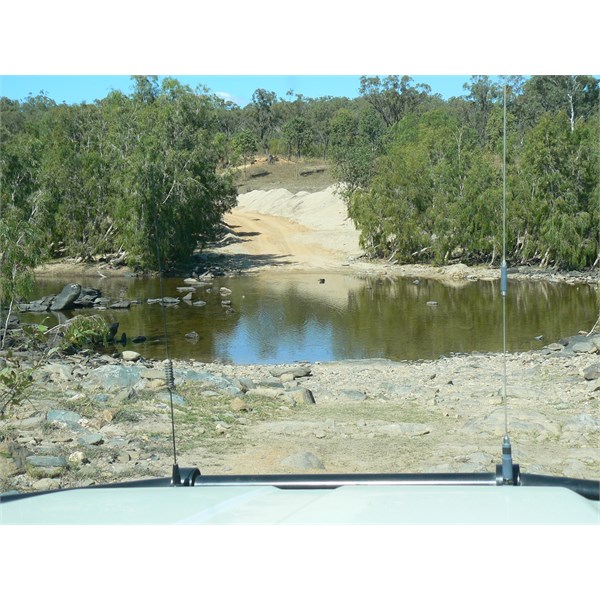
Palmer River
I wouldn't worry about ceckos.
Have a good trip,
RA.
AnswerID:
496669
Follow Up By: equinox - Sunday, Oct 14, 2012 at 13:30
Sunday, Oct 14, 2012 at 13:30
Thanks Rockape - doesn't look too bad!!
FollowupID:
772368
Follow Up By: Navigator 1 (NSW) - Monday, Oct 15, 2012 at 17:39
Monday, Oct 15, 2012 at 17:39
Thanks Rockape,
A picture is worth a thousand words. Rob
FollowupID:
772439
Reply By: A J - Sunday, Oct 14, 2012 at 13:27
Sunday, Oct 14, 2012 at 13:27
Alan - search the
forum for "Palmer River"as there was some problems up there recently. Also if you have time there is a book called "River of Gold" by Hector Holthouse which is very interesting - may have to buy from ebay.
A J
AnswerID:
496670
Follow Up By: equinox - Sunday, Oct 14, 2012 at 13:40
Sunday, Oct 14, 2012 at 13:40
Thanks AJ - I think you're referring to the "alleged" trigger happy landowner - I believe that is west of where I plan to go, however will investigate that situation a bit more both prior to and when I am in the area.
Will keep an eye out for the book.
Cheers
Alan
FollowupID:
772369
Reply By: G.B.T - Sunday, Oct 14, 2012 at 17:54
Sunday, Oct 14, 2012 at 17:54
Gooday Equinox,
Coincidently I was camped at
Maytown on the day of the alleged incident. You are
well clear of Palmerville Station there, and the road to
Maytown was being worked on by a team
who were camped at the crossing some kilometres from
Maytown itself. The road was in excellent condition, and that crossing was not difficult. It's the crossing to which the road leads, the one directly below
Maytown from memory being marked as unadvisable. Assuming that the river is not flooded, I cannot imagine you having any problems.
Cheers
Graeme.
AnswerID:
496676
Follow Up By: equinox - Sunday, Oct 14, 2012 at 20:41
Sunday, Oct 14, 2012 at 20:41
Thanks a lot Graeme - here's hoping for late rain!!!!
FollowupID:
772387
Reply By: Burnt Damper - Sunday, Oct 14, 2012 at 19:02
Sunday, Oct 14, 2012 at 19:02
Drop into the
Palmer River Roadhouse and talk to Karen or Andrew before traveling there they will be able to help for sure.
I am presently working on the
Maytown road with a road crew getting it ready for the people watching the eclipse. The first section into Tin
creek (abbots) dam will be finished in 2 weeks time.
AnswerID:
496677
Follow Up By: equinox - Sunday, Oct 14, 2012 at 20:43
Sunday, Oct 14, 2012 at 20:43
Hi Burnt Damper,
That is most helpful. Thanks for the info. I will pop into the roadhouse.
Cheers
Alan
FollowupID:
772388
Reply By: Member - Beatit (QLD) - Sunday, Oct 14, 2012 at 22:04
Sunday, Oct 14, 2012 at 22:04
G'day Alan,
Your post has brought back some memories of our trip there in 1993. We were told to take one of three roads available back then and managed to pick the wrong one! We ended up on the old Cobb and Co track and it took us all day to get to
Maytown building the road as we went. All very scary and we were praying that there was another way out - luckily there was. The family still talks about that "adventure' and you know it was good because everyone was packing it and no one took picturess!
Kind regards
Theo
AnswerID:
496691
Follow Up By: equinox - Sunday, Oct 14, 2012 at 23:57
Sunday, Oct 14, 2012 at 23:57
Hi Theo,
Sounds like it was an adventure, I'm hoping my trip in will not be as adventurous :-)
I know what you mean about not taking any photos when the pressures on.
Cheers
Alan
FollowupID:
772402
Reply By: Tonyfish#58 - Monday, Oct 15, 2012 at 17:41
Monday, Oct 15, 2012 at 17:41
The turnoff is a couple of ks past the Welcome to
Cook Shire
Sign on the LHS traveling South to North. It follows the Highway for approx 100m before turning West.
To go to the roadhouse & then back, you would have to do quite a few K's more.
The road to the Palmer is a Highway now and that time of year the river will be low. You will have no issues. Unless of course you want to come out via the Old Coach Road :-)
If you choose that option and are not very confident, go with someone else as there are some serious 4x4 sections.
I suspect it will be way too busy at the time you intend to go :-)
Regards Tony
AnswerID:
496722
Follow Up By: equinox - Monday, Oct 15, 2012 at 20:14
Monday, Oct 15, 2012 at 20:14
Hi Tony,
I guess I'll see when I get there now - if the road looks OK I may just go straight in. I'll check out the Old Coach Road when I'm there, if it looks to dodgy I'll just come out the same way I went in.
Cheers
Alan
FollowupID:
772450