Hema HN5i Maps
Submitted: Tuesday, Jan 08, 2013 at 19:44
ThreadID:
99876
Views:
3742
Replies:
2
FollowUps:
4
This Thread has been Archived
Lloyd W1
Hi All,
Just back from a great trip to
Coffin Bay in which I took our new 2nd hand Hema HN5i GPS with us to get familiar with more than anything.
We ended up on a track that the GPS didn't have marked in 4WD Mode, which didn't pose a problem this time but we are planning a trip up to the
Kimberley via the Tanami in June/July and think I may need it a bit more for that trip.
Is there a way of updating the 4WD maps on the unit or is it only the street maps that are updatable?
Also is the Topo mode just electronic versions of Hemas maps? If this is the case I find the screen to be a bit too small to get an overall view the same way you do with a paper map.
Cheers, Lloyd
Reply By: The Explorer - Tuesday, Jan 08, 2013 at 20:41
Tuesday, Jan 08, 2013 at 20:41
Hello
The raster maps supplied with a Hema GPS as standard are small scale (250K and smaller scale). Not all tracks are shown on these scale of maps and in fact even larger scale maps (100, 50 and 25K) may not show all tracks...fact of life.
Updates (for raster maps supplied on Hema) are released every couple of years or so but it won’t necessarily mean the track you mention would be included. If it’s a
well-travelled "tourist" route it may get picked up, but otherwise unlikely. You can submit track data to Hema if you think a track is worthy of inclusion on their next release (or if you find the position of an existing track is incorrect or has be re-directed).
There are a range of commercial and free maps available for Hema (OziExplorer that is) - simple case of copying them to the SD card into correct folder. But as mentioned these may or may not have tracks you are interested in.
It is also possible to make your own maps from Google Earth (or similar sat or air photo images) for OziExplorer/Hema Navigator etc - these come in very handy.... but that's another story.
GPS units of all types are navigation aids like paper maps and are not meant as a replacement for them (or any other Nav aid e.g compass). They should be used in association with other Nav aids as required....so maybe also get a paper map of a suitable scale for the area in question if that's what you think you need. There is no need to specifically limit yourself to one or the other. Having both means you will be better equipped for all circumstances. On the same token if you feel you don't need a GPS and can get by with a paper map that's fine.
Cheers
Greg
| I sent one final shout after him to stick to the track, to which he replied “All right,” That was the last ever seen of Gibson - E Giles 23 April 1874 Lifetime Member
My Profile My Blog Send Message
Moderator |
AnswerID:
502052
Reply By: Member - Stephen L (Clare SA) - Tuesday, Jan 08, 2013 at 22:27
Tuesday, Jan 08, 2013 at 22:27
Hi Lloyd
It will depend on what map you have loaded in Ozi, as there are a number of maps that will cover the same area.
You can get more detailed maps from Map Land in
Adelaide that have been produced for the Dept of Environment &
Heritage (National Parks)
These are at a smaller scale and will give you more detail.
Here are a few example all of the
Coffin Bay area, but at different scales.
Map 1, is the on the Hema Navigators and at the scale of 1: Million
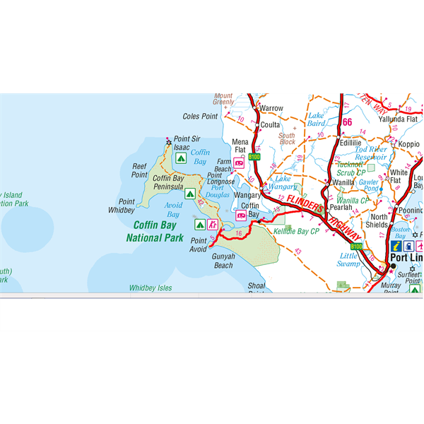
Scale of 1:1 Million
Map 2 is the seamless map that is now on the Navigators at a scale of 1:250,000 and depending on what area you are viewing, does lack detail and even roads compared to the Natmap of the same scale.
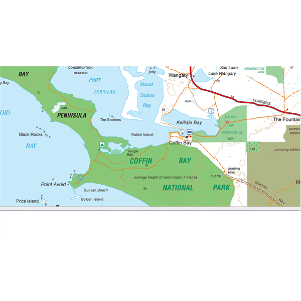
Hema's own 1:250K scale Map
Map 3 is the Natmap 1:250,000 scale that was used on the original HN5, but was zoned , so as to cut down on the file size when opened. The full Natmap seamless 1:250k map of Australia is over 8gb in file size, compared to only 3.71kb of data for Hema's own 1:250k Topo map. So as you can see, you not not have to be a genius to work out that the Natmap and Hema have the same data can not give the same data for a fraction of file size
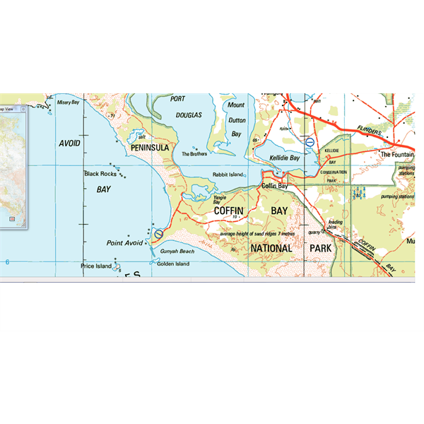
Natmap 1:250k Map
Map 4 shows the greater detail from the 1:50,000 National Parks Map.
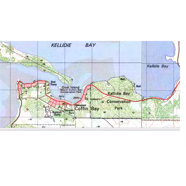
The 1:50k scale map
As for the
Kimberley, the Hema HN5i will be great and for that area, should have all tracks marked that you will be able to travel on.
Cheers
Stephen
AnswerID:
502070
Follow Up By: The Explorer - Wednesday, Jan 09, 2013 at 01:49
Wednesday, Jan 09, 2013 at 01:49
Hello Stephen
At the risk of sounding pedantic regarding terminology.. the term "smaller scale" should be used in reference to the scale of features displayed on a map, not the scale of the map itself. For example, as you have illustrated very
well, a small scale map (e.g. 250K) shows relatively less detail as all features are smaller when compared to a large scale map (e.g. 50K) which shows more detail i.e. features on the map are larger and therefore the map is more "detailed". It is a confusing terminology ...but them's the facts.
Cheers
Greg
| I sent one final shout after him to stick to the track, to which he replied “All right,” That was the last ever seen of Gibson - E Giles 23 April 1874 Lifetime Member
My Profile My Blog Send Message
Moderator |
FollowupID:
778435
Follow Up By: Member - Stephen L (Clare SA) - Wednesday, Jan 09, 2013 at 07:47
Wednesday, Jan 09, 2013 at 07:47
Hi Greg
Thanks for that and correcting my for my error. I need to give accurate information, so now I know better and as you say, facts are facts.
Cheers
Stephen
FollowupID:
778443
Follow Up By: Weavey72 - Wednesday, Jan 09, 2013 at 09:31
Wednesday, Jan 09, 2013 at 09:31
Greg/Stephen,
Thanks to both of you for your information, I think I need to play a bit more to work out how to get the most out of the Hema but one thing I am pretty sure of is it needs to be used in conjunction with a paper map.
Cheers, Lloyd
FollowupID:
778451
Follow Up By: Hema Maps Pty Ltd - Tuesday, Jan 29, 2013 at 10:38
Tuesday, Jan 29, 2013 at 10:38
Lloyd,
Best of luck with learning the ins and outs of your navigator. If you are looking for tutorials feel free to jump on to the
Hema Youtube Chanel
As for your trip, the Hema Kimberly map is one of the best for the area, and if you have the Paper map the map in the Navigator will show you the same information which allows for easy interpretation.
Stephan,
That is a great summery of the maps and their capabilities, I will however mention that 3.7kb will be the .map file (GPS referencing file) the actual size of the Hema 1:250K is around 1.2GB. Also the Map data will be pretty much the same as it is based off the same data, just with some tweaks.
Safe Journey...
Hema
FollowupID:
780276