Down the Oakover to Rudall River (Via Pearana, Hodgson, Christie Xing)
Submitted: Saturday, Apr 13, 2013 at 16:15
ThreadID:
101677
Views:
3748
Replies:
1
FollowUps:
2
This Thread has been Archived
Macca
Hi
I've just watched Mick O's great video of this trip.
I was wondering if Mick - or any others that have undertaken this trip - would advise it better (by way of scenery/pools/ease of travel etc) to take the road to
Marble Bar [I'm coming from Port Headland] then on to
Nullagine-Eel Pool -Woodie Woodie
mine and on...or... take the Ripon Hills Road to the turn off to the Woodie Woodie
Mine and on.
Also - in general terms and assuming just average weather in the season before we start - would a good off road C/T be OK for the journey?? We'll be travelling this route in about July.
Many thanks
George
Reply By: Mick O - Sunday, Apr 14, 2013 at 16:58
Sunday, Apr 14, 2013 at 16:58
George,
The road east from
Nullagine to Eel Pool and on is called the Skull Springs Road and it is usually in fairly good nick being a major hall Road to Woodie Woodie. No dramas with a van but having said that, it would be easier and quicker (and you'd have the comfort of a good bitumen surface) to head down the Ripon Hills Road to Woodie Woodie and then turn right onto the Skull Springs Road at the Woodie Woodie airport. It's only a short trip through to Eel Pool and you would also be able to take in Carrawine Gorge on the way.
There has been a lot of geo field work undertaken in the Oakover as Woodie Woodie looks to expand its manganese operation. As a result, a lot of work has been done on the roads around the area and they have been repaired once the wet is over to facilitate movement of machinery around the area. You would have no issue getting the car and van down to
Christie Crossing area. I have not travelled south of Christies since 2007 but when last through to Balfour Downs and the Talawana. The tracks were
well graded roads. It was a little confusing at times but we ended up at the
Homestead and headed on through to the Talawana OK.
Again a lot of this will depend on the conditions this year and as they are still likely to receive rains until May or later, the conditions of the road may vary.
There was some good
camping spots to be had on the
Nullagine River about half way down the Ripon Hills Road. I’ve heard quite a few rumours of Barra in the
creek but not being much of a fisherman, they remain tall tales only ;-). I do love the drive down the Ripon Hills Road.
Eel Pool is magnificent but be aware that you will not be able to drag the van all the way in. The last 500 metres is pretty rough, a few deep holes and it twists and turns through the paperbark. Most vans have to stay by the greater rivers edge about 400 metres from the actual pools. A beautiful spot none the less.
The access to Rudall from
Christie crossing via
Bocrabee Hill is not suitable for a van.
Mate did you watch the long 10 minute version without music? I’d updated that video and embedded it in the blog of the days travels which goes someway to explaining what was along the way. Other blog links are for repeat journeys into the area and our stop at Pearana for a few days as
well.
Down the Oakover (blog to the video above)The oakover to Pearana Pool 2010Pearana Pool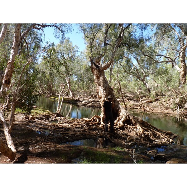
Eel Pool on the Oakover River
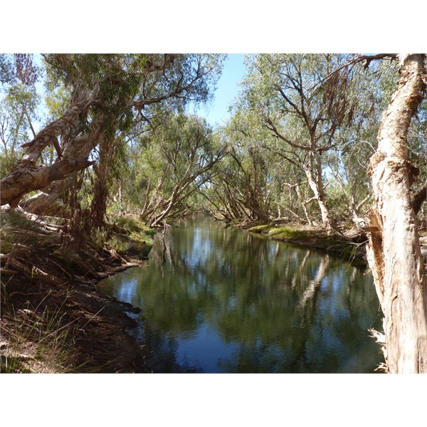
Eel Pool on the Oakover
Cheers Mick
AnswerID:
509008
Follow Up By: Macca - Monday, Apr 15, 2013 at 10:05
Monday, Apr 15, 2013 at 10:05
G'day Mick
Thank you very much for taking the time to reply. Yes - I have watched all the videos you posted but I'll watch the new version as you suggest.
I'll go via Ripon Hills Road.
Just to clarify - the reason for the journey is to enter Rudall NP (using its old name) via Christies Xing and Bocrabee Hils and then on to
Alice Springs via CSR and
Gary Junction Road.
Our camper trailer is a Cub off road Supamatic Regal. You don't consider that the Christies Xing-Bocrabee hills route into the
park is suitable for such a rig? I did noticed the rocks in the track in your video.
We've travelled from Cocklebiddy to Rawlina with it in tow and - although not comfortable - it handled that easily.
Once again , many thanks for you informative reply
George
FollowupID:
786709
Follow Up By: Mick O - Monday, Apr 15, 2013 at 14:57
Monday, Apr 15, 2013 at 14:57
My pleasure George. Sorry mate I took it that you had an offroad van as opposed to a trailer. Look that puts a different complexion on things and I'd suggest you would be OK but there are a few difficult areas that you will need to be aware of. East of Bocrabee there is a soil plain area across which
water sheets readily. This will often remove the vehicle tracks year by year so it can be a little difficult to locate the track. You then have to negotiate a thicket of acacia that brings you onto a grassy plain. The track used to skirt this and go through a
creek. No more as the
creek has sheer walls of 4 metres height. I can give you a few GPS marks for the track on the grass plain so if you get to this point, it’s just a matter of making your own way for a couple of kilometres to this point and you’ll pick up the track again to continue on to Tchukadine Pool.
Second, about 7 km south-west of
hanging rock, the
creek crossing there gets pretty washed out each year for the same reason. It can take a little bit of effort to locate the track on the other side and some careful sand driving to negotiate it.
Are you travelling solo? Are you using a Nav system like Ozi or trackranger or even a Garmin GPS. If so I may be able to dig up a couple of track files from my journeys across that section. Let me know. I’m at mickolsen13@gmail.com.
It’s a short but adventurous drive.
FollowupID:
786727