Comment: Coordinates Converter

The position converter tool is a very useful tool. Is the software available to download onto a computer for use while travelling and pre-trip planning
Back Expand Un-Read 0 Moderator

Reply By: Member - Paul B (WA) - Thursday, Jun 06, 2013 at 22:35

Thursday, Jun 06, 2013 at 22:35
I love them both - position converter and distance calculator and would likewise love them to be downloadable or an App for when I don't have Internet access. I'd even pay for it!
AnswerID: 512678

Follow Up By: Life Member - Phil B (WA) - Thursday, Jun 06, 2013 at 23:33

Thursday, Jun 06, 2013 at 23:33
x 2 on that Paul
There is a lot of difference between
‘Human Being’ and ‘Being Human’.


Lifetime Member
My Profile  My Blog  Send Message

0
FollowupID: 791144

Follow Up By: ExplorOz - David & Michelle - Friday, Jun 07, 2013 at 12:30

Friday, Jun 07, 2013 at 12:30
That is a possibility - what devices do you guys have. Did you know that to develop one for an iPhone is totally different to development for Android - it is such a pain and costly for app delivery. But I will look at doing this - I have learnt Android development with the EOTrackMe app recently (being loaded to Google Play today in fact), so have some understanding of the android side of things.

But let me know what devices you are using?
David
David (DM) & Michelle (MM)
---------------------------------
Always working not enough travelling!

Lifetime Member
My Profile  My Blog  My Position  Send Message
Moderator

0
FollowupID: 791180

Follow Up By: Life Member - Phil B (WA) - Friday, Jun 07, 2013 at 15:29

Friday, Jun 07, 2013 at 15:29
Hi David

Not sure if I'm asking a difficult question here but I was hoping for it as an Excel spreadsheet. Grizzle gives a link below but it doesn't give me Excel.

cheers
There is a lot of difference between
‘Human Being’ and ‘Being Human’.


Lifetime Member
My Profile  My Blog  Send Message

0
FollowupID: 791206

Follow Up By: Member - IH8TRMAC - Friday, Jun 07, 2013 at 20:12

Friday, Jun 07, 2013 at 20:12
X3 I would love a version I can use when out on a trip. Don't always have internet access. I use Oziexplorer on a laptop so would be interested in a software program for that if available. Have not been able to find a good software version as of yet.

Love ya work guys.
Tarmac is another waste of tax payers money!!!!!

Lifetime Member
My Profile  My Position  Send Message

0
FollowupID: 791254

Follow Up By: The Explorer - Friday, Jun 07, 2013 at 22:13

Friday, Jun 07, 2013 at 22:13
Hi

If you are using OziExplorer (PC) you don't need extra software. There are two ways to measure the straight line distance between two points

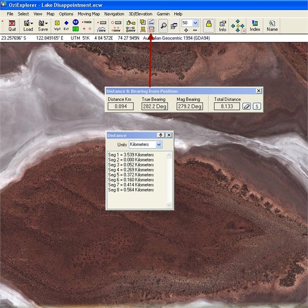
1. Fast way (no need to enter coords) - Open map that contains points of interest . Click on the "show the distance and bearing display" icon - click on the map at the two (or more) points of interest and the distance between them is displayed....you can display units in metric and non metric values (i.e km, metres, feet, yards miles)


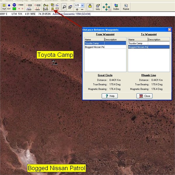
2. Slightly slower way (load waypoint file or click on map to create waypoints and edit coordinates to match what you need if required ....any coordinate system (UTM or Lat/long), any datum). Click on the "show distance between waypoint window" icon and select the two waypoints you would like to determine the distance between - BINGO!


Cheers
Greg


I sent one final shout after him to stick to the track, to which he replied “All right,” That was the last ever seen of Gibson - E Giles 23 April 1874

Lifetime Member
My Profile  My Blog  Send Message
Moderator

1
FollowupID: 791269

Follow Up By: Member - Paul B (WA) - Saturday, Jun 08, 2013 at 08:24

Saturday, Jun 08, 2013 at 08:24
To answer David's question, I currently use an iPhone and iPad although they both frustrate the hell out of me for a range of Apple reasons. I'm due for a new phone which will be Android and I will also get a tablet of some description that runs Ozi, because I've never found anything available in IOs that comes close (sorry Muddmaps).

So short answer, Android for me.
0
FollowupID: 791284

Follow Up By: Member - IH8TRMAC - Sunday, Jun 09, 2013 at 13:52

Sunday, Jun 09, 2013 at 13:52
Thanks Greg but I meant the Coordinates Converter as I understand how to use Ozi's distance functions. I have found that many different books and websites use different formats and I use UTM on my oziexplorer. I find it the easiest to understand.

I try and plan everything before I go on trips but sometimes you miss things.

Regards

Chris

Tarmac is another waste of tax payers money!!!!!

Lifetime Member
My Profile  My Position  Send Message

0
FollowupID: 791371

Follow Up By: equinox - Sunday, Jun 09, 2013 at 14:28

Sunday, Jun 09, 2013 at 14:28
Hi Chris,
You can do it in Ozi.

Randomly drop a waypoint then open up its properties then edit position.
Select either UTM or Degrees & minutes.
Type in the coords in the format you know. Click save then click on properties again.
The other format will be then displayed with the converted figures.
Then delete waypoint (may have to select from waypoint list if not on screen)
Cheers
Alan

Looking for adventure.
In whatever comes our way.


Lifetime Member
My Profile  My Blog  My Position  Send Message

0
FollowupID: 791373

Follow Up By: The Explorer - Sunday, Jun 09, 2013 at 16:01

Sunday, Jun 09, 2013 at 16:01
Sorry IH8TRMAC, wasn't specifically replying to you...but anyway as Alan points out (and what I alluded to)..if you use OziExplorer you are probably unlikely to need any additional coord conversion/distance measuring tools. You can enter waypoint data in any coordinate format and any datum and measure distances between any two waypoints - It does it all and more.

Obviously if you don't have Ozi then the tools provided by David are an excellent start...though typing in more than a few coords can get laborious.

Cheers
Greg
I sent one final shout after him to stick to the track, to which he replied “All right,” That was the last ever seen of Gibson - E Giles 23 April 1874

Lifetime Member
My Profile  My Blog  Send Message
Moderator

0
FollowupID: 791377

Follow Up By: SCUBADOO - Sunday, Jun 09, 2013 at 16:35

Sunday, Jun 09, 2013 at 16:35
OT now I guess.
A little known trick for the OziExplorer users here.

Right mouse click any of the three position data fields at the bottom of this partial screenshot.


0
FollowupID: 791380

Follow Up By: ExplorOz Team - Michelle - Monday, Jun 10, 2013 at 11:33

Monday, Jun 10, 2013 at 11:33
Paul, IH8TRMAC (Chris), and others,
David & I are a little puzzled by your apparent requirements for this tool in an offline situation. As Chris says, coordinate conversion is something you're more likely to do in your trip planning stages. But the page also works from the mobile site so just wondering why the interest in this as an app when you can just visit the webpage from any device from anywhere? The scenario for needing it offline is not that likely surely? And if it is, then you can use the Ozi tools as shown by Greg.
Sorry to challenge you on this, we are very interested in hearing the suggestions for new ideas, but we have to be sure that any new services are going to be viable.
Michelle Martin
Marketing & Customer Support
I.T. Beyond Pty Ltd / ExplorOz

Lifetime Member
My Profile  My Blog  My Position  Send Message
Moderator

0
FollowupID: 791438

Follow Up By: Member - Paul B (WA) - Monday, Jun 10, 2013 at 14:09

Monday, Jun 10, 2013 at 14:09
"... just visit the website from any device from anywhere?"!!

"Assuming you have internet access", I presume is what you meant to add, Michelle.

You may need to get away from it ALL (ie including the internet) a bit more often, Michelle :)

Cheers
0
FollowupID: 791452

Follow Up By: The Explorer - Monday, Jun 10, 2013 at 14:45

Monday, Jun 10, 2013 at 14:45
...I think Michelle meant "from any device from anywhere" while at home, during trip planning - not when out and about as indicated by other comments in her post. But I was never any good at English comprehension so could be wrong.

Cheers
Greg
I sent one final shout after him to stick to the track, to which he replied “All right,” That was the last ever seen of Gibson - E Giles 23 April 1874

Lifetime Member
My Profile  My Blog  Send Message
Moderator

0
FollowupID: 791454

Follow Up By: Member - Paul B (WA) - Monday, Jun 10, 2013 at 15:59

Monday, Jun 10, 2013 at 15:59
Actually, notwithstanding my smart-arsed dig at Michelle, it is a good point she raises. If I switch to Android all my problems are solved because Ozi will work. So as they say in the Army, as you were.

But good thread all the same.

Ta
0
FollowupID: 791459

Follow Up By: The Explorer - Monday, Jun 10, 2013 at 16:25

Monday, Jun 10, 2013 at 16:25
...to a certain extent. The Android version of Ozi doesn't have the same distance measuring and distance between waypoint functions as the PC version...it does however have distance from current position to waypoint so that may provide a solution in some circumstances.

Another useful distance measuring tool in Ozi PC is the track function (i.e. manually make track points - good for determining distance along tracks/roads/routes that are not straight) - also not possible with Android version ..just yet.

Cheers
Greg
I sent one final shout after him to stick to the track, to which he replied “All right,” That was the last ever seen of Gibson - E Giles 23 April 1874

Lifetime Member
My Profile  My Blog  Send Message
Moderator

0
FollowupID: 791462

Reply By: Grizzle - Friday, Jun 07, 2013 at 06:23

Friday, Jun 07, 2013 at 06:23
I put a very basic coordinates converter in the file swap directory a few years ago, I have checked and it is still there. It is an axcel spreadsheet. Might help.

Lifetime Member
My Profile  Send Message

AnswerID: 512689

Reply By: ExplorOz - David & Michelle - Friday, Jun 07, 2013 at 12:34

Friday, Jun 07, 2013 at 12:34
Cherokeejohn,
It does work on the mobile device using the mobile site - see them in action at:

http://m.exploroz.com/Tools/PositionConvert.aspx
http://m.exploroz.com/Tools/DistanceCalc.aspx

I am working on two methods to bring EO content and tools off-line via the mobile system. I am also able to deliver some apps for some functions and this is being worked on in parallel.
David
David (DM) & Michelle (MM)
---------------------------------
Always working not enough travelling!

Lifetime Member
My Profile  My Blog  My Position  Send Message
Moderator

AnswerID: 512726

Reply By: jimbo131 - Friday, Jun 07, 2013 at 22:08

Friday, Jun 07, 2013 at 22:08
I did build an Excel spreadsheet for trip planning using routes established by OziExplorer.

I'll hunt that out, tidy it up and see how I can share it around.

JB
AnswerID: 512758

Follow Up By: jimbo131 - Saturday, Jun 08, 2013 at 15:26

Saturday, Jun 08, 2013 at 15:26
Whoops I can't insert my spreadsheets as I'm not fully financial member

Shame!
0
FollowupID: 791302

Sponsored Links