Well we (Robin & Anne) along with
Howard (ACT) crossed a big one off the bucket list this year.
Over the past few years I have driven a rectangle of tracks around the Northern Simpson by doing the
Hay River to the east, French line to the south.
The Madigan to the north and the Colson track to the west and it was time to nail the dead centre and get to one of the most remote
places I know of, the Geographic centre of the
Simpson desert.
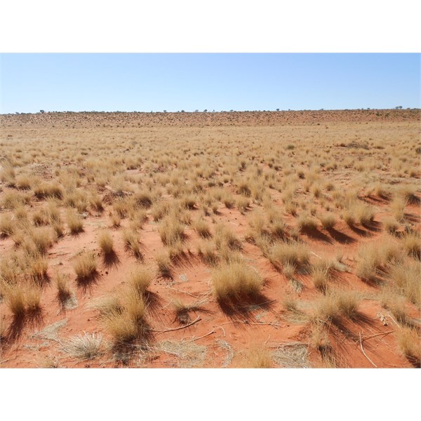
Its a harsh an remote place with very few visitors and as I now know there is very little reason to go there other than the challenge of putting together what it takes to get there and actually doing it.
The research for this trip began many months ago with post 101775 on Exploroz calling for help with information about this challenge.
Several EO's who have been out there responded both on and off line, including Dave JimR Chris(Qld) Stephen L and to all I offer thanks.
Sometimes seemingly little bits of information help form a view and knowledge base that is really helpful when it counts.
In putting together this trip I had different objectives than most.
In addition to just getting there I wished to come up with an approach that would make the journey easy for others in future.
Typically travel to this area has been from west to east taking advantage of the shallower approach to the dunes from the west, intersecting with the Geo Centre then continuing on to the east coming out near Erabena or Poeppels corner.
This is a slow rough approach taking several days with hundreds of dunes to cross, but is easier than approaching the seriously steep stuff from the east.
We like a challenge and in the end
Howard and I came up with a plan which to my knowledge has not been done before.
After much discussion we decided that the easiest way would be to drive straight up the swales between the dunes and return via the same path.
This would minimze the dune crossings and give us an opportunity to make adjustments to the path on the return journey.
The Geo Centre is 80km line of sight at a bearing of 342 degrees from a straight line intersect with the french line.
(In reviewing my research post I note Alan(Equinox) also suggested this approach.)
Several other travellers as far back as Willem Kempon have done part of this route and we even found a reference in the "North Simpson" outback travellers guide handbook (available from EO).
This appears to show that Ian Stabler from Mt Dare went that way before his death in 2007 ?
He apparently did not go all the way and a note in the booklet on page 8 when about 40km from the center says "Track Abandoned - Progress slow and difficult 2-4kmh"
This booklet also mapped the track section north from the french line in S.A. to N.T. but from then on you navigate to waypoints.
About half-way to the centre via this approach is a old
shotline which can be followed to near the Geo Centre which interects with a
shotline coming from Colson track.
I believe this is approach used by Stephen L some years ago.
The
shotline is now almost gone, I couldn't even find it but
Howard and his experienced eye did and we used it.
Shotlines however are just straight line cuts which make a depression which fills up with
water and causes more vegetation and erosion than average along there path.
This means that they get overgrown and can in fact be harder to drive than straight cross country.
This was the case for us however as far as possible we stuck to the
shotline rather than make a new track.
Howard finds the Shotline - can you ?
I had spent many hours plotting an efficent path which, with Howards input became a trip starting at Mungerannie for a 460km drive to the Geo Centre via Warbuton crossing and the K1 line before turning off from the french line.
The return plan was to follow our own tracks back to the french line and then drive straight to
Birdsville for a total of 800km without re-fueling.
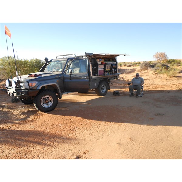
This was a long way in the dirt for my auto petrol 4800 GU Patrol and we both carried around 260lt of fuel.
The Geo Drive
It began easily about noon but soon after we crossed into N.T. we moved from the odd lovely claypan into fields of Moguls, we tried moving up and down the dune slopes but without much relief from the pounding.
Howards computer GPS failed, but he had a secondary system that could only display the underlying map, we put a few waypoints in it manually but I had the only full working navigation system which could track my manually created plot file.
Soon the
water temperature on my Patrol went above what I was comfortable with and we stopped to check all systems.
Just as
well as the rear leaf spring retaining bolt on Howards Landcruiser was almost off with
the nut on by only 1 turn.
I had fitted a 70% shade cloth covering car bra to my vehicle to limit scratches and this along with a warm wind blowing from behind meant the normaly
excellant GU cooling was not enough - I removed the car bra and had no further issue.
I was glad that I had also applied Auto-Goop scratch proofing as additional protection before I left - it was a mess at the trips end.
The day wore on and the sand got softer and soon we were sliding down the steep dune faces which were hard to pick with heavier than normal grass covering the moguls. There was no
sign of any track now for many kilometers and we ploughed along.
I had to constantly watch the GPS bearing, as
well as try to find the best path and I noted that mostly the GPS speed read 13kmh.
Despite the Patrols longer
suspension travel, Howards V8 79 cruiser was doing it easier than my car until I remembered my "Snow Mode" switch.
This remaps and deadends the accelerator and stops you squirting in extra fuel at every moguls bump.
When engaged the car became much smoother to drive.
I left it in "Snow Mode" for the entire trip, but this wasn't enough to stop Anne being tossed around and us all having sore muscles by days end.
The base of my HF aerial went wonky and
Howard had a jar of flour shake loose all over things.
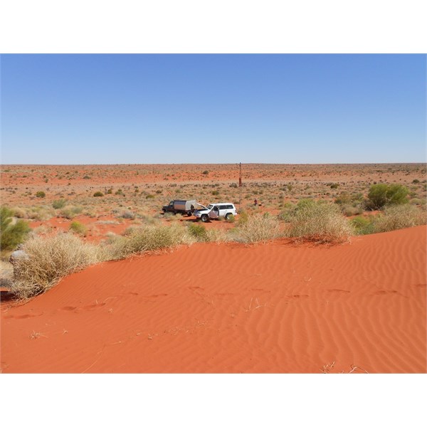
So we camped about 4pm on a flat area just big enough for 2 cars.
It was a long and tiring drive and we needed to adjust a few things but we had made good progress.
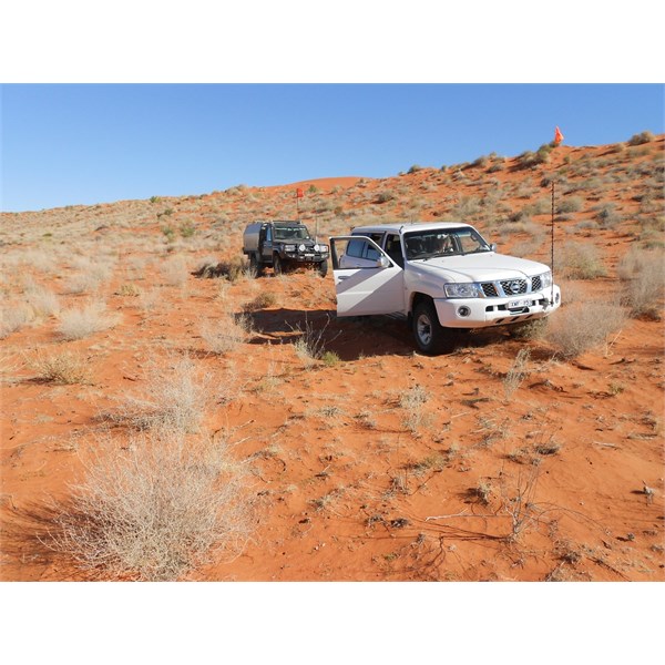
Time to break camp Howard
The next day
Howard picked up the almost impossible to see
shotline line to the centre and took the lead.
The driving was probably even rougher now but navigation was not an issue.
We even saw the occasional faint bike/vehicle tyre marks and the odd
sign of old exploration teams.
Anne found the first of only 3 pickets seen in the 92 km run.
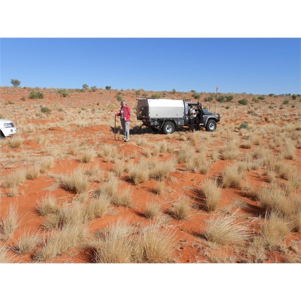
Anne claims finding this star picket
For the last section we followed the advice of others coming out to a point on the old
shotline about 5km east of the centre and then turning west to it.
This however means you have to climb several steep and difficult dunes in the middle of the day.
We had to find alternative paths up and around these but after some hours we arrived at the small tower at the Geo Centre.
Mission objective 1 was now accomplished in about 8 hours of driving for the 92km.
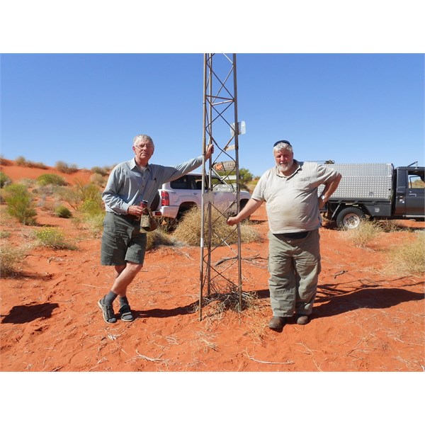
Robin & Howard at the centre
In some ways the drive was easy, we had not come across any rocky bits, or treed bits that couldn't be easily bypassed or any ground
water.
The centre really is an inhospitable place situated just on the western side of a steep dune in mogul country.
We thought about having a rest day but really it was more comfortable in the cars so after 30 minutes, some photo's, and a quick snack we jumped into the cars and were off on the return journey.
The Geo Centre 2013
With
wheels tracks and a now more obvious
shotline to follow we made good progress and by 4pm we were back at the
campsite we used on the way out.
Another perfect night was had - both of us had carried firewood the 2000km up from home and so we didn't even have to go collecting.
Next morning we were off at 7:30 local time for the run back to the highway (our name for the french line).
We had found some steep soft dunes on the way out, but because we were back tracking we knew where the hard parts were and could avoid them by driving round the end of offending dunes.
We completed the return to the french line in 7 driving hours at noon meaning that the entire Geo Centre drive had taken just 48 hours.
We estimate that less than 25 dunes had to be crossed instead of 300 - 500 via other paths.
As a result of our trip we conclude that an overnight return trip from the french line to the Geo Centre is a hard but practical challenge for those fully prepared and experienced in trackless desert conditions.
Cars Fuel Tyres
--------------------
Both cars are
well suited to rough terrain with dual live axles and the ability to sleep internally.
The 2 cars
My 2011 auto petrol 4800 GU Patrol used 25lt/100km or 199lt for the 800km route from Mungerannie to
Birdsville and 32lt/100km for the 184km Geo Centre leg at an average speed of 12kmh.
I do not have accurate figures for Howards V8 79 series tray but we concluded together that in the full desert the Patrol used 40% more fuel but that when cruising at around 120kmh the Patrol actually used less fuel.
I used standard size 32" Cooper ST-Maxx (10ply) at 18psi and the heavy Cruiser ran 33" Mickey MTR in 8/10ply at approx 25psi.
We had no tyre issues at all and there seemed to be less stakes than expected.
P.S. I have made a few assumptions in the above and would welcome any feedback that would make this a more accurate post.
Please refer also to post 101775 which has lots of input from other EO members