Wednesday, Sep 25, 2013 at 14:27
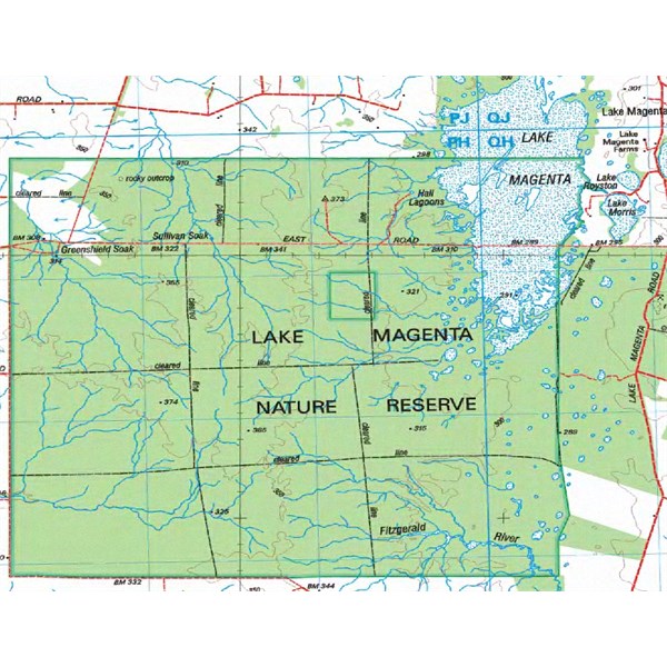
Damien - Google Maps is your friend. Pull up Lake Magenta on Google Maps and examine the sateliite version closely. You'll find that Lake Magenta is not really a huge lake as indicated on some maps, and as shown on the "Maps" version of Google Maps - rather, it's a very large, low-lying area of interconnected small salt lakes, saltbush and samphire.
In wet seasons, some of the smaller lakes fill with a modest amount of
water, up to around 1.5-1.6M deep. The whole lake area becomes treacherous to drive around.
There are local access roads to farmland that skirt the major lake area - and a number of tracks that lead into some of the larger salt lakes, which the locals often use for ski lakes if there's enough
water depth (you only need 1.2M of
water to ski in!).
You'll find there's a local road - East Road, (more of a track, actually) that crosses the lower part of Lake Magenta (in an East-West alignment) which meets up with
the Lake Magenta Rd on the East side of
the Lake.
This local road is just a local access road - and the section across
the Lake is likely to be a "seasonal" road only - and likely to be only good for use in Summer.
You could find yourself in serious de-bogging mode, if you attempted to drive across this section in Winter and Spring.
In addition, it's possible that this part of East Road - despite being originally surveyed as a public road - could now be closed and fenced off.
It's not unusual for local farmers to apply for road closure on little-used roads, and when the application is granted, the road reserve becomes part of their farm, and they fence it, or put a
gate across the road.
However, the track may stay there and still be used by local farmers. If the road has a
gate across it at some point, you can be assured the section has been officially closed and it's now private property.
Before venturing across
the Lake, enquire at any farmhouse you find on East Rd as to whether the section of East Rd across
the Lake is open to the public - and is it currently crossable in a 4WD.
AnswerID:
518723
Follow Up By: The Explorer - Saturday, Sep 28, 2013 at 15:51
Saturday, Sep 28, 2013 at 15:51
Hi
Lake Magenta, west of the point East Road intersects
the lake's eastern
boundary (see 250K raster) is a
Nature Reserve. I doubt the local farmers control access..more likely DPaW (formerly DEC), but I can't confirm this conclusion. I also doubt any section of the road is "private property". Like you I am basing this on information gleaned from maps so no first hand experience.
Lake Magenta
Cheers
Greg
| I sent one final shout after him to stick to the track, to which he replied “All right,” That was the last ever seen of Gibson - E Giles 23 April 1874 Lifetime Member
My Profile My Blog Send Message
Moderator |
FollowupID:
798792