Saturday, Jan 04, 2014 at 00:38
Hi
From A Prospectors Guide to Metal Detecting in WA By D.W. de Havelland (1985).
Page 41-43
BROCKMANS & GOLDEN CROWN
Some 12.2km along the Duncan Highway past
old Halls Creek townsite, lies the start of what is known as Brockmans. A little further on, and on the right hand side of the road, are the remains of an old hut. During the heyday of the area many small vegetable patches lined the
creek banks, providing welcome relief to the 'greens' - starved prospectors.
It is believed that the first major gold discovery of the Kimberleys was made at Brockmans, but the exact location of the gully is not recorded.
What is certainly known is that the first white child born in the
Halls Creek area was a Coleman and the mother gave birth to the girl at Brockmans. The father acted as midwife with a relay of miners on horseback riding to and from the township's telegraph office with progressive reports and instructions from the doctor (on the other end) at
Derby. It was the mother who later laid the foundation stone of the Mechanics Institute.
From the 12.2km mark, dry blowings can be found on both sides of the road. The eastern side contains both the greater concentration of workings and nuggets found.
According to one source a large nugget was located near a gum tree just past the
old car body on the left hand side of the road. This area has since seen the use of a bulldozer so the exact spot can no longer be located. There are still nuggets to be found in the locality.
Many smaller nuggets have been both specked and detected along the roadway, especially after rain. Almost opposite, but slightly south of the Brockmans
ruins, lies an enclosed grave with a rock headstone, the final resting place of a wandering digger.
In a little under a week we detected nearly four ounces of gold within 30 metres of the main road starting near the first
old car body, down to just past Brockmans
ruins.
Still within the Brockmans area lie several important mines and alluvial patches. As N. R. Smith the government geologist reported in 1898, it was considered to be the richest and most widely spread alluvial field on the
Kimberley goldfield.
The 'Golden Crown'
mine , situated almost in the centre of the Brockmans area , was the most productive . Whilst Butcher and partner operated the
mine it returned 1.281.20 ounces of gold from the crushing of 1,153.50 tonnes of ore (prior to 1897). On the 24 January 1888 they sold the
mine and equipment to C. E. Nicholas & Co. for the princely sum of 5,300 pounds cash and 25 .000 pounds worth of script in the newly formed company.
Other mines in the vicinity are the Mt Bradley , which returned 810 ounces from 789 tonnes of ore, Faugh-a-Ballagh, 15.98 ounces for 15 tonnes, and the Lady Margaret. 252 ounces for only 97 tonnes.
Almost every
creek, gully and Oat in the Brockmans area on the eastern side of the road has produced nuggets. In late 1983 a local took me to a bulldozed heap very near the dam marked on the map and picked up several pieces in less than five minutes. It was not unusual to locate a small leader every week or so with many ounces of gold lying close by.
'Rosie's Flat' has very little dry blowing on it, yet the area being almost4km long has produced many many hundreds of nuggets and specimens. The sides of the hills still have pockets of gold untapped by either the old timers or the modern day prospector.
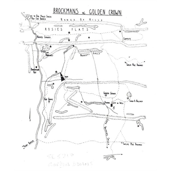
Prospectors Guide - Brockmans Map
Here is approximate location shown on 250K
250K
Cheers
Greg
| I sent one final shout after him to stick to the track, to which he replied “All right,” That was the last ever seen of Gibson - E Giles 23 April 1874 Lifetime Member
My Profile My Blog Send Message
Moderator |
AnswerID:
523851
Follow Up By: equinox - Saturday, Jan 04, 2014 at 01:08
Saturday, Jan 04, 2014 at 01:08
Hi Greg,
Cheers for the info.
What a most interesting, yet most annoying map.
That may be a north arrow on the left, if so the main range is marked incorrect - and the Duncan doesn't seem to match the main track.
I'm guessing the star in the bottom right may be
Flora Valley. The Good Dredging
Creek may be Johnston River.
Any chance you have a 120 year old map of the area? With a
4 Mile Creek marked southish of the hut and a track to
Flora Valley?
I always thought the old track to Flora ran down the Elvire, it appears it may go around the western side of the range.
Thanks again.
Alan
FollowupID:
805414
Follow Up By: The Explorer - Saturday, Jan 04, 2014 at 02:20
Saturday, Jan 04, 2014 at 02:20
Hi
The map does have its limitations - don't think it was ever intended as a super accurate representation of whats on the ground - just hand drawn "guide" so requires interpretation..plus I think you have the scale of the map wrong (i.e. you have the area it covers too large).
Haven't studied it in detail (and as you have found, no scale/co-ords doesn't help), but here is my take on it .....
Wouldn't take the drawing of the "range of hills" as referring to actual large scale ranges, just some small hills i.e north arrow may
well be OK. Think you would have to be onsite to judge the accuracy of this aspect of the map.
The star your refer to (and all the others) is where they found gold - nothing to do with
Flora Valley (yes map should have a legend - by the way ...the shaded areas represent piles of dry blowings left by first prospectors.)
The "Good Dredging Creek" is a very minor tributary of the Black Elvire River. Johnson River (like
Flora Valley) is 17km further east and on the other side of the Edward Range.
Not sure where
4 Mile Creek is ..but as mentioned above,
Flora Valley (the old
homestead) like Johnston River is not even close to being on the map. The map just shows the "Brockmans" mining area (about 5km by 6km plus or minus a KM or two) not a map of the larger area.
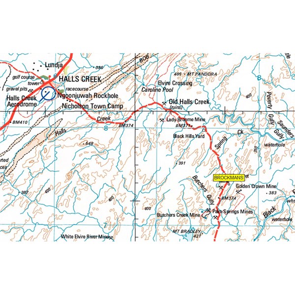
I have attached the 250K map with the approximate area I think the hand drawn map by de Havelland covers (hatched area).
I think if your were actually there on the ground (and doing some prospecting maybe) you would find the map handy - better than nothing. Sorry for confusion.
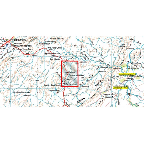
Map Coverage
Cheers
Greg
| I sent one final shout after him to stick to the track, to which he replied “All right,” That was the last ever seen of Gibson - E Giles 23 April 1874 Lifetime Member
My Profile My Blog Send Message
Moderator |
FollowupID:
805415