Sunday History Photo / NT

Submitted: Sunday, Sep 14, 2014 at 09:05
ThreadID: 109496 Views:5459 Replies:5 FollowUps:8
This Thread has been Archived
All that remains of the former mining town Grove Hill, halfway between Katherine and Darwin, is concrete slabs and the Historic Hotel. Grove Hill is a remote locality in the Victoria Daly Shire, Northern Territory, Australia. Once a centre for mining operations, today only a hotel with a few outbuildings remain at the site. The AdelaideDarwin railway passes through Grove Hill.
Settlement of Grove Hill began after the discovery of gold by prospector Harry Roberts in 1872 during construction of the Overland Telegraph. A stamping battery became operational on 6 June 1887 and was used to crush stone from surrounding mines.


Grove Hill was formerly a siding on the North Australia Railway where a 2 ft gauge steam tramway some 12 miles in length was constructed in 1904 to connect the nearby Mount Ellison and Iron Blow mines met the main line, with a dual gauge section allowing main line wagons to be hauled to the private smelting works.
The Iron Blow mine, located 2 miles south of the siding produced gold until its abandonment in 1914. The area surrounding the mine was surveyed by the Australian Government in 1960 after reports that there remained 33,000 tons of mineral ore available for extraction.
Prior to 1935, a township and miners camp had thrived approximately 2.5 miles south of the railway line. As the gold rush was ending, this settlement was abandoned and a hotel constructed near the railway sidings to take advantage of new business opportunities brought by travelers passing through the area.


The remains of the settlement were further isolated in by the closure of the railway line in 1976 and was bypassed by the Stuart Highway when it was upgraded to National Highway standard between 1970–92, passing 9.3 miles, with the former road alignment now forming part of the Northern Goldfields Loop tourist drive.
The Grove Hill Hotel was built in 1934 from materials scavenged from abandoned mining sites in the aftermath of the Great Depression. It has remained operating as a licenced hotel since and also incorporates a heritage museum with displaying historical artifacts from the local area. The hotel is renowned for birdwatching nearby. It was listed for sale by auction on 12 July 2012 with a reserve price of $760,000, attracting widespread media coverage.


.
gift by Daughter

Lifetime Member
My Profile  My Blog  Send Message

Back Expand Un-Read 14 Moderator

Reply By: Member - Alan H (QLD) - Sunday, Sep 14, 2014 at 13:15

Sunday, Sep 14, 2014 at 13:15
Thanks Doug.

Interesting area just off the main hwy.

Alan
AnswerID: 539067

Reply By: Ron N - Sunday, Sep 14, 2014 at 18:02

Sunday, Sep 14, 2014 at 18:02
Thanks Doug, another little place I never knew existed.

Can you tell me anything about this unmarked town, a little further down the line?
It's all surveyed and planned around the siding, it appears - but it looks like it never even got off the ground.
Either that, it was a town once and everyone cleared out and stripped the place and left nothing, kind of like Kanowna.

Unmarked town

Cheers, Ron.
AnswerID: 539074

Follow Up By: Life Member-Doug T NSW - Sunday, Sep 14, 2014 at 20:58

Sunday, Sep 14, 2014 at 20:58
I don't see any surveyed area at the location you gave, but it could have been the Original site..

( Prior to 1935, a township and miners camp had thrived approximately 2.5 miles south of the railway line.)

.
gift by Daughter

Lifetime Member
My Profile  My Blog  Send Message

0
FollowupID: 823686

Follow Up By: Ron N - Sunday, Sep 14, 2014 at 21:33

Sunday, Sep 14, 2014 at 21:33
O.K. - here's a screenshot of what I see at that spot on Google Maps.

Un-named town

At the top left of the town survey area there appears to be a railway dam? (on Earth View or Satellite View).
0
FollowupID: 823691

Follow Up By: Life Member-Doug T NSW - Monday, Sep 15, 2014 at 02:57

Monday, Sep 15, 2014 at 02:57
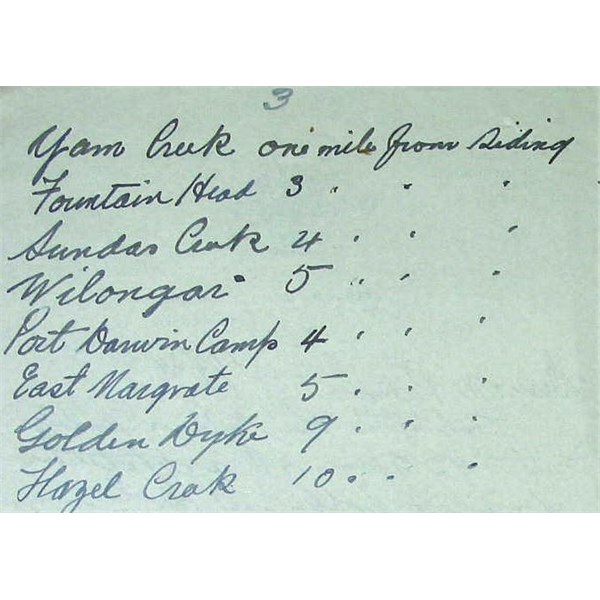
It's hard to say what that is Ron, It could be any one of the names in the photo I have posted here or it could be Brocks Creek.


Brock's Creek was the first area in which gold was discovered in the Northern Territory. It was discovered by William Brock a Government Assistant Inspector of Works with the Darwent and Dalwood Overland Telegraph Construction team in 1870. Brock's Creek Township was officially gazetted on 5 May 1898 and was named in honour of William Brock. By 1886 Brock's Creek had the largest Chinese population in the Northern Territory which at one time it was reported reached 400 people. The township and railway siding is important as a former centre of population on the NT goldfields and an important military supply base and detention centre during World War II. Brock's Creek growth in importance was centred around the local mining industry which developed in the area. Some of the first mining leases were taken out by Europeans but were soon transferred to Chinese interests by 1889. The area is also notable for the infamous mining companies operating in the Northern Territory at the time and who had vast interests in the area. A majority of these companies were originally registered in London, England. It is also notable for the investment by local syndicates and finally for the takeover of one of the major mines in the area, Zapopan, by the Commonwealth Government in 1910. The site is of high social significance as a former commercial and meeting centre for the district. Brock's Creek Railway Siding was specifically established to cater for and serve the interests of the mining companies and residents in the area. This was because the location of the original railway siding at Fountain Head was ill conceived and inconvenient subsequently costing the mining companies valuable money, time and resources. The Railway Siding served as a transport link to the pastoralists in the area. Vesteys who had large holdings in the area used the railway to transport cattle to Darwin for their live export business to the Philippines. The growth of Brock's Creek was due mainly to the commercial and economic potential and success of the immediate area. The township had a number of interesting and famous residents associated with it including Thomas George Crush who was the proprietor of the Federation Hotel and later the member for the Northern Territory in the South Australian Parliament. The hotel was the hub of "posh" society and was regularly visited by members of "Darwin Society" and many social events were held there and at the Mine Managers Residence. His wife Fanny Haynes is well known in the Northern Territory as the proprietor of the Federation Hotel after her husband's death. The site is of high historic and social value. The townsite consists of the four original blocks auctioned in 1898 on which the foundations of the original store and Federation Hotel remain. The railway siding consists of the railway line, loading ramp, shunting area and the toilet dating from pre World War II. Brocks Creek Military Detention Barracks was constructed in early 1942 utilising the existing Police buildings and the slabs of the earlier school buildings. It was popularly known as "Belsen" to the soldiers and civilians at the time. It is a reminder of the disciplinary measures employed by the Australian defence forces during World War II and is the only surviving example of this form of military installation in the Katherine-Darwin region and the Northern Territory. The site is also significant culturally and socially through its association with Government Administration Policy of the time by the continuous Police presence on the site from 1898-1953 and the establishment of schools from 1906-1917. The site contains the fabric of the former Police Structures dating from the 1890s as well as that of the two school buildings dating from 1906 and the Detention Barracks from World War II.
Description: Brocks Creek Township: The site contains a range of features including the remains of the Federation Hotel consisting of the concrete floor surfaces and a collapsed well; a raised earth surface within concrete abutments representing the fuel drum filling shed platform; foundations of the fuel storage tanks; remains of military quarters and mess room foundations consisting of concrete slabs; remains of the military power house site consisting of a concrete slab; an arrangement of earth filled 44 gallon drums and large sand dump said to have been the waste dump of a ballast crusher. Railway Siding: This group of sites covers an area about 500m x 120m and consists of an earth platform, railway latrine, main line and siding loop, and remains of military BIPOD siding and F.S.D. spur line sites. Military Detention Barracks: The site covers an area about 250m x 300m and contains a number of structural sites and relics situated on the former police and hospital reserves. The remains of the earlier police site comprise a number of structural floor surfaces of varying composition, pathways and rock-edged garden plots. The earlier police station is thought to have occupied the southern-most and most substantial of these floor surfaces which comprises carefully selected flagstones set in concrete, concrete and bitumen over concrete. On the eastern side a pathway of broken concrete slabs leads to a former structural site, possibly a cell
---

gift by Daughter

Lifetime Member
My Profile  My Blog  Send Message

1
FollowupID: 823701

Follow Up By: Ron N - Monday, Sep 15, 2014 at 08:52

Monday, Sep 15, 2014 at 08:52
That's a great piece of info and research, thanks! It's just amazing the history of some of these old places - particularly the mining towns, where huge plans were laid, a lot of buildings constructed, and a lot of activity took place - but where the place rapidly ran down, and virtually nothing remains.
1
FollowupID: 823707

Follow Up By: Rob B16 - Wednesday, Sep 17, 2014 at 12:35

Wednesday, Sep 17, 2014 at 12:35
That's my local! Thanks for putting it up Doug.
Ron, township you are looking at is Burrundie. Was a thriving town at one stage. Land sales started in 1885 and it is still a gazetted town with a few blocks still held in freehold waiting for heirs that don't know they exist. The streets and blocks that you see on the map do not exist on the ground but pass through with a GPS and it shows up on the device. You're right, that is a railway dam for refilling the steam trains, hand dug with horses and scoops. There are three wells there filled with crystal clear water, few slabs of concrete and only thing standing is one chimney and the siding. Not far up the rail is two explosive magazines, one underground and one that looks like a chapel. Burrundie cemetery is located a few km's away towards Mt.Wells. The Pine Creek museum was originally the mining wardens home at Burrundie and is the oldest prefab structure in the NT. It was moved in 1913. Some ceremony happening this month on Sat. 27th with Chief Minister opening a plaque at Burrundie. Not sure what it is about, frame is up but no plaque on there yet.
3
FollowupID: 823817

Follow Up By: Ron N - Wednesday, Sep 17, 2014 at 13:16

Wednesday, Sep 17, 2014 at 13:16
Thanks Rob, for the great info! Typical of the old places of the late 1800's and early 1900's that have virtually disappeared without trace.
My SIL has the original survey map of Higginsville townsite in W.A.
Higginsville was planned to be a decent size town, and extended over numerous blocks.
It was established as a town adjacent to the Higginsville siding when the rail line was pushed through to Norseman from Coolgardie in 1907.
However, despite being quite a consistent mining area (gold and scheelite), WW1 saw it lose a large amount of population and it never recovered.
Many buildings were gradually removed from Higginsville after WW1 as the miners never returned to mining after fighting - because the accent after WW1 was on agricultural development.
The Higginsville store lasted until about the early 1950's, I think - when the population became a lot more mobile with the upsurge in new cheap cars such as the Holden, and better roads.
When our family bought the Fairplay Gold mine in 1972, the population of Higginsville was about 4 to 6 prospectors and a number of other itinerant prospectors who moved in and out.
Most prospectors lived in humpies and shacks built of scrounged materials.
The Higginsville Hall, a substantial building, was still intact when we arrived in 1972 - but scroungers, "antique" collectors, and vandals gradually demolished it.
Somewhat surprisingly, the W.A. Govt has totally removed the Higginsville townsite survey from existence - thus the reason SIL got the original map.
2
FollowupID: 823818

Follow Up By: Life Member-Doug T NSW - Wednesday, Sep 17, 2014 at 21:01

Wednesday, Sep 17, 2014 at 21:01
Thanks you guys for your input, I have some photo's of the Explosive magazine sent to me by Member Noel K from Darwin a few months ago, here are 2 , he also sent a photo of a headstone in a Cemetery, the Chimney mentioned above and some Concrete slabs.


.
gift by Daughter

Lifetime Member
My Profile  My Blog  Send Message

2
FollowupID: 823834

Reply By: Member - Michael John T (VIC) - Sunday, Sep 14, 2014 at 18:23

Sunday, Sep 14, 2014 at 18:23
Thanks Doug,

We stopped there for a beer back in 2010 and found it very interesting, a lot of history locked up in that pub. Also found a couple of abandoned mine sites not so far away as well, at one of them there was a number of old 'Richmond Beer' bottles (Victoria) scattered about.

Its an interesting area and very good of you to remind us about it.

Regards,

Mike.
AnswerID: 539075

Follow Up By: Life Member-Doug T NSW - Monday, Sep 15, 2014 at 02:40

Monday, Sep 15, 2014 at 02:40
There's heaps of those Richmond bottles around Mt Bundy and Adelaide River too.

.
gift by Daughter

Lifetime Member
My Profile  My Blog  Send Message

0
FollowupID: 823699

Reply By: Ron N - Wednesday, Sep 17, 2014 at 16:33

Wednesday, Sep 17, 2014 at 16:33
You can get some interesting snippets and tales of life in these old towns by going to Trove and the digitised newspapers section, and inputting a search using the towns name.
You can search by State, by newspaper, by decade, by year, by month, and even by exact date. You can also pick between articles and advertising.
You can also bring up instant results merely by typing "trove" and the towns name into Google.

I've found some fascinating stories about many old towns and characters in the newspaper archives on Trove.
I've even found records of old vehicles owners when new, or stories about the exploits of vehicles, when someone was restoring one, and wanted to find out more about its history.
In W.A. & S.A. the newspapers published the registration details of every new vehicle sold, from around WW1 up to around the start of WW2.

Unfortunately, because the old newspapers are scanned using optical recognition software, and the print quality being often less than satisfactory - this means that a lot of info can be missed by the search engine.
One can register and re-type articles to read correctly, which assists in fixing the OCR problem, and I often do this if I have time.
AnswerID: 539215

Reply By: Member - Stanley D - Friday, Sep 19, 2014 at 23:20

Friday, Sep 19, 2014 at 23:20
Dear Doug,
I appreciate all the work that you do presenting the information you find. I look forward to your publications and find them very fascinating. I learn so much from you.
Thank you again ,
Regards, Stanley
AnswerID: 539300

Sponsored Links