Source of the Shoalhaven River
Submitted: Sunday, Nov 30, 2014 at 16:20
ThreadID:
110297
Views:
4673
Replies:
4
FollowUps:
7
This Thread has been Archived
Member - John G
G'day Folks
I've been doing a bit of googling on Bungendore and
Braidwood, and have gone down a sidetrack trying to find the source of the Shoalhaven.
Being a simple soul I've followed the thin blue line of the river on NP maps and finished up a wee bit south of the Berlang
camping ground on the
Cooma Road from
Braidwood. There's a spot out there called 'Jinglemoney" - a reference to gold perhaps? I've also come across another article referring to the headwaters of the Shoalhaven being near
Bredbo.
I think I understand the distinction between 'headwaters' and the start of a river, but my question is whether someone may be able to assist with the location of the start of the river itself, and whether it is accessible, either on foot or by vehicle.
I appreciate that this is lazy research. I will continue working on it by accessing better maps.
Cheers
John
Reply By: OBJ - Sunday, Nov 30, 2014 at 16:33
Sunday, Nov 30, 2014 at 16:33
Dr Wikipedia advises:
"The
Shoalhaven River rises on the eastern side of the Great Dividing Range, below Euranbene Mountain, about 350 kilometres (220 mi) southwest of
Sydney. The upper reaches of the river flow northwards through an upland pastoral district near the town of
Braidwood. The river works its way down into a remote canyon east of
Goulburn and emerges into the coastal lowlands at Nowra in the Shoalhaven district, where it is spanned by the historic Nowra Bridge. The river is joined by thirty-four tributaries, including the Mongarlowe, Corang, Endrick, and Kangaroo rivers, and descends 864 metres (2,835 ft) over its 327-kilometre (203 mi) course.".
This may get you started.
OBJ
AnswerID:
542400
Follow Up By: Frank P (NSW) - Sunday, Nov 30, 2014 at 16:59
Sunday, Nov 30, 2014 at 16:59
Here's a 25k screenshot from OziExplorer showing Euranbeen Mt and to the east a stream labelled Shoalhaven. Does that fit a cartographical description of "rising below Euranbene Mt"? Doesn't seem quite right to me.
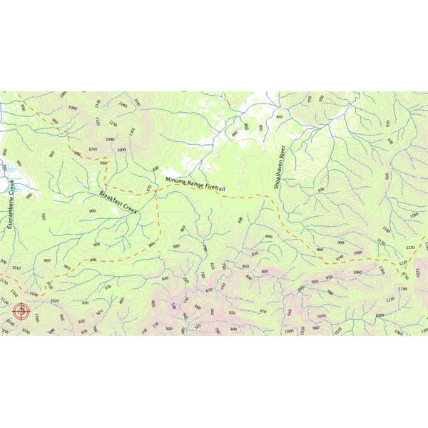
Euranbene-Shoalhaven
Cheers
FollowupID:
828670
Follow Up By: Frank P (NSW) - Sunday, Nov 30, 2014 at 17:00
Sunday, Nov 30, 2014 at 17:00
Sorry, forgot to say Euranbeen Mt is marked by the gunsight.
FollowupID:
828671
Reply By: Frank P (NSW) - Sunday, Nov 30, 2014 at 16:50
Sunday, Nov 30, 2014 at 16:50
G'day John,
Here are a couple of screenshots from OziExplorer. First one is 25K.
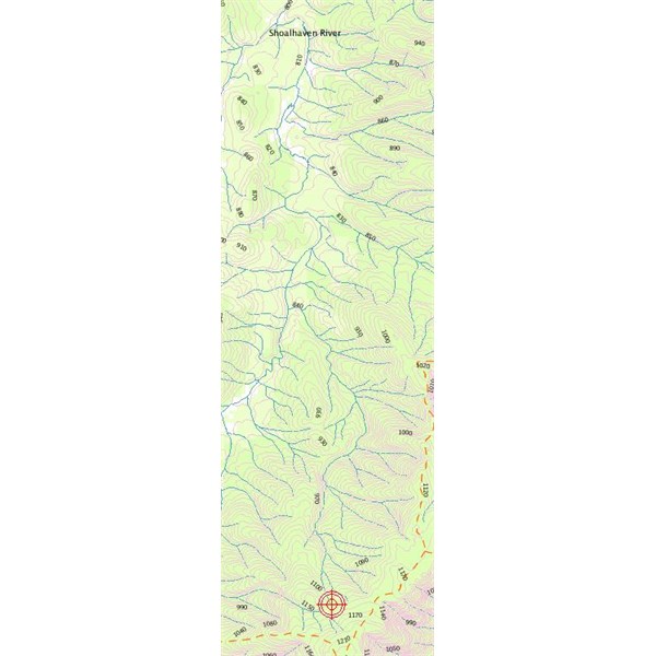
Second one is EO Topo 200k to give you a bigger picture.
On those maps, depending which blue line you follow on the 25k map, it's around 36 deg 56.313min S, 149deg 42.911min E. That makes it pretty close to the Minuma Range Fire Train, not too far from
Bendethera.
8826-Araluen 25K
EO Topo 200k
Cheers
Frank
AnswerID:
542401
Follow Up By: Frank P (NSW) - Sunday, Nov 30, 2014 at 17:05
Sunday, Nov 30, 2014 at 17:05
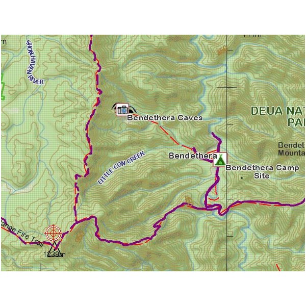
Another apology - knocked the mouse and got the wrong coords above. Try in the area of 35deg 59.056S 149deg 39.811E
FollowupID:
828672
Follow Up By: vk1dx - Monday, Dec 01, 2014 at 18:46
Monday, Dec 01, 2014 at 18:46
I get the same result as Frank. Just off the Minuma Range Fire Trail as shown above, which is the "western" access or exit for
Bendethera camp ground.
FollowupID:
828799
Reply By: Member - Warrie (NSW) - Sunday, Nov 30, 2014 at 21:33
Sunday, Nov 30, 2014 at 21:33
Hi John, we did a trip along the Minima Fire Trail in 2009.It was a fabulous day with an unexpected snowfall. Hit this link to
Dampier Trig Point which by the look of Franks map above is a few hundred metres from the source of the river. As the Minima Fire Trail follows along
the ridge running east - west it means the Shoalhaven source is on the northern side of the trail. But don't expect too much. If it's anything like the source of the Murray it may just be a damp patch in the forest without the
metal pole. Or it could be even less with just a dip in the ground that won't look any different to the rest of the forest.Good luck finding it...... W
AnswerID:
542414
Follow Up By: Member - John G - Monday, Dec 01, 2014 at 10:15
Monday, Dec 01, 2014 at 10:15
Thanks Warrie
I agree re expectations and luck.
I'm no geographer or cartographer, so i'm inclined to the easy-option view that the start of a river must change over time, and that on any day it starts where the ground is damp and there a pools of
water to see. But . . . I do also appreciate history.
How accessible is the fire trail? Serious 4WD, or would an ix35 make it on a good day?
Cheers
John
FollowupID:
828743
Follow Up By: Member - Warrie (NSW) - Tuesday, Dec 02, 2014 at 13:50
Tuesday, Dec 02, 2014 at 13:50
Hi John, just read your post and had to look up details about the i35. Look at pix in
places for
Bendethera and the Minuma Fire Trail to see how muddy the trail was in the rain and snow. In our 4WD R50 Pathfinder no problems so if you have the 4wd i35 one would expect it to handle it. And on a dry track a 2wd with reasonable clearance would cope............... W
FollowupID:
828858
Reply By: Nomadic Navara - Wednesday, Dec 03, 2014 at 18:49
Wednesday, Dec 03, 2014 at 18:49
Bonzle is always a good place to start for things like that.
AnswerID:
542516
Follow Up By: Member - John G - Thursday, Dec 04, 2014 at 11:04
Thursday, Dec 04, 2014 at 11:04
Thanks Peter
I recall we corresponded on the source of the Lachlan. A more easily accessible proposition than the Shoalhaven I think.
Cheers
John
FollowupID:
828934