Treks feature requests
Submitted: Friday, Mar 20, 2015 at 16:33
ThreadID:
117142
Views:
2243
Replies:
3
FollowUps:
2
This Thread has been Archived
Member - Boobook
One of the nuggets of the EO site is the Treks ( and
Places). The experience of David and Michelle and members is really useful in planning trips, especially away from
services.
IMHO if possible some small (LOL) additions would really add value. to the planning process.
1)Just like you can see the altitude profile, a speed profile would be useful ( more useful in the outback). I use the treks of previous users ( Cheers Baz and StephenL, David and Michelle) who seem to have criss-crossed every part of
the desert ( and every bloody Confluence Stephen grrrh). These are great to set a planned pace.
It woudl be great if you could pick a start point and an end point and get an altitude profile, average speed etc for that section. THAT would be unique and things like GPS editor can do it externally.
2)Have to option to view both User treks and EO treks on the same page. They are both useful and the location is the key to how applicable they are, not the source.
Hope this isn't over the top, and I am sure you have tons to do but IMHO EO's greatest strength is as a planning resource. I woudl have thought the more searches done withing EO the more ad traffic( hotels etc)
Anyway just a thought.
Reply By: Member - Boobook - Friday, Mar 20, 2015 at 20:57
Friday, Mar 20, 2015 at 20:57
Oops
It woudl be great if you could pick a start point and an end point and get an altitude profile, average speed etc for that section. THAT would be unique and things like GPS editor can do it externally.
Should read
It would be great if you could pick a start point and an end point and get an SPEED profile, average speed etc for that section. THAT would be unique and things like GPS editor can do it externally.
To clarify it more with an example. I am planning a trip and using a downloaded trek on my Mapping program - in this case Memory Map. When it is loaded into my maps I can see the time of day, and instant speed of that trek by pointing my mouse to the track at any point. I can see when and where the person started for the day, when and where they stopped for the day and the speed they traveled at at any point.
So I now have a good idea of how far to travel on an outback track per day. 105 - 200km.
Wouldn't it be great if I could select parts of that track on EO and get speed profiles and Times wothout downloading the tracks.
I have seen this concept on some exchange rate and share graphs where you can pick the start date and end date as a sliding bar and it gives you detail.
You may get an idea from
this website
Under the graph, on the right side you will see 2 sliders. If you move them left you can control the date end points. Same thing with the treks with the speed ( and also show those end points on the map)
Hope this makes sense
AnswerID:
551293
Reply By: ExplorOz Team - Michelle - Friday, Mar 20, 2015 at 20:57
Friday, Mar 20, 2015 at 20:57
Thank you for your constructive suggestions. We love to hear specific ideas for how you'd like us to improve existing core features. I'm sure what you suggest isn't impossible - the speed data is in the GPS file used to create each trek note and is used to create the timings shown in the "Directions" tab ie. time to travel between each point.
My initial consideration of this however is that there could potentially be a problem or the data could be irrelevant, due to how frequently conditions change, the fact that driver confidence varies, and the type of rig/load you drive will create very different speed profiles for the same section of track so I'm not sure of the real value of the data. Trek notes are based on 1 data source. ... Dave might have more to say on this when he gets a chance to see this post (away now).
Your second point, can actually be done already. Here's a pic to show you the settings to change to have both User Treks and Treks Notes appear at the same time in the map.
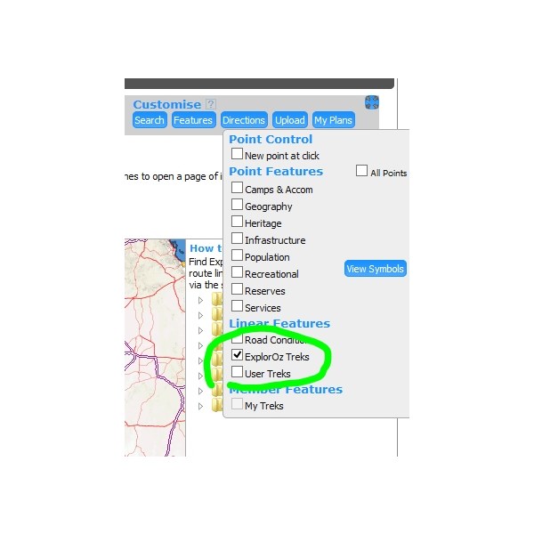
How to change data shown on map
AnswerID:
551294
Follow Up By: ExplorOz Team - Michelle - Friday, Mar 20, 2015 at 21:00
Friday, Mar 20, 2015 at 21:00
To clarify how I got that to appear, I opened any map and click the FEATURES tab and this pull down list of options appears. This is how you can change what is loaded onto a map. You can do this in
Places, and any map shown in Treks. Does this help?
FollowupID:
836776
Follow Up By: Member - Boobook - Friday, Mar 20, 2015 at 23:39
Friday, Mar 20, 2015 at 23:39
LOL I have looked at that page 1000000 times and never seen that.
RTFM
FollowupID:
836791
Reply By: Member - Stephen L (Clare SA) - Friday, Mar 20, 2015 at 21:07
Friday, Mar 20, 2015 at 21:07
Hi Boobook
Don't ask Fiona about Degree Confluences, as she now calls them....ABC......
Another Bloody Confluence.......lol
But having said that, chasing the odd confluence or two has taken us to some great
places than you would never normally think of visiting.
Cheers and happy trip planning.
Stephen
AnswerID:
551296