Kennedy Ranges near Gascoyne Junction
Submitted: Thursday, May 07, 2015 at 09:30
ThreadID:
117756
Views:
5556
Replies:
8
FollowUps:
10
This Thread has been Archived
Craig M1
Hi , I am planning a trip to the Kennedy Ranges this June.
I have heard of a track , I think called the "ridge top track" which at the northern end of the ranges is approached from Mount Sandiman. I have seen it on the Hema Australia Topo 1:250,000 map, not sure if that means it actually exists on the ground.
From the northern end of the range the track works it way up on to the top of the range.
It then travels south along the eastern escarpment for around 20 km. The track then turns west and heads across the ranges and then descends down the western side of the Kennedy Ranges through a river/
creek valley. The track exits at a place called Binthala.
My query is on the condition of this track ,
1) whether it is suitable for a heavy duty camper trailer,
2) which is the best direction to travel , ie north to south or vice versa
3) what are the tracks like from Mount Sandiman to the base of the range , and from Binthala back on to the
Carnarvon / Gascoyne road and the Gascoyne
river crossing.
Thanks Craig
Reply By: Peter_n_Margaret - Thursday, May 07, 2015 at 11:18
Thursday, May 07, 2015 at 11:18
2006.
I suggest...
1. Get in touch wilt National Parks first. They were very helpful.
Carnarvon, from memory.
2. Go up the west side and down the east. Would be easy to get lost amongst the tracks the other way.
A fascinating and surprising place. Not at all what you might expect.
Cheers,
Peter
OKA196 Motorhome
AnswerID:
553414
Follow Up By: rocco2010 - Thursday, May 07, 2015 at 11:36
Thursday, May 07, 2015 at 11:36
Peter
Thanks for the photos. I have heard about the top of the Kennedys but never seen it. The east side itself is a fascinating place.
My info from around a campfire from someone who has been there said access from the West had been stopped by the property owner a few years ago.
Cheers
FollowupID:
839240
Follow Up By: Peter_n_Margaret - Thursday, May 07, 2015 at 12:20
Thursday, May 07, 2015 at 12:20
I don't know the current situation with regard to access from the west, but in 2006, Parks told us that the owner of Mooka was unfriendly, but the road was a public one and we had the right to use it but we should not stray off it.
National Parks owned Bilthatya Station, at that time.
We had permission to transit Mount Sandiman from the owners (who were on another property some distance away....can't recall which one).
Cheers,
Peter
OKA196 Motorhome
FollowupID:
839243
Follow Up By: Craig M1 - Thursday, May 07, 2015 at 14:49
Thursday, May 07, 2015 at 14:49
Hi Peter and Margaret and Rocco thanks for all the photos and information. Certainly looks worth the trip. I will give
Carnarvon parks and wild life a call.
Regards Craig
FollowupID:
839249
Follow Up By: Member - Paul B (WA) - Thursday, May 07, 2015 at 21:44
Thursday, May 07, 2015 at 21:44
Wonderful pics, thanks very much. Another for the bucket list - just going to have to stay around long enough now!
FollowupID:
839269
Reply By: Member - Duncan W (WA) - Thursday, May 07, 2015 at 14:45
Thursday, May 07, 2015 at 14:45
We did it a few years back from the west entered via Mooka Springs and crossed the Gascoyne River. The
river crossing was about 100m wide at the time and about 400mm deep at its deepest. Would walk it if I was you if it has any
water in it.
One of our group was towing a Cub Camper and had no problem at all and another was towing a home made job which "weighed a ton", he snapped a stub axel but that was just due to the weight of it.
When we got to the top and amongst the dunes it was 40 degrees +/- and we had a thunder storm so extremely specky. We then hit the scarp and proceeded down coming out at Mt Sandiman Stn.
A fantastic trip and I think from memory the map is available on the DPaW website.
Cheers
Dunc
AnswerID:
553419
Follow Up By: Craig M1 - Thursday, May 07, 2015 at 16:20
Thursday, May 07, 2015 at 16:20
Thanks Dunc
Seems doable, hopefully it won't be 40c plus in the middle of June.
Carnarvon Dept of Parks and WLife were very helpful. Said the western approach could be a little washed out at the creeks so to take it easy.
Regards Craig
FollowupID:
839253
Follow Up By: Peter_n_Margaret - Thursday, May 07, 2015 at 16:38
Thursday, May 07, 2015 at 16:38
Craig, did they comment on access via Mooka and permissions for the east side?
Cheers,
Peter
OKA196 Motorhome
FollowupID:
839254
Follow Up By: Craig M1 - Thursday, May 07, 2015 at 21:53
Thursday, May 07, 2015 at 21:53
Hi Peter
Carnarvon Dept parks and wildlife said no permission was required to travel the track but suggested a courtesy call to the Bidgemia Station owners ( owner McTaggert) who also own the Mount Sandiman station would be appreciated.
Bidgemia Station is just east of
Gascoyne Junction on the
Carnarvon /
Mullewa road.
There was no mention about Mooka Station.
Regards Craig
FollowupID:
839271
Reply By: Member - John Baas (WA) - Thursday, May 07, 2015 at 22:08
Thursday, May 07, 2015 at 22:08
Hi Craig.
The trip is very do-able. We have twice recently 2011/2014 done it with a full size CUB CT in tow. If approaching from the Sandiman end you'll come across an 'agro' '
track closed'
sign. The
sign refers to a different track.
You'll need to go right past the HS (just off the gravel - they were selling eggs both times - the people are friendly so say hello).
Going west, when you start coming down the slope, just go easy because it's a bit agricultural; nothing that a bit of care won't sort out.
If coming from the west, you'll find DPaW
signage discouraging punters; ignore them as we do; again, just take care on the upslope.
Do go, this has to be one of the specciest short runs in remote'ish WA.
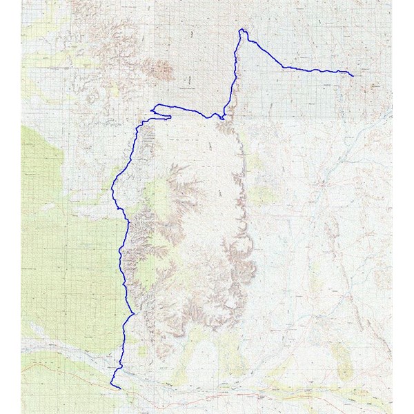
KR Plot
Cheers.
AnswerID:
553430
Reply By: Craig M1 - Thursday, May 07, 2015 at 22:17
Thursday, May 07, 2015 at 22:17
Thanks John that is the sort of encouragement my wife needs.
By the way have you done or know anything of the
Carnarvon Ranges north west of of
Wiluna,/south east of Kumarina road house .
Regards Craig
AnswerID:
553431
Follow Up By: Member - John Baas (WA) - Thursday, May 07, 2015 at 22:45
Thursday, May 07, 2015 at 22:45
Hi Craig.
Yes, have been to the CR - fabulous place and great POI's ... Unfortunately...
The Carnarvons have been closed by the TOs for some years altho they experimented last year with a 'once off' effort for guided access. They are not doing it in 2015 (do a search on this
forum - it's been extensively covered).
As Peter has said, west to east would be (much) easier if you haven't got electronic mapping and a plotfile. If there is
water in the Gascoyne, as referred to by Dunc. there is a way out to the west (or way in) via Mardathuna which totally bypasses it, but at the loss of some excellent scenery.
See
KR Mngmt Plan for much useful info.
Cheers.
FollowupID:
839274
Reply By: Craig M1 - Thursday, May 07, 2015 at 23:18
Thursday, May 07, 2015 at 23:18
Thanks John, yes I have been corresponding with the TO of the
Carnarvon Ranges. Just living in hope and wondering if they are as good as people say.
Thanks for the light reading.
Yes I have the Hema maps on an Ipad with GPS so hopefully won't get lost.
Thanks for the alternate route in from the west could be useful.
Regards Craig
AnswerID:
553433
Reply By: TrevorDavid - Saturday, May 09, 2015 at 12:55
Saturday, May 09, 2015 at 12:55
Graig M1
If you enter via Mooka Stn which I think is now ran by parks , stop & have a look at the Mookarite stone that they
mine a few Ks in . There's is a few natural springs along that way as
well. The new pub at Gassy
Junction pub
well worth a visit when your out that way
Regards
TrevorDavid
AnswerID:
553477
Follow Up By: get outmore - Saturday, May 09, 2015 at 13:58
Saturday, May 09, 2015 at 13:58
yes Parks bought out part of Mooka station to allow access to the western side of kennady ranges
that along with the many stations and parts of stations which were previosly locked out for travelling
really puts paid to the whinge p and w lock people out
FollowupID:
839339
Reply By: The Explorer - Saturday, May 09, 2015 at 18:09
Saturday, May 09, 2015 at 18:09
Hi
Geology of the Kennedy Ranges

Geology
Always interesting ....
well I think so.
Cheers
Greg
| I sent one final shout after him to stick to the track, to which he replied “All right,” That was the last ever seen of Gibson - E Giles 23 April 1874 Lifetime Member
My Profile My Blog Send Message
Moderator |
AnswerID:
553489
Follow Up By: Member - John Baas (WA) - Saturday, May 09, 2015 at 20:24
Saturday, May 09, 2015 at 20:24
Mookaite everywhere in the Mooka Ck bed.
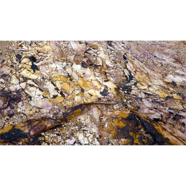
Mookaite Pic #1
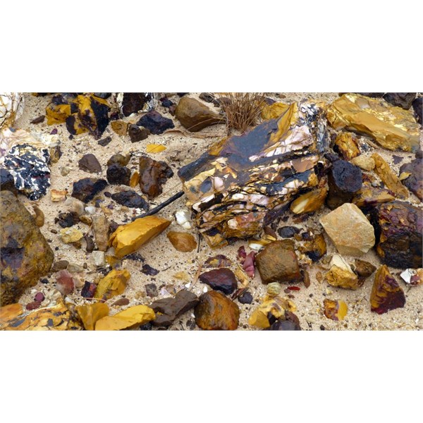
Mookaite Pic #2
Cheers.
FollowupID:
839369
Reply By: Craig M1 - Sunday, May 10, 2015 at 00:25
Sunday, May 10, 2015 at 00:25
Thanks guys, I enjoy a bit of gem stone hunting and brushing up on geology of the region. Sounds like its an interesting area to explore.
Regards Craig
AnswerID:
553517