Colson Track
Submitted: Saturday, Aug 15, 2015 at 14:27
ThreadID:
129998
Views:
3071
Replies:
5
FollowUps:
12
This Thread has been Archived
cookie1
Just wondering if anyone has any information on the Colson Track conditions & time taken to travel?
cheers
Reply By: Member - Ross N (NSW) - Saturday, Aug 15, 2015 at 20:34
Saturday, Aug 15, 2015 at 20:34
As far as I am aware travel on the Colson track requires permits for it's Northern section which are rarely , if ever, issued
Try CLC
Alice SpringsRoss Nielsen
AnswerID:
589288
Follow Up By: cookie1 - Sunday, Aug 16, 2015 at 08:03
Sunday, Aug 16, 2015 at 08:03
Thank you, have you actually travelled the Colson?
I am aware that it requires a permit and have indeed obtained one but thank you anyway
cheers
FollowupID:
857122
Follow Up By: Member - Ross N (NSW) - Sunday, Aug 16, 2015 at 08:53
Sunday, Aug 16, 2015 at 08:53
Only the Southern section about ten years ago.
Road condition was good compared to say the French Line.
Ross Nielsen
FollowupID:
857127
Reply By: Les - PK Ranger - Saturday, Aug 15, 2015 at 21:02
Saturday, Aug 15, 2015 at 21:02
Yes, pretty sure most stuff I've seen advise no permits are issued to drive Colson.
That said there's a lot of it not on aboriginal land, and plenty of people cross it or do small lower sections to get to / from other drives up there.
Maybe ask Joel Fleming when getting
Hay River permits (for your other trip).
He should know.
AnswerID:
589293
Follow Up By: cookie1 - Sunday, Aug 16, 2015 at 08:07
Sunday, Aug 16, 2015 at 08:07
Thanks Les,
I reckon your reading the same maps as I am ;-)
Jol has provided the permit for the
Hay River but only the CLC does the permits for the Colson and have indeed obtained one so we are doing a big loop of the Simpson
Just doing my homework before our trip the more I know the less suprises there are during the journey
cheers
FollowupID:
857123
Reply By: PhilD - Saturday, Aug 15, 2015 at 22:29
Saturday, Aug 15, 2015 at 22:29
The Colson was a fairly easy drive as it runs between the dunes generally, but was very overgrown some years ago in the northern to middle section, so some bush bashing was needed.
AnswerID:
589297
Follow Up By: cookie1 - Sunday, Aug 16, 2015 at 07:58
Sunday, Aug 16, 2015 at 07:58
Thanks Phil D - the information I was looking for
cheers
FollowupID:
857121
Follow Up By: cookie1 - Sunday, Aug 16, 2015 at 08:08
Sunday, Aug 16, 2015 at 08:08
Oh for an edit button
How many days did it take you?
cheers
FollowupID:
857124
Follow Up By: PhilD - Sunday, Aug 16, 2015 at 09:17
Sunday, Aug 16, 2015 at 09:17
About 2 days from
Ross River to the French Line. We were on the middle section overnight and camped on the track as there were no clear areas, but it could be different depending on the season.
FollowupID:
857130
Follow Up By: cookie1 - Sunday, Aug 16, 2015 at 10:14
Sunday, Aug 16, 2015 at 10:14
I have read the Northern entrance is fairly
well camofladged, is it? or did you go from the South?
cheers
FollowupID:
857135
Follow Up By: PhilD - Sunday, Aug 16, 2015 at 18:33
Sunday, Aug 16, 2015 at 18:33
Came in from Numery Station (the north). The
old sign was on the ground. We just used the GPS as the road out to Numery runs past the station buildings and then hits the top of the Colson. There was nothing to tell you where it was.
FollowupID:
857159
Follow Up By: cookie1 - Sunday, Aug 16, 2015 at 19:01
Sunday, Aug 16, 2015 at 19:01
Thanks Phil, you have been a great help
we are now intending to go from the South so that we can track out at Numery without missing the turn off, as far as I can ascertain it is a bit overgrown now so will have to trust the Hema, has not let us down yet and we have done some pretty overgrown tracks in the past - Cape & Canning.
cheers
FollowupID:
857161
Follow Up By: PhilD - Sunday, Aug 16, 2015 at 23:13
Sunday, Aug 16, 2015 at 23:13
Have a great trip! I would be interested to hear what the track is like when you return.
FollowupID:
857187
Reply By: Robin Miller - Monday, Aug 17, 2015 at 08:12
Monday, Aug 17, 2015 at 08:12
Recently the track was in such good condition that it was driven in 2wd , its dead straight and flat for most of the way south from
camp 5 .
There are however very few
places to
camp , we drove that whole bit from 4pm to 8pm at night before a place to put up a tent was found.
AnswerID:
589345
Follow Up By: cookie1 - Monday, Aug 17, 2015 at 08:47
Monday, Aug 17, 2015 at 08:47
Thanks Robin
wow sounds like a pretty straight forward drive then, we are aiming to not be on the Lands for very long
camping at Colson Oil
Well then at Hale River at the top so it does sound quite achievable.
2wd was that due to a problem as we normally do 4wd whenever we hit remote outback tracks to avoid damaging the tracks
thanks again for your reply
cheers
FollowupID:
857198
Follow Up By: Robin Miller - Monday, Aug 17, 2015 at 10:26
Monday, Aug 17, 2015 at 10:26
Hi Cookie
No 2wd was more of statement on the quality of the track , go off it and its 4wd for sure , but as the attached picture shows its mostly hard and straight.
The photo is in area near the Oil
well.
On many tracks out there you only average 12kmh but on this one the entire 200km from French line to
Camp 5 can safely be done at 50 , just a couple of short wash away sections in the middle to watch out for.
The booklet , Nth
Simpson Desert, describes this section
well, but really its a straight line no issues.
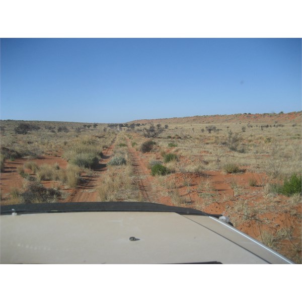
Colson Oil Well area
FollowupID:
857207
Reply By: Echucan Bob - Thursday, Aug 20, 2015 at 21:49
Thursday, Aug 20, 2015 at 21:49
Cookie,
we've passed that way a couple of times. As others have said its a doddle. The track runs along the swale, occassionally crossing a low dune into the next swale. Lots of camels that stupidly run along in front of you for kilometers instead of veering off over a dune to the right or left.
There are unlimited
places to
camp provided you don't mind unfurling the swag on flat red sand between clumps of spinifex. From the tops of the dunes you can see hundreds of dunes peeling off into the distance.
There is one place on the northern end where the track passes through a panel in a fence. The first time we missed this, and with early GPS mapping gear we travelled for some distance before we realised our mistake.
I have been able to spot the Colson from the air (with the assistance of GPS). It makes you realise how remote this track really is.
From Alice to the French line is about a day of driving.
I lost an outbacker multi tap whip from the trailer in 2001. Keep an eye out for it if you can please.
Bob
Bob
AnswerID:
589478