Where is the east end of the Gunbarrel Hwy?
Submitted: Wednesday, Aug 26, 2015 at 07:55
ThreadID:
130098
Views:
3543
Replies:
4
FollowUps:
10
This Thread has been Archived
Member - Boobook
Traveling on much of the Gunbarrel Hwy in 4 weeks with all permits in hand. :-)
After heading through
Maralinga, the ABH, Connie Sue and
Warburton, the plan is to go up to the Gunbarrel ad head east.
I am just trying to determine where the Gunbarrel actually was, east of Giles. Some maps ( inc EO) show it as heading to Uluru, which can't be right, others show it as stopping at the
SA border near
Surveyor generals corner ( Westprint).
However Len talks about starting just north of the NT
SA border and heading west.
Even the Len Beadell website shows nothing east of Mulga
Park.
I make it that the
Mulga Park Rd , and then the Giles Mulga
Park Rds were originally called the Gunbarrel Hwy.
Does anyone know for sure where it went on the east side of Giles.
Also I am having real trouble calling to book the SG corner, they never call back.
I'm going by the numbers on the Hema Map 08 8956 7566 and 08 8956 7998
I am pretty sure I have to book ahead and no weekends, is that right?
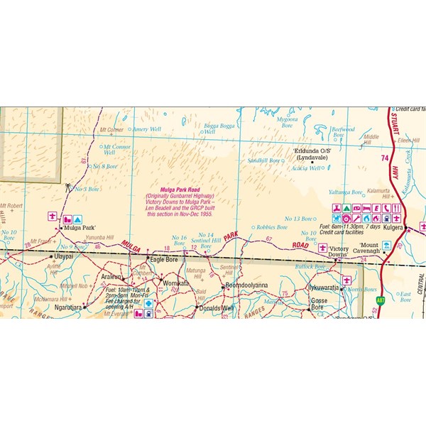
Reply By: The Explorer - Wednesday, Aug 26, 2015 at 09:28
Wednesday, Aug 26, 2015 at 09:28
Hello
The 2008 250K Natmap gives the impression that the Gunbarrel starts around Victory Downs Station. Appears to be called Mulga
Park Road on other maps. Mulga
Park Road joins the Stuart Highway about 19 kms south of
Kulgera.
I dont know, but suspect the current Mulga
Park Road and sections marked as the Gunbarrel (in the east at least) have a number of slight deviations from the "real"
Gunbarrel Highway which have been created over time so if you are a purist you may need to do some more research to ensure you dont take any shortcuts. I am lead to believe Alan (AKA Equinox) knows the way.
Cheers
Greg
| I sent one final shout after him to stick to the track, to which he replied “All right,” That was the last ever seen of Gibson - E Giles 23 April 1874 Lifetime Member
My Profile My Blog Send Message
Moderator |
AnswerID:
589658
Follow Up By: equinox - Wednesday, Aug 26, 2015 at 19:08
Wednesday, Aug 26, 2015 at 19:08
Hi Greg / Boobook
As you've stated the highway ends (or starts really) at Victory Downs.
There's a few
places where the road has been upgraded and is a bit off here and there.
If your going from
Warburton take what is called the
Warburton North Road up to JJ. This was the original highway.
After Giles keep going to the Giles Mulga
Park Road turnoff and turn south.
Turnoff
As a side note this turnoff is actually the original terminus of the
Sandy Blight Junction Road, not the other one 45kms or so to the north east.
Being really pedantic the original Gunbarrel actually is a
fork to the right 100 metres or so before the
sign.
Then just keep going to Victory Downs. The last 400 metres or so before Victory Downs the main road forks. Most people go this way as that is the main road these days however if you really want to say you've done the highway you will have to go to the
homestead itself (that's the only part of the highway I haven't done yet)
Cheers
Alan
FollowupID:
857592
Follow Up By: Echucan Bob - Thursday, Aug 27, 2015 at 23:21
Thursday, Aug 27, 2015 at 23:21
Alan, you say "Then just keep going to Victory Downs." Is that down through Wingellina and then along the top of the APY Lands in SA, then up to Mulga
Park and across to VD? We've done this end and the Mt Davies Road several times.
I haven't done the JJ bit (yet). In 1998 did the Heather Hwy bit that joined the GBH (managed to get lost and got a very unfriendly welcome at Tjirrkarli!) The old Pajero was never quite the same after the GBH corrugations.
Bob
FollowupID:
857661
Follow Up By: equinox - Thursday, Aug 27, 2015 at 23:54
Thursday, Aug 27, 2015 at 23:54
Bob,
Yes, east of Charnock Flats, south of Wingella, past Gosse pile and past Amata.
The JJ bit north of
Warburton after the main drag is an old rarely used track, surprised more people don't drive it to be honest.
Alan
FollowupID:
857662
Reply By: Idler Chris - Wednesday, Aug 26, 2015 at 11:55
Wednesday, Aug 26, 2015 at 11:55
Westprint's Alice_uluru_ed5 map shows the Old
Gunbarrel Highway starting 26 kilometres south east of of the
Warakurna Roadhouse at 25 09' 36" S 128 31' 25" E heading south. The original
Gunbarrel Highway extends through Pitjantjatiara Aboriginal Lands in SA to Victory Downs Station near the Stuart Highway about 40 kilometres south west of
Kulgera. Permits are required to travel this route.
| What other people think of me is none of my business.
Do unto others what you would have them do unto you.
The word "hate" is not in my vocabulary. Lifetime Member
My Profile My Blog My Position Send Message |
AnswerID:
589663
Follow Up By: The Explorer - Wednesday, Aug 26, 2015 at 12:49
Wednesday, Aug 26, 2015 at 12:49
Hi
Western end of the Gunbarrel Hwy is (from what I can figure) at
Carnegie Station ~545km east of
Warakurna Roadhouse. The term "Old Gunbarrel", it is just an "abandoned" section but still the Gunbarrel none the less.
Cheers
Greg
| I sent one final shout after him to stick to the track, to which he replied “All right,” That was the last ever seen of Gibson - E Giles 23 April 1874 Lifetime Member
My Profile My Blog Send Message
Moderator |
FollowupID:
857570
Reply By: Member - Scott M (NSW) - Wednesday, Aug 26, 2015 at 14:30
Wednesday, Aug 26, 2015 at 14:30
Interestingly, HEMA shows this
gbh
AnswerID:
589671
Reply By: Member - Boobook - Wednesday, Aug 26, 2015 at 15:25
Wednesday, Aug 26, 2015 at 15:25
Thanks everybody they are all consistent with what I thought and what is in Len's book.
I think EO and Westprint may need to update their info.
Also any advice on SG corner?
AnswerID:
589674
Follow Up By: Idler Chris - Wednesday, Aug 26, 2015 at 16:45
Wednesday, Aug 26, 2015 at 16:45
You asked the question about the east end of the Gunbarrel. My response was from an outdated Westprint map as that had the answer to the question you asked. I never said it was the latest map.
| What other people think of me is none of my business.
Do unto others what you would have them do unto you.
The word "hate" is not in my vocabulary. Lifetime Member
My Profile My Blog My Position Send Message |
FollowupID:
857582
Follow Up By: The Explorer - Wednesday, Aug 26, 2015 at 18:53
Wednesday, Aug 26, 2015 at 18:53
Relax Max (Chris:) - we dont know the currency of the WP map Boobook was looking at (or yours). I have (subsequent to previous replies) tracked down a WP map I have in my possession (South East - dated 2003 by the looks) - actually labels track to Victory Downs the "Old Gunbarrel" as also indicated on 2008 250K topo.
The EO 200K Topo map labels the Gunbarrel at the east end as Mulga
Park Road (fair enough - assume that's its current official name?) but does also have an over plotted trek stating "Uluru via Old Gunbarrell (sic)" - a slightly ambiguous hint to its historic identity at this location.
So...update probably not required in both cases but maybe some additional annotation on some maps to clarify history/start- finish/location.
Cheers
Greg
| I sent one final shout after him to stick to the track, to which he replied “All right,” That was the last ever seen of Gibson - E Giles 23 April 1874 Lifetime Member
My Profile My Blog Send Message
Moderator |
FollowupID:
857590
Follow Up By: The Explorer - Wednesday, Aug 26, 2015 at 19:44
Wednesday, Aug 26, 2015 at 19:44
No worries
Now that we have that sorted - the most important thing, have a good safe trip!
Cheers
Greg
| I sent one final shout after him to stick to the track, to which he replied “All right,” That was the last ever seen of Gibson - E Giles 23 April 1874 Lifetime Member
My Profile My Blog Send Message
Moderator |
FollowupID:
857596
Follow Up By: equinox - Wednesday, Aug 26, 2015 at 19:46
Wednesday, Aug 26, 2015 at 19:46
Boobook, EO is aware of the situation and will not change it - see my thread
65650 from 2009.
I still disagree with this, however it is their site so they can say what they want to be honest.
FollowupID:
857597
Follow Up By: Member - Scott M (NSW) - Thursday, Aug 27, 2015 at 00:14
Thursday, Aug 27, 2015 at 00:14
equinox, agree. What they have mapped is the GCR, not the GBH.
FollowupID:
857612