Detailed map of Karlamilyi National Park
Submitted: Wednesday, Feb 03, 2016 at 13:35
ThreadID:
131540
Views:
9577
Replies:
6
FollowUps:
7
This Thread has been Archived
Member - DingoBlue(WA)
Hi All,
Am trying to find a detailed map of Karlamilyi National
Park, None of the paper maps (such as Hema GDT North West) Have much info. Parks and Wildlife and other sites have rudimentary maps only.
MickO has detailed many areas within the
park in his
blogs but I'm unable to find a map showing them.
Can anyone advise me where I might be able to download or purchase something that could be useful?
Reply By: Bob Y. - Qld - Wednesday, Feb 03, 2016 at 14:30
Wednesday, Feb 03, 2016 at 14:30
This one any good to you, DB? From the Hema collection on my iPad.
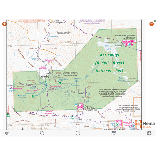
Rudall River WA
Couldn't fit it all in one grab. Could do 2 if you think it's okay?
Bob
AnswerID:
595869
Follow Up By: Member - DingoBlue(WA) - Wednesday, Feb 03, 2016 at 18:40
Wednesday, Feb 03, 2016 at 18:40
Thanks Bob,
have the same on my HN7 but was hoping for a paper map. Just like to have a backup besides, the paper can have multiple uses!
FollowupID:
864620
Follow Up By: Bob Y. - Qld - Thursday, Feb 04, 2016 at 11:35
Thursday, Feb 04, 2016 at 11:35
Ha ha, that's true, DB.
In some instances, one could add "tracks" to the map that might be difficult to negotiate. :-)
Bob
FollowupID:
864654
Follow Up By: Member - DingoBlue(WA) - Thursday, Feb 04, 2016 at 11:42
Thursday, Feb 04, 2016 at 11:42
Just follow the skid marks....
FollowupID:
864656
Reply By: Life Member - Fred B (ex-NT) - Wednesday, Feb 03, 2016 at 17:02
Wednesday, Feb 03, 2016 at 17:02
Westprint maps have a map showing most points of interest on it (not a topo map). Other than that, I used Natmap digital maps and had to print out multiple pages to get what I wanted. I used oziexplorer, put all the
places of interest as waypoints and then printed it. I also did the the same with google earth. Mick O might have some other info for you.
regards
AnswerID:
595874
Follow Up By: Member - DingoBlue(WA) - Wednesday, Feb 03, 2016 at 18:41
Wednesday, Feb 03, 2016 at 18:41
Thanks Fred,
It looks like I may have to do similar
FollowupID:
864621
Follow Up By: Sigmund - Thursday, Feb 04, 2016 at 11:10
Thursday, Feb 04, 2016 at 11:10
Check out the app called Avenza PDF Maps. From within it you can d/l most Natmap topos free. (The popular ones are charged for but there's a rolling levy on which ones, so you might be lucky). Course these are 250k and a decade or more old.
FollowupID:
864653
Reply By: Member - Michael P (QLD) - Wednesday, Feb 03, 2016 at 21:33
Wednesday, Feb 03, 2016 at 21:33
D.B. Hi,
Have a book "Road & Tracks" Western Australia. Published by Quality Publishing Australia www.qualitypublishing.com.au 7 Bishop st Jolimont WA 6014.
The map of KNP are more than equal to the Hema digital.
Don't know if they produce in sheet form but would be surprised if they didn't.
Cheers Mike.
AnswerID:
595881
Follow Up By: Member - DingoBlue(WA) - Wednesday, Feb 03, 2016 at 21:38
Wednesday, Feb 03, 2016 at 21:38
Thanks Michael,
Will be out Jolimont way in the next few days so will check it out.
FollowupID:
864634
Reply By: equinox - Wednesday, Feb 03, 2016 at 21:48
Wednesday, Feb 03, 2016 at 21:48
Hi DingoBlue,
Your could try the Natmap series. Start with Rudall and get the surrounding maps if you want.
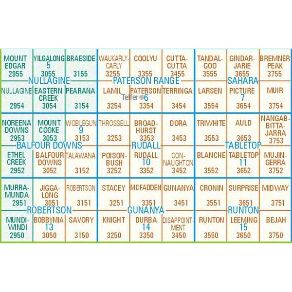
Adjoining maps
Some maps
shop will still have them or you could just go in to Landgate in Midland.
Order Online and details
Cheers
Alan
AnswerID:
595884
Follow Up By: Member - DingoBlue(WA) - Wednesday, Feb 03, 2016 at 21:51
Wednesday, Feb 03, 2016 at 21:51
ThanksAlan,
I couldn't enlarge the legend enough to read the maps. Will call into Landgate and have a squizz.
FollowupID:
864635
Reply By: Mick O - Wednesday, Feb 03, 2016 at 22:27
Wednesday, Feb 03, 2016 at 22:27
DB, there is so much in Rudall and the surrounding areas that are not marked on maps. I tend to use a combo of Hema, Westprint and Natmaps 250K sheets for the area. I believe that
EOTopo maps may display the EO "places" within RudalI that I have created over the years but you will not find established tracks to most, a point I often make within the 'Place' descriptions on the site.
There is a fairly comprehensive index of features or "Places" that I have compiled or contributed to in my
Rudall River Blog.
If there are some
places in particular, I may be able to assist you with a track file in Google earth or Garmin formats but many of these
places were visited using quads or on foot.
Let me know through a Member Message,
Regards
Mick
AnswerID:
595887
Reply By: Dean K3 - Thursday, Feb 04, 2016 at 19:04
Thursday, Feb 04, 2016 at 19:04
Another "possibility" is DPaW map section. I have several of thier maps for southwest and around hills area where I live, reasonably priced as
well. last time i paid $15 from memory so maybe $20 these days
I know I have seen their employees (firies and other parks people) with a spiral bound book of all their maps but they aren't for sale to public.compared to regular maps DLI ordnance they are uptodate compared to others around.
AnswerID:
595916