Mount Jackson Road from west
Submitted: Wednesday, Feb 17, 2016 at 20:40
ThreadID:
131630
Views:
5137
Replies:
4
FollowUps:
9
This Thread has been Archived
equinox
Hi there,
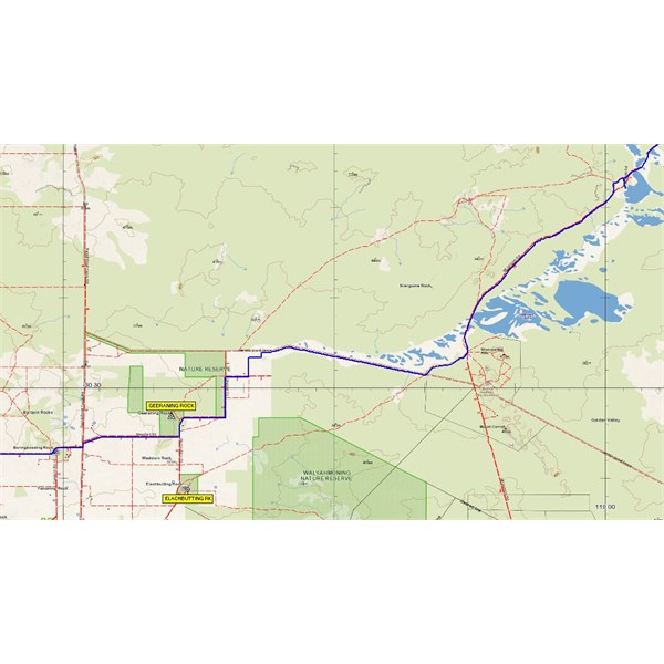
Is it possible to access
Mount Jackson Road from
Bonnie Rock area? I'm thinking via
Geeraning Rock or
Vermin proof Fence (I know Dept of Ag usually aren't keen on people driving along their active fences). There's also a track heading east from
Elachbutting Rock on the map.
Might save half an hour or so than getting on
Mount Jackson Road just north of Lake Baladjie.
Thanks and cheers
Alan
Reply By: Rod W6 - Wednesday, Feb 17, 2016 at 22:39
Wednesday, Feb 17, 2016 at 22:39
The Barrier fence is classed as a workplace. It is supposedly under remote camera surveillance and unauthorised and heavy fines are imposed on unauthorised vehicles. The fines were $2,000 but I think that has been increased significantly.
You can get to Mt Jackson Road via
Elachbutting Rock to Walyahmoning Rock and onto the southern line/road through to Mt Jackson road. There is some pretty specie breakaways at the back of Walyahoning Rock
AnswerID:
596344
Follow Up By: equinox - Wednesday, Feb 17, 2016 at 22:50
Wednesday, Feb 17, 2016 at 22:50
Thanks Rod, just the info I was after.
What's the condition of the track past Walyahmoning Rock to
Mount Jackson Track? Is it generally overgrown or fairly clear?
Cheers
FollowupID:
865226
Follow Up By: Rod W6 - Thursday, Feb 18, 2016 at 08:51
Thursday, Feb 18, 2016 at 08:51
Its a super highway. So equinox when might you be going to that neck of the woods and where to once you hit the jackson road. You don't have to say if you don't want to.
FollowupID:
865233
Follow Up By: equinox - Friday, Feb 19, 2016 at 21:06
Friday, Feb 19, 2016 at 21:06
I think I found the turn-off however was much more south than I anticipated.
I went around
the rock a couple of times first searching for where the track was on the map.
Ended up going on the old track north of the lake as your track looked to much like it was going through private property at the start.
Thanks again.
FollowupID:
865289
Reply By: Stephen F2 - Thursday, Feb 18, 2016 at 00:05
Thursday, Feb 18, 2016 at 00:05
Hiya sorry can not help but can you please fill.me in on where MT JACKSON rd is sounds interesting cheers
AnswerID:
596345
Follow Up By: equinox - Thursday, Feb 18, 2016 at 00:19
Thursday, Feb 18, 2016 at 00:19
Hi Stephen - it's a road from
Bullfinch. Its passes in between Lake Baladjie and Lake Deborah West, then Hamersley Lakes before coming out onto
Bullfinch Evanston Road east of
Mount Jackson.
FollowupID:
865227
Reply By: Gone Bush (WA) - Thursday, Feb 18, 2016 at 12:11
Thursday, Feb 18, 2016 at 12:11
Alan, I've got to the Mt Jackson Rd from the west via two separate tracks in the past.
The most recent was via the that track others mentioned. I don't know how stringently access is policed, locals use it to get to a very popular
granite rock outcrop on the opposite side to Grosser Rd (Eagle Rock jogs my memory but I'm not certain, I might just be channelling Daddy Cool).
The other way was quite a few years ago and required permission from a landowner (which was readily given). That was to proceed along Hunter Rd to the
intersection with Boodarockin Nth Rd and then through a
gate (that's where permission is required) and proceed along a track in a NE direction. Access inside the landowner's property was only for about 200 metres then it was out through another
gate. The beauty of this track was seeing Barcooting
Hill. It's another of those rocky outcrops that was used as a watering hole for the early bullock teams heading to the goldfields. I think you would like the history associated with this type of place.
When you get to Mt Jackson Rd I really recommend stopping at
Trough Well. Fantastic brickwork and many nice flat campsites.
Before you leave the
Beacon area, there are many beautiful
granite rock outcrops that I am sure you know about already. Some ideas here:
Granite Loop Trail
AnswerID:
596354
Follow Up By: equinox - Thursday, Feb 18, 2016 at 15:36
Thursday, Feb 18, 2016 at 15:36
Hi GB,
Thanks will try the northern route first I think.
I did pass that turn-off to Barcooting
Hill a few years back and it looked like a viable option.
I might see if I can visit
Trough Well on the way back.
Cheers
Alan
FollowupID:
865258
Follow Up By: equinox - Friday, Feb 19, 2016 at 20:59
Friday, Feb 19, 2016 at 20:59
GB, went to
Trough Well.
The main
tank was almost empty but the rockhole was quite full (of algea). Great setup with all the brickwork.
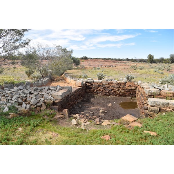
Trough Well
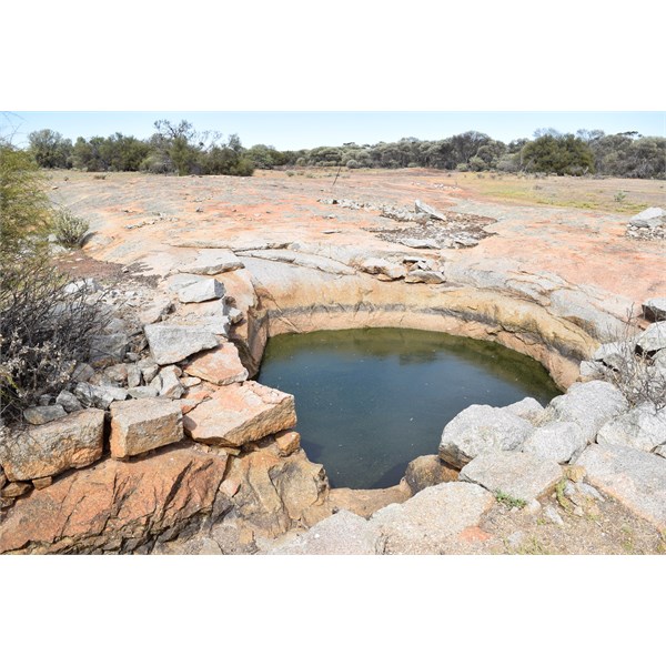
Trough Well
FollowupID:
865287
Reply By: Member - John Baas (WA) - Thursday, Feb 18, 2016 at 23:33
Thursday, Feb 18, 2016 at 23:33
Hi Alan.
The Club has used the VPF option a number of times without any issues. You also need to go thru a short section of a wheat paddock. Gates are closed but not locked - apparently the Club got a permission years ago. Phil B might have details.
See pic.
Acces to Mt Jackson Rd from the west.
Cheers.
AnswerID:
596376
Follow Up By: equinox - Friday, Feb 19, 2016 at 21:02
Friday, Feb 19, 2016 at 21:02
Hi JB,
Thanks however only read this when back home.
I did try and contact Phil B but he was MIA.
Looks like the quickest option.
Cheers
Alan
FollowupID:
865288
Follow Up By: Member - John Baas (WA) - Friday, Feb 19, 2016 at 22:51
Friday, Feb 19, 2016 at 22:51
Yes, I think it's possibly a 'rat-run' for wheatbelt farmers looking to get up the Evanston road by passing the Sthn Cross/
Bullfinch dogleg...?
However, there is a short scratchy section once you leave the RPF heading eastish; not that it'd worry you....
Cheers.
FollowupID:
865292